
Webb County, Texas facts for kids
Quick facts for kids
Webb County
|
||
|---|---|---|
| County of Webb | ||

Webb County Courthouse in Laredo
|
||
|
||

Location within the U.S. state of Texas
|
||
| Country | ||
| State | ||
| Established | January 28, 1848 | |
| Organized | March 16, 1848 | |
| Named for | James Webb | |
| County seat | Laredo | |
| Largest city | Laredo | |
| Government | ||
| • Type | Commissioners Court | |
| Area | ||
| • Total | 3,375 sq mi (8,740 km2) | |
| • Land | 3,361 sq mi (8,700 km2) | |
| • Water | 14 sq mi (40 km2) 0.4% | |
| Population
(2020)
|
||
| • Total | 267,114 | |
| • Density | 79.145/sq mi (30.558/km2) | |
| Time zone | UTC−6 (Central) | |
| • Summer (DST) | UTC−5 (CDT) | |
| Area code | 956 | |
| FIPS code | 48479 | |
| GNIS feature ID | 1384025 | |
| Website | www.webbcountytx.gov | |


Webb County is a large county in the state of Texas. In 2020, about 267,114 people lived there. Its main city, or county seat, is Laredo.
The county is named after James Webb. He was an important person in the early days of the Republic of Texas. He served as a secretary and later as a judge. Webb County is the biggest county in South Texas by size. It is also the sixth-largest county in the whole state.
Webb County is special because it is the only county in the United States that borders three different foreign states or provinces. It shares borders with Coahuila, Nuevo Leon, and Tamaulipas in Mexico. Most people in Webb County are of Hispanic background. About 95% of the people identify as Hispanic. This makes it one of the counties with the highest percentage of Hispanic people in the United States.
Contents
History of Webb County
Webb County was created in 1848. A part of it was once a separate county called Encinal County. This happened in 1856. However, Encinal County was never fully set up. It was later dissolved in 1899, and its land became part of Webb County again.
A big part of Webb County's history involves ranching. This is the practice of raising livestock like cattle. Ranching has been important since the 1800s and continues today. The Webb County Heritage Foundation works to keep the county's history alive. This group collects old documents and items. They want to make sure that the stories and past of the area are remembered by future generations.
Geography and Travel
Webb County covers a large area. It has a total area of about 3,376 square miles. Most of this is land, with a small amount of water.
Major Roads in Webb County
The Webb County - City of Laredo Regional Mobility Authority helps manage the roads and transportation in the area. Many important highways run through Webb County.
 I-35
I-35 US 59
US 59 US 83
US 83 Loop 20
 SH 359
Neighboring Areas
Webb County shares its borders with several other counties in Texas. It also borders parts of Mexico.
- Dimmit County (north)
- La Salle County (north)
- Duval County (east)
- Jim Hogg County (southeast)
- Zapata County (south)
- Maverick County (northwest)
- McMullen County, Texas (northeast)
- Guerrero, Coahuila, Mexico (west)
- Hidalgo, Coahuila, Mexico (west)
- Anáhuac, Nuevo León, Mexico (west)
- Nuevo Laredo, Tamaulipas, Mexico (south)
- Guerrero, Tamaulipas, Mexico (southwest)
Population Facts
| Historical population | |||
|---|---|---|---|
| Census | Pop. | %± | |
| 1860 | 1,397 | — | |
| 1870 | 2,615 | 87.2% | |
| 1880 | 5,273 | 101.6% | |
| 1890 | 14,842 | 181.5% | |
| 1900 | 21,851 | 47.2% | |
| 1910 | 22,503 | 3.0% | |
| 1920 | 29,152 | 29.5% | |
| 1930 | 42,128 | 44.5% | |
| 1940 | 45,916 | 9.0% | |
| 1950 | 56,141 | 22.3% | |
| 1960 | 64,791 | 15.4% | |
| 1970 | 72,859 | 12.5% | |
| 1980 | 99,258 | 36.2% | |
| 1990 | 133,239 | 34.2% | |
| 2000 | 193,117 | 44.9% | |
| 2010 | 250,304 | 29.6% | |
| 2020 | 267,114 | 6.7% | |
| U.S. Decennial Census 1850–2010 2010 2020 |
|||
In 2020, the population of Webb County was 267,114 people. Most of the people living in Webb County are of Hispanic or Latino background. In 2020, about 95.2% of the population was Hispanic or Latino.
In 2000, there were 193,117 people living in the county. About 50,740 households were counted. Many households (53.2%) had children under 18 living with them. The average household had about 3.75 people.
The median age in the county was 26 years old. This means half the people were younger than 26 and half were older. About 36.2% of the population was under 18 years old. The average income for a household in 2000 was about $28,100. About 31.2% of the people lived below the poverty line. This included many children and older adults.
Education
Three main school districts serve the students of Webb County:
- Laredo Independent School District
- United Independent School District
- Webb Consolidated Independent School District
Before 1994, the Webb Consolidated Independent School District (CISD) served only the towns of Bruni and Oilton. Another district, Mirando City Independent School District, served Mirando City until 2005. After 1994, Mirando City High School closed. High school students from Mirando City then went to Webb CISD schools. In 2005, the Texas Education Agency closed Mirando City ISD. All its students then joined Webb CISD.
Laredo College is a local college that all residents of Webb County can attend.
Communities
Webb County has several cities and many smaller communities.
Cities
Census-Designated Places (CDPs)
CDPs are special areas that are like towns but not officially incorporated as cities.
- Aguilares
- Bonanza Hills
- Botines
- Bruni
- Colorado Acres
- Four Points
- Hillside Acres
- La Coma
- La Moca Ranch
- La Presa
- Laredo Ranchettes
- Laredo Ranchettes West
- Las Haciendas
- Las Pilas
- Los Altos
- Los Arcos
- Los Centenarios
- Los Corralitos
- Los Fresnos
- Los Huisaches
- Los Minerales
- Los Nopalitos
- Los Veteranos I
- Los Veteranos II
- Mirando City
- Oilton
- Pueblo East
- Pueblo Nuevo
- Ranchitos East
- Ranchitos Las Lomas
- Ranchos Penitas West
- San Carlos I
- San Carlos II
- Sunset Acres
- Tanquecitos South Acres
- Tanquecitos South Acres II
- Valle Verde
Other Small Communities
These are other communities that are not officially cities or CDPs.
- Cactus
- Callaghan
- D-5 Acres Colonia
- East Gate Acres Colonia
- Las Tiendas
- Minera
- Old Milwaukee East
- Old Milwaukee West
- Palafox
- Ranchitos los Mesquites Colonia
- Ranchitos los Veteranos Colonia
- San Pablo
- San Ramon
- Village East Colonia
- Webb
Ghost Towns
These are towns that were once active but are now abandoned.
Images for kids
-
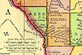
Map of Webb and Encinal Counties in 1895
-
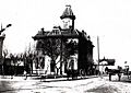
Webb County Courthouse in 1905
-
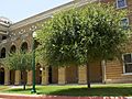
Webb County Courthouse today
-
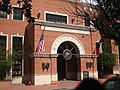
Entrance to the William N. "Billy" Hall Administrative Building annex of the Webb County Courthouse in Laredo
-
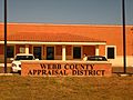
The Webb County Appraisal District Office in Laredo appraises taxable real property for municipal and county governments, Laredo Community College, and both public school districts.
-
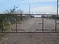
Entrance to the J. O. Walker, Jr., Piedra Parada Ranch in eastern Webb County
-
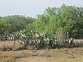
Opuntia cacti abound throughout much of Webb County.
-
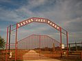
The Cactus Jack Ranch in northwestern Webb County is named for U.S. President Franklin D. Roosevelt's first vice president, John Nance Garner of Uvalde. Imported saguaro cacti are planted at the gate.
-
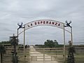
Entrance gate to La Esperanza (Hope) Ranch in northwestern Webb County near the Dimmit County boundary
-
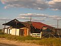
This abandoned building along U.S. Route 83 in northwestern Webb County reflects the isolation of the South Texas ranch country.
-
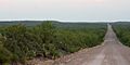
Road through Tamaulipan thornscrub, Webb County, Texas, USA (10 June 2016)
-
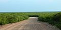
Road through Tamaulipan thornscrub, Webb County, Texas, USA (10 June 2016)

.jpg)


.jpg)
.jpg)
See also
 In Spanish: Condado de Webb para niños
