Kinney County, Texas facts for kids
Quick facts for kids
Kinney County
|
|
|---|---|

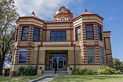
The Kinney County Courthouse was built in 1910 and is an example of Beaux Arts Classicism architecture. It was added to the National Register of Historic Places in 2004.
|
|

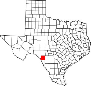
Location within the U.S. state of Texas
|
|
 Texas's location within the U.S. |
|
| Country | |
| State | |
| Founded | 1874 |
| Named for | Henry Lawrence Kinney |
| Seat | Brackettville |
| Largest city | Brackettville |
| Area | |
| • Total | 1,365 sq mi (3,540 km2) |
| • Land | 1,360 sq mi (3,500 km2) |
| • Water | 5.1 sq mi (13 km2) 0.4%% |
| Population
(2020)
|
|
| • Total | 3,129 |
| • Density | 2.6/sq mi (1.0/km2) |
| Time zone | UTC−6 (Central) |
| • Summer (DST) | UTC−5 (CDT) |
| Congressional district | 23rd |
Kinney County is a county located in the U.S. state of Texas. In 2020, about 3,129 people lived there. Its main town, or county seat, is Brackettville. The county was created in 1850 and officially set up in 1874. It is named after Henry Lawrence Kinney, an early settler in the area.
Since the 2010s, Kinney County has faced challenges with people crossing the border from Mexico without permission. The county has said it doesn't have enough resources to handle the large number of people. In 2021, it declared a state of emergency to get more help.
Contents
History
Early People and Tribes
The first people lived in this area between 6,000 and 10,000 years ago. Later, tribes like the Lipan Apache, Mescalero Apache, Coahuiltecan, Jumanos, Tamaulipans, Tonkawa, and Comanches made their homes here. They often lived in rock shelters near rivers and creeks. They left behind interesting things like tools, seeds, burial sites, and rock carvings.
After the Civil War, some Native American groups, including the Kickapoo, Seminole, and Lipan Apache, sometimes raided the area. These raids mostly stopped by the late 1870s and early 1880s.
First European Explorers
In 1665, Fernando de Azcué from Saltillo, Mexico, was the first European to cross the Rio Grande in this area. Other explorers, like Franciscan Brother Manuel de la Cruz in 1674 and Fernando del Bosque in 1675, also explored the county.
In 1688, Alonso De León found a French explorer named Jean Henri near what is now Brackettville. Later, in the late 1700s, some Franciscans tried to start a settlement near Las Moras Creek. In 1834, two English land developers tried to create an English-speaking colony called Dolores, but it didn't last.
How the County Was Formed
The state of Texas officially created Kinney County from Bexar County in 1850. It was named after Henry Lawrence Kinney. In 1852, the United States Army built Fort Clark on Las Moras Creek. It was named after John B. Clark.
The town of Brackettville was also founded in 1852. It was first called Brackett, named after Oscar B. Brackett, who set up a stagecoach stop and the town's first store. Brackettville became a stop on a stagecoach route from San Antonio to El Paso. However, the town grew slowly because of ongoing Native American attacks. It got its first post office in 1875.
During the Civil War, Fort Clark was handed over to the Texas Commission in 1861 and was held by Confederate troops. After the war, in 1866, it became a federal fort again.
Black Seminole Scouts
In 1872, a group of Black Seminoles who lived near the border became scouts for Fort Clark. More joined them, and by the mid-1870s, there were about 400 to 500 of them. For the next 25 years, they lived on a special area near Las Moras Creek. In 1914, they moved from the fort's land, but some of their family members still live in the county today. The Seminole Indian Scouts cemetery was started at Fort Clark in 1872.
County Growth and Development
Kinney County officially organized its government in 1874. In 1876, Brackettville became the official county seat. In the 1870s, the county had many cattle. By 1880, sheep farming became very important, and Kinney County was known for its wool.
The building of the Galveston, Harrisburg and San Antonio Railway (now part of the Union Pacific Railroad) through Spofford in 1883 helped the wool and mohair industries. It also brought many new settlers to the area. In 1925, another train line was built to connect with the Mexican National Railroad.
During the Great Depression, a large camp called the Civilian Conservation Corps helped provide jobs. When World War II started, wool and mohair were needed for defense. Fort Clark closed in 1946.
In the late 1950s, James T. “Happy” Shahan built Alamo Village on his ranch near Brackettville. This was used to film the 1960 movie The Alamo starring John Wayne. Alamo Village became a tourist spot and was used for many other movies. In 1969, Happy Shahan helped singer Johnny Rodriguez start his career at Alamo Village.
Kickapoo Cavern State Park, a large park of about 6,400 acres (26 square kilometers), opened to the public in 1991. It used to be a private ranch. In 2002, voters approved the Kinney County Groundwater Conservation District to help manage water resources.
Border Challenges
Kinney County's southwest border is about 13 miles (21 kilometers) long along the Rio Grande and the border with Mexico. It is a common route for people crossing the border without permission who are trying to reach San Antonio. The county's official website states that local law enforcement is very busy with activities related to illegal border crossings.
In April 2021, county officials declared a state of disaster. The State of Texas, led by Governor Greg Abbott, has sent state police and the Texas State Guard to Kinney County and nearby Val Verde County. Since they cannot enforce federal immigration laws, they arrest people for trespassing on private property, like ranches.
Geography
Kinney County covers a total area of about 1,365 square miles (3,535 square kilometers). About 5.1 square miles (13 square kilometers), or 0.4%, is covered by water. The county is separated from Mexico by the Rio Grande. Many small streams and rivers flow into the Rio Grande within the county.
Main Roads
Neighboring Areas
- Edwards County (north)
- Uvalde County (east)
- Maverick County (south)
- Val Verde County (west)
- Jiménez, Coahuila, Mexico (south)
Population Information
| Historical population | |||
|---|---|---|---|
| Census | Pop. | %± | |
| 1860 | 61 | — | |
| 1870 | 1,204 | 1,873.8% | |
| 1880 | 4,487 | 272.7% | |
| 1890 | 3,781 | −15.7% | |
| 1900 | 2,447 | −35.3% | |
| 1910 | 3,401 | 39.0% | |
| 1920 | 3,746 | 10.1% | |
| 1930 | 3,980 | 6.2% | |
| 1940 | 4,533 | 13.9% | |
| 1950 | 2,668 | −41.1% | |
| 1960 | 2,452 | −8.1% | |
| 1970 | 2,006 | −18.2% | |
| 1980 | 2,279 | 13.6% | |
| 1990 | 3,119 | 36.9% | |
| 2000 | 3,379 | 8.3% | |
| 2010 | 3,598 | 6.5% | |
| 2020 | 3,129 | −13.0% | |
| U.S. Decennial Census 1850–2010 2010–2014 |
|||
2020 Census Details
| Race / Ethnicity (NH = Non-Hispanic) | Pop 2000 | Pop 2010 | Pop 2020 | % 2000 | % 2010 | % 2020 |
|---|---|---|---|---|---|---|
| White alone (NH) | 1,587 | 1,496 | 1,489 | 46.97% | 41.58% | 47.59% |
| Black or African American alone (NH) | 44 | 39 | 36 | 1.30% | 1.08% | 1.15% |
| Native American or Alaska Native alone (NH) | 5 | 19 | 21 | 0.15% | 0.53% | 0.67% |
| Asian alone (NH) | 4 | 10 | 10 | 0.12% | 0.28% | 0.32% |
| Pacific Islander alone (NH) | 0 | 0 | 2 | 0.00% | 0.00% | 0.06% |
| Other race alone (NH) | 0 | 6 | 15 | 0.00% | 0.17% | 0.48% |
| Mixed race or Multiracial (NH) | 32 | 24 | 86 | 0.95% | 0.67% | 2.75% |
| Hispanic or Latino (any race) | 1,707 | 2,004 | 1,470 | 50.52% | 55.70% | 46.98% |
| Total | 3,379 | 3,598 | 3,129 | 100.00% | 100.00% | 100.00% |
In 2020, there were 3,129 people living in Kinney County. There were 1,475 households and 782 families.
Back in 2000, the county had 3,379 people. The population density was about 2 people per square mile. Most people (75.8%) were White, 1.7% were African American, and 0.3% were Native American. About half of the population (50.5%) was Hispanic or Latino.
Communities
Cities
- Brackettville (county seat)
- Spofford
Census-designated place
- Fort Clark Springs
Education
All of Kinney County is part of the Brackett Independent School District. The local community college is Southwest Texas Junior College.
See also
 In Spanish: Condado de Kinney para niños
 | Aurelia Browder |
 | Nannie Helen Burroughs |
 | Michelle Alexander |

