Edwards County, Texas facts for kids
Quick facts for kids
Edwards County
|
|
|---|---|
|
County
|
|
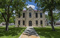
The Edwards County Courthouse in Rocksprings
|
|
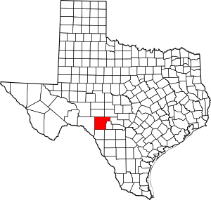
Location within the U.S. state of Texas
|
|
 Texas's location within the U.S. |
|
| Country | |
| State | |
| Founded | 1883 |
| Named for | Haden Edwards |
| Seat | Rocksprings |
| Largest town | Rocksprings |
| Area | |
| • Total | 2,120 sq mi (5,500 km2) |
| • Land | 2,118 sq mi (5,490 km2) |
| • Water | 2.0 sq mi (5 km2) 0.09% |
| Population
(2020)
|
|
| • Total | 1,422 |
| • Density | 0.6708/sq mi (0.2590/km2) |
| Time zone | UTC−6 (Central) |
| • Summer (DST) | UTC−5 (CDT) |
| Congressional district | 23rd |
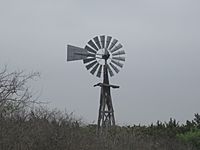
Edwards County is a county located in the state of Texas, USA. It sits on the Edwards Plateau, a high, flat area of land. In 2020, about 1,422 people lived there. The main town and county seat is Rocksprings.
The county was created in 1858 and officially started in 1883. It is named after Haden Edwards, an early settler in Nacogdoches, Texas. The famous Edwards Aquifer (a large underground water source) and the Edwards Plateau are also named after this county because of where they are located.
Contents
History
Edwards County has a long and interesting history.
- Long ago, the Lipan Apache and Comanche Native American tribes lived in this area.
- In 1762, a Lipan Apache chief asked Spanish missionaries and soldiers for help. They set up the San Lorenzo de la Santa Cruz Mission near the Nueces River. But this mission was closed in 1771.
- In 1825, Haden Harrison Edwards from Virginia worked with Stephen F. Austin to bring families to East Texas.
- In 1826, Edwards tried to create his own country called the Republic of Fredonia. This was an early attempt to break away from Mexico. Stephen F. Austin joined forces with Mexico against Edwards. Haden Edwards had to leave for Louisiana for a while in 1827. He later returned to Texas.
- Edwards County was officially formed from Bexar County in 1858.
- In 1871, two young brothers, Clint and Jeff Smith, were kidnapped by Native Americans near Rocksprings.
- W.J. Greer started a sheep camp in Rocksprings in 1882.
- In 1883, Edwards County was officially organized and named after Haden Harrison Edwards.
- The first cattle and sheep ranch in Rocksprings was started by Francis Winan in 1884.
- A.O. Burr began farming in Rocksprings in 1885.
- By 1891, Rocksprings became the county seat. The beautiful County Courthouse was built in a style called Romanesque Revival.
- The Rocksprings Telephone Company was started in 1898.
- In 1913, Edwards County lost some land on its eastern side to Real County.
- A powerful tornado hit Rocksprings in 1927.
- In 1940, Rocksprings was known as the "Top-o-the-World" for producing a lot of mohair, which is wool from Angora goats. This was their biggest year for it.
- Oil was found in the county in 1946.
- Kickapoo Cavern State Park opened to the public in 1991. It is a large park with caves, covering about 6,400 acres. It is located in both Edwards and Kinney County.
- Devil's Sinkhole State Natural Area opened near Rocksprings in 1992. It has the largest single-chambered cave in Texas and is the third deepest.
Geography
Edwards County covers a total area of about 2,120 square miles. Most of this is land, with only a small amount of water.
Major highways
These are the main roads that go through Edwards County:
Adjacent counties
Edwards County shares borders with these other counties:
- Sutton County (to the north)
- Kimble County (to the northeast)
- Kerr County (to the east)
- Real County (to the southeast)
- Uvalde County (to the southeast)
- Kinney County (to the south)
- Val Verde County (to the west)
Demographics
| Historical population | |||
|---|---|---|---|
| Census | Pop. | %± | |
| 1880 | 266 | — | |
| 1890 | 1,970 | 640.6% | |
| 1900 | 3,108 | 57.8% | |
| 1910 | 3,768 | 21.2% | |
| 1920 | 2,283 | −39.4% | |
| 1930 | 2,764 | 21.1% | |
| 1940 | 2,933 | 6.1% | |
| 1950 | 2,908 | −0.9% | |
| 1960 | 2,317 | −20.3% | |
| 1970 | 2,107 | −9.1% | |
| 1980 | 2,033 | −3.5% | |
| 1990 | 2,266 | 11.5% | |
| 2000 | 2,162 | −4.6% | |
| 2010 | 2,002 | −7.4% | |
| 2020 | 1,422 | −29.0% | |
| U.S. Decennial Census 1850–2010 2010 2020 |
|||
In 2000, there were 2,162 people living in Edwards County. The population density was very low, less than 1 person per square mile. The county is home to people from many different backgrounds. About 45% of the people were of Hispanic or Latino heritage.
The population includes people of all ages. In 2000, about 28.5% of the people were under 18 years old. About 16.2% were 65 years old or older. The average age was 39 years.
Communities
Town
- Rocksprings (This is the main town and where the county government is located.)
Census-designated places
- Barksdale (These are areas that are like towns but are not officially incorporated.)
Other unincorporated communities
- Carta Valley (These are smaller communities that are not officially part of a town or city.)
Education
Students in Edwards County attend schools in these districts:
- Rocksprings Independent School District
- Nueces Canyon Consolidated Independent School District
For college, the local community college is Southwest Texas Junior College.
See also
 In Spanish: Condado de Edwards (Texas) para niños
 | Kyle Baker |
 | Joseph Yoakum |
 | Laura Wheeler Waring |
 | Henry Ossawa Tanner |


