Val Verde County, Texas facts for kids
Quick facts for kids
Val Verde County
|
|
|---|---|
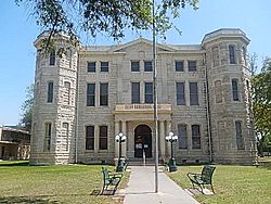
County courthouse
|
|
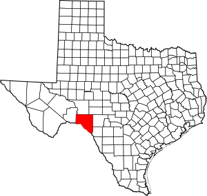
Location within the U.S. state of Texas
|
|
 Texas's location within the U.S. |
|
| Country | |
| State | |
| Founded | 1885 |
| Named for | Battle of Valverde |
| Seat | Del Rio |
| Largest city | Del Rio |
| Area | |
| • Total | 3,233 sq mi (8,370 km2) |
| • Land | 3,145 sq mi (8,150 km2) |
| • Water | 88 sq mi (230 km2) 2.7% |
| Population
(2020)
|
|
| • Total | 47,586 |
| • Density | 14.7188/sq mi (5.6830/km2) |
| Time zone | UTC−6 (Central) |
| • Summer (DST) | UTC−5 (CDT) |
| Congressional district | 23rd |
Val Verde County is a county located in the southern part of the Edwards Plateau in Texas, USA. In 2020, about 47,586 people lived there. Its main city, where the county government is, is Del Rio. The entire county is part of the Del Rio area, which is a smaller city region.
The name 'Val Verde' means "green valley" in Spanish. It was named after a battle during the American Civil War. In 1862, soldiers from Texas fought in the New Mexico Territory. They took part in the Battle of Valverde, where they captured several cannons. The county's name, and a small town in Milam County, remember this battle.
Contents
Exploring Val Verde County's Past
Early Inhabitants
The first people lived in what is now Val Verde County a very long time ago. They were here between 6,000 and 10,000 years ago. Their descendants include Native American groups like the Lipan Apache, Coahuiltecan, Jumano, Tamaulipan, and Comanche peoples.
Spanish Colonial Times
In 1590, a Spanish explorer named Gaspar Castaño de Sosa led a group of 170 people on a mining trip. They traveled through an area called Devils Draw. He mentioned a stream named Laxas, which people believe was the Devils River.
Later, in 1673, Juan Larios started a mission school between Del Rio and Eagle Pass. In 1675, Franciscan priests held a special church service at San Felipe Springs. In 1736, Lieutenant Miguel de la Garza Falcón led 100 soldiers along the Devils River. They were looking for Apache natives.
In 1834, James Grant and John Charles Beales tried to start a settlement on San Felipe Creek. However, it became dangerous because of attacks from Native American groups.
After the Mexican-American War
In the 1850s, the military built bases to protect against Native American attacks. These bases included Camp Blake, Camp Hudson, and Camp San Felipe. By 1860, the county had 2,874 people living there. This included 108 Black people and 1,103 people who were born in other countries.
After the Civil War
In 1868, the San Felipe Del Rio community was created. It was built on San Felipe Creek, right next to Camp San Felipe. From 1869 to 1882, a group called the Seminole Negro Indian Scouts helped protect the Texas border. They were led by John Lapham Bullis.
In 1883, the Galveston Harrisburg and San Antonio Railway was finished. This made travel and trade easier. An Italian immigrant named Frank Qualia also started the Val Verde winery that year.
The Langtry community was established in 1884. It was named after George Langtry, an engineer. Some people mistakenly thought it was named after the famous British entertainer Lillie Langtry by Judge Roy Bean.
In 1885, Val Verde County was officially formed from parts of Crockett, Kinney, and Pecos counties. Roy Bean became a justice of the peace in Langtry. He worked out of his saloon, the Jersey Lily, and became famous as "the Law West of the Pecos."
The communities of Juno and Devils River were established in 1886. In 1888, the Comstock community was founded, followed by Norris in 1889.
Twentieth Century Milestones
- 1928: Lake Hamilton Dam was completed.
- 1904: Lillie Langtry, the famous entertainer, visited the community of Langtry.
- 1929: Lake Walk Dam was completed.
- 1936: Val Verde County received a special historical marker, number 5625, to remember its founding.
- 1942: Laughlin Field, later called Laughlin Army Air Field, opened. It was used to train pilots during World War II.
- 1945: Laughlin Field closed after the war.
- 1952: Laughlin Field reopened as Laughlin Air Force Base. It was a secret base for U-2 spy planes. Major Rudolf Anderson, a U-2 pilot from Laughlin, was the only person killed during the Cuban Missile Crisis.
- 1969: The Amistad Dam and Reservoir project was finished. It cost $78 million.
Val Verde County's Geography
The U.S. Census Bureau says that Val Verde County covers a total area of 3,233 square miles. Most of this, 3,145 square miles, is land. The remaining 88 square miles (about 2.7%) are covered by water.
Main Roads and Highways
Neighboring Areas
Val Verde County shares borders with several other counties in Texas and two areas in Mexico:
- Crockett County (to the north)
- Sutton County (to the northeast)
- Edwards County (to the east)
- Kinney County (to the east)
- Terrell County (to the west)
- Acuña, Coahuila, Mexico (to the south)
- Jiménez, Coahuila, Mexico (to the south)
Protected Natural Areas
- Amistad National Recreation Area
- Rio Grande Wild and Scenic River (part of it)
People of Val Verde County
| Historical population | |||
|---|---|---|---|
| Census | Pop. | %± | |
| 1890 | 2,874 | — | |
| 1900 | 5,263 | 83.1% | |
| 1910 | 8,613 | 63.7% | |
| 1920 | 12,706 | 47.5% | |
| 1930 | 14,924 | 17.5% | |
| 1940 | 15,453 | 3.5% | |
| 1950 | 16,635 | 7.6% | |
| 1960 | 24,461 | 47.0% | |
| 1970 | 27,471 | 12.3% | |
| 1980 | 35,910 | 30.7% | |
| 1990 | 38,721 | 7.8% | |
| 2000 | 44,856 | 15.8% | |
| 2010 | 48,879 | 9.0% | |
| 2020 | 47,586 | −2.6% | |
| U.S. Decennial Census 1850–2010 2010 2020 |
|||
In 2000, there were 44,856 people living in Val Verde County. About 75.5% of the population was Hispanic or Latino. The county's population density was about 14 people per square mile.
Many households (42.90%) had children under 18 living with them. About 62.50% of households were married couples. The average household had 3.11 people. The average family had 3.55 people.
The median age in the county was 31 years old. This means half the people were younger than 31 and half were older. About 32.10% of the population was under 18 years old.
The median income for a household was $28,376. For a family, it was $31,434. About 26.10% of all people in the county lived below the poverty line. This included 33.80% of children under 18.
Learning and Education
Here are the school districts that serve Val Verde County:
- Comstock Independent School District
- Rocksprings Independent School District
- San Felipe-Del Rio Consolidated Independent School District
The Comstock district took in the Langtry and Pandale school districts before 1976. The Juno Common School District also joined Comstock ISD in 1992. There used to be a Star Route School on Miers Ranch, which had 13 students in 1964.
Southwest Texas Junior College is the community college for the county. The Val Verde County Library in Del Rio also serves the county, offering books and resources.
Communities in Val Verde County
City
- Del Rio (This is the county seat, meaning it's the main city where the county government is located.)
Census-Designated Places (CDPs)
These are areas that are like towns but are not officially incorporated as cities.
- Amistad
- Box Canyon
- Cienegas Terrace
- Lake View
- Laughlin Air Force Base
- Val Verde Park
Former CDPs
Unincorporated Communities
These are small communities that are not officially part of a city or a CDP.
Ghost Town
- Pumpville (A ghost town is a place where most people have left, and it's mostly empty now.)
Famous People from Val Verde County
See also
 In Spanish: Condado de Val Verde para niños
 | Emma Amos |
 | Edward Mitchell Bannister |
 | Larry D. Alexander |
 | Ernie Barnes |


