
Devils River (Texas) facts for kids

The Devils River is a very special river in southwestern Texas. It is part of the bigger Rio Grande river system. This river is known for its beautiful, clear water and wild areas.
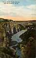
The Devils River starts in northwest Sutton County. Six smaller streams come together there to form the river. It flows southwest for about 94 miles (151 km) through Val Verde County. Finally, it flows into the Amistad Reservoir, a large lake on the Rio Grande near Del Rio, Texas. This area is very close to the Mexico border.
Many people consider the Devils River to be the most natural and untouched river in Texas. It is in a remote area, which means it doesn't get much pollution from people or farm animals. Also, part of the river flows underground! As it travels underground, the water gets cleaned by gravel, sand, and limestone. It then comes back to the surface about 20 miles (32 km) downstream, sparkling clean.
The Devils River Conservancy is a group that works to protect this amazing river. They want to make sure the Devils River stays healthy and beautiful for everyone in Texas, now and in the future. They also teach landowners and people who visit the river how to help protect it.
Contents
Fun Things to Do on the Devils River
The Devils River is a popular spot for kayaking and canoeing. However, it can be tricky to get to the river. This is because much of the land along the river is privately owned. But don't worry, a lot of the river is protected! Groups like The Nature Conservancy help protect the land along the river. Along with the Devils River State Natural Area, over 110,000 acres (445 sq km) of land along the river are kept safe.
Exploring the River by Boat
The Devils River is about 90 miles (145 km) long. But the upper part of the river often doesn't have enough water for boating. The best part for kayaking or canoeing is about 40 miles (64 km) long. This section goes from Bakers Crossing to the end point at Lake Amistad.
The most common place to start your trip is at Bakers Crossing, which is on Texas State Highway 163. You can find places to camp there and leave your car. Most of the river is pretty calm. It has mostly easy rapids (called Class 2) and some small, slightly harder ones (Class 3). You can learn more about rapids on the International Scale of River Difficulty.
It's important to know that the river's water level can change a lot. Even if it doesn't rain right where you are, rain in other areas can make the river rise or fall quickly.
Important Spots to Watch For
There are a couple of important spots to know about:
- Dolan Falls: This is a waterfall about 15 feet (4.6 m) tall. It's about 16.9 miles (27.2 km) into the trip. You must avoid this waterfall!
- Three Tier Rapids: About 19 miles (30.6 km) after Dolan Falls, you'll find Three Tier Rapids. This is usually a Class 4 rapid, which is quite difficult. If the river is high, it can even become a short Class 5 rapid! Only very experienced paddlers should try to go through this section.
You should always have a map when you're on the river. This is because Dolan Falls and Three Tier Rapids are hard to see until you are very close to them. After Three Tier Rapids, the river becomes much smoother. There are no more large rapids (over Class 3).
The river finally flows into Lake Amistad after about 40 miles (64 km) from Bakers Crossing. From there, it's another 12-mile (19 km) trip across the lake to the last take-out spot at Rough Canyon Marina. This part of the trip on the lake can be tiring, especially if there's a strong south wind.

What Makes the Devils River Special?
A big part of what makes the Devils River so appealing is how remote it is. The land around it is rugged and wild, and you won't see many people. For example, in the first 20 miles (32 km) of the river, you'll only see about five houses!
About 25 miles (40 km) into the trip, the Dry Devils River flows into the Devils River. Many people consider this the halfway point of the journey. There are more homes in this area, which is called the Blue Sage Subdivision.
Images for kids
-
Sunset Route, Castle Canyon, Texas (postcard, circa 1908)
