
Sutton County, Texas facts for kids
Quick facts for kids
Sutton County
|
|
|---|---|

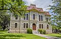
The Sutton County Courthouse in Sonora
|
|

Location within the U.S. state of Texas
|
|
 Texas's location within the U.S. |
|
| Country | |
| State | |
| Founded | 1890 |
| Named for | John S. Sutton |
| Seat | Sonora |
| Largest city | Sonora |
| Area | |
| • Total | 1,454 sq mi (3,770 km2) |
| • Land | 1,454 sq mi (3,770 km2) |
| • Water | 0.5 sq mi (1 km2) 0.03% |
| Population
(2020)
|
|
| • Total | 3,372 |
| • Density | 2.3191/sq mi (0.8954/km2) |
| Time zone | UTC−6 (Central) |
| • Summer (DST) | UTC−5 (CDT) |
| Congressional district | 23rd |


Sutton County is a place in the U.S. state of Texas. It is located on the Edwards Plateau, which is a high, flat area of land. In 2020, about 3,372 people lived there.
The main town and center of the county government is Sonora. Sutton County was officially created in 1887 and started its government in 1890. It is named after John S. Sutton, who was an officer in the Confederate States Army during the American Civil War.
Contents
History of Sutton County
Early Inhabitants and Explorers
Long ago, around 9500 BC, Paleo-Indians lived in the area that is now Sutton County. They left behind tools and signs of their camps. Later, other Native American groups like the Tonkawa, Comanche, and Lipan Apache also lived here.
In 1736, a Spanish officer named Lt. Miguel de la Garza Falcón led 100 soldiers through the area near the Devils River.
Protecting Settlers
In 1852, a place called Camp Terrett was set up. It was later known as Fort Terrett. Its job was to protect settlers from the Comanche people. It was founded by Lt. Col. Henry Bainbridge and named after Lt. John Terrett.
Founding Towns and Ranches
In 1881, Tim Birtrong and Ed Wall found a water source called Wall's Well. This led to the discovery of a town called Wentworth. At that time, the Birtrong Ranch was the only ranch in the area.
In 1885, Charles G. Adams started the town of Sonora, Texas. He named it after a family helper from Sonora, Mexico.
County Creation and Growth
In 1887, the Texas government officially created Sutton County. It was made from the eastern part of Crockett County. In 1890, Sonora became the official county seat, which means it was chosen as the main town for the county government.
Over the years, the county grew. In 1915, the Texas Sheep & Goat Raisers’ Association was formed. This group helped people who raised sheep and goats in the area. In 1928, a railway line connected Sonora to other cities like San Angelo and Del Rio. This made it easier to transport goods and people. The Sonora Wool and Mohair Company was started in 1930.
During the 1930s, projects from the Works Progress Administration (WPA) helped the local economy. The WPA was a government program that created jobs during the Great Depression.
Modern Developments
The Sonora Municipal Airport opened in 1958. A popular attraction, the Caverns of Sonora, opened to visitors in 1960. These caves were recognized as a National Natural Landmark in 1965 because of their unique beauty. In 1975, the Fort Terrett Ranch was bought by Bill Noël, a Texas oil businessman, who used part of it to grow pecans.
Geography of Sutton County
Sutton County covers about 1,454 square miles. Almost all of this area is land, with only a very small amount of water.
Main Roads
Two important highways pass through Sutton County:
 Interstate 10
 U.S. Highway 277
Neighboring Counties
Sutton County shares borders with several other counties:
- To the north: Schleicher County
- To the east: Kimble County
- To the south: Edwards County
- To the southwest: Val Verde County
- To the west: Crockett County
- To the northeast: Menard County
Population and People
| Historical population | |||
|---|---|---|---|
| Census | Pop. | %± | |
| 1890 | 658 | — | |
| 1900 | 1,727 | 162.5% | |
| 1910 | 1,569 | −9.1% | |
| 1920 | 1,598 | 1.8% | |
| 1930 | 2,807 | 75.7% | |
| 1940 | 3,977 | 41.7% | |
| 1950 | 3,746 | −5.8% | |
| 1960 | 3,738 | −0.2% | |
| 1970 | 3,175 | −15.1% | |
| 1980 | 5,130 | 61.6% | |
| 1990 | 4,135 | −19.4% | |
| 2000 | 4,077 | −1.4% | |
| 2010 | 4,128 | 1.3% | |
| 2020 | 3,372 | −18.3% | |
| U.S. Decennial Census 1850–2010 2010 2020 |
|||
In 2000, there were 4,077 people living in Sutton County. The population density was about 3 people per square mile. Many different groups of people live in the county. In 2000, about 50% of the population was Hispanic or Latino.
The average household in Sutton County had about 2.67 people. Many families lived together, with about 63.6% being married couples. About 38.2% of households had children under 18 living with them.
The median age in the county in 2000 was 36 years old. This means half the people were younger than 36 and half were older. About 28.8% of the population was under 18 years old.
Education in Sutton County
The schools in Sutton County are part of the Sonora Independent School District. This school district is based in Sonora.
Towns and Places
City
- Sonora (This is the main town and county seat.)
Old Towns (Ghost Towns)
Some towns that used to exist in Sutton County are now empty or abandoned. These are sometimes called "ghost towns."
Images for kids
-
The Sutton County Courthouse in Sonora
See also
 In Spanish: Condado de Sutton para niños
