Crockett County, Texas facts for kids
Quick facts for kids
Crockett County
|
|
|---|---|

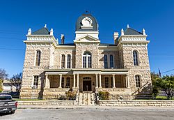
The Crockett County Courthouse in Ozona
|
|

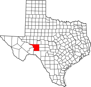
Location within the U.S. state of Texas
|
|
 Texas's location within the U.S. |
|
| Country | |
| State | |
| Founded | 1891 |
| Named for | Davy Crockett |
| Seat | Ozona |
| Largest community | Ozona |
| Area | |
| • Total | 2,807 sq mi (7,270 km2) |
| • Land | 2,807 sq mi (7,270 km2) |
| • Water | 0.02 sq mi (0.05 km2) 0.0% |
| Population
(2020)
|
|
| • Total | 3,098 |
| • Density | 1.1037/sq mi (0.42613/km2) |
| Time zone | UTC−6 (Central) |
| • Summer (DST) | UTC−5 (CDT) |
| Congressional district | 23rd |
Crockett County is a county in Texas, a state in the United States. It's located on a high area of land called the Edwards Plateau. In 2020, about 3,098 people lived there. The main town and county center is Ozona. The county was officially created in 1875 and set up in 1891. It is named after Davy Crockett, a famous American frontiersman who was a hero at the Battle of the Alamo.
Contents
History of Crockett County
Long ago, prehistoric people lived in places like Gobbler Shelter in Crockett County. The first known Native American tribes in this area were the Tonkawa, Lipan Apache, and Comanche.
In 1590, a Spanish explorer named Gaspar Castaño de Sosa led a group of 170 people through the western part of Crockett County. They were looking for mines and were heading towards the Pecos River. Later, in 1684, another explorer, Juan Domínguez de Mendoza, also crossed the Pecos River here.
In 1849, John Coffee Hays explored the area and mapped out water sources. Three years later, the U.S. Army decided to build a fort to protect travelers. Fort Lancaster was built in 1855. To help protect settlers, the Texas government sent Texas Rangers to the area in 1866.
Crockett County was officially formed on January 12, 1875. It was named after Davy Crockett. In 1887, some of its land was used to create Sutton and Schleicher counties. The first town in Crockett County was Emerald in 1889. In 1891, Crockett County was fully organized, and Ozona became its county seat. That same year, the first water well was drilled in Ozona.
Early settlers like W. P. Hoover arrived in 1885. Over the next ten years, many sheep and cattle ranchers settled in the county. The Kirkpatrick Hotel was built for people traveling by stagecoach and for cowboys. Stagecoach services began around 1900. The beautiful Crockett County Courthouse was built in 1902. It serves as a courthouse, county office, and even a community center.
In 1925, the first oil well in the area started producing oil on L. P. Powell's ranch. In 1938, Ozona put up a statue of Davy Crockett in the town square. The Crockett County Museum opened the next year to share the county's history.
Geography of Crockett County
Crockett County covers about 2,807 square miles. Almost all of this area is land.
Main Roads
 Interstate 10
 U.S. Highway 190
 State Highway 137
 State Highway 163
 State Highway 349
Neighboring Counties
Crockett County borders many other counties. These include:
- Upton County (north)
- Reagan County (north)
- Irion County (northeast)
- Schleicher County (east)
- Sutton County (east)
- Val Verde County (south)
- Terrell County (south)
- Pecos County (west)
- Crane County (northwest)
Crockett County is one of the few counties in the United States that borders as many as nine other counties!
Population of Crockett County
A census is a count of all the people living in an area. It happens every ten years. Here's how the population of Crockett County has changed over time:
| Historical population | |||
|---|---|---|---|
| Census | Pop. | %± | |
| 1880 | 127 | — | |
| 1890 | 194 | 52.8% | |
| 1900 | 1,591 | 720.1% | |
| 1910 | 1,296 | −18.5% | |
| 1920 | 1,500 | 15.7% | |
| 1930 | 2,590 | 72.7% | |
| 1940 | 2,809 | 8.5% | |
| 1950 | 3,981 | 41.7% | |
| 1960 | 4,209 | 5.7% | |
| 1970 | 3,885 | −7.7% | |
| 1980 | 4,608 | 18.6% | |
| 1990 | 4,078 | −11.5% | |
| 2000 | 4,099 | 0.5% | |
| 2010 | 3,719 | −9.3% | |
| 2020 | 3,098 | −16.7% | |
| U.S. Decennial Census 1850–2010 2010 2020 |
|||
Here is a table showing the different groups of people living in Crockett County:
| Race / Ethnicity (NH = Non-Hispanic) | Pop 2000 | Pop 2010 | Pop 2020 | % 2000 | % 2010 | % 2020 |
|---|---|---|---|---|---|---|
| White alone (NH) | 1,792 | 1,312 | 1,080 | 43.72% | 35.28% | 34.86% |
| Black or African American alone (NH) | 18 | 13 | 18 | 0.44% | 0.35% | 0.58% |
| Native American or Alaska Native alone (NH) | 17 | 8 | 9 | 0.41% | 0.22% | 0.29% |
| Asian alone (NH) | 10 | 11 | 10 | 0.24% | 0.30% | 0.32% |
| Pacific Islander alone (NH) | 0 | 0 | 0 | 0.00% | 0.00% | 0.00% |
| Other race alone (NH) | 4 | 4 | 9 | 0.10% | 0.11% | 0.29% |
| Mixed race or Multiracial (NH) | 16 | 19 | 52 | 0.39% | 0.51% | 1.68% |
| Hispanic or Latino (any race) | 2,242 | 2,352 | 1,920 | 54.70% | 63.24% | 61.98% |
| Total | 4,099 | 3,719 | 3,098 | 100.00% | 100.00% | 100.00% |
In 2000, there were 4,099 people living in the county. The population density was about 1.46 people per square mile. About 54.70% of the people were of Hispanic or Latino background. The median age was 37 years old.
Communities in Crockett County
Towns and Places
- Ozona (This is the county seat, meaning it's the main town where the county government is located.)
Old Towns
- Emerald (This is a "ghost town," meaning it was once a town but is now mostly abandoned.)
See also
 In Spanish: Condado de Crockett (Texas) para niños
 | Georgia Louise Harris Brown |
 | Julian Abele |
 | Norma Merrick Sklarek |
 | William Sidney Pittman |

