Irion County, Texas facts for kids
Quick facts for kids
Irion County
|
|
|---|---|

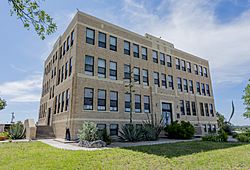
The Irion County Courthouse in Mertzon
|
|

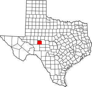
Location within the U.S. state of Texas
|
|
 Texas's location within the U.S. |
|
| Country | |
| State | |
| Founded | 1889 |
| Named for | Robert Anderson Irion |
| Seat | Mertzon |
| Largest city | Mertzon |
| Area | |
| • Total | 1,052 sq mi (2,720 km2) |
| • Land | 1,052 sq mi (2,720 km2) |
| • Water | 0.07 sq mi (0.2 km2) 0.01% |
| Population
(2020)
|
|
| • Total | 1,513 |
| • Density | 1.4382/sq mi (0.5553/km2) |
| Time zone | UTC−6 (Central) |
| • Summer (DST) | UTC−5 (CDT) |
| Congressional district | 11th |
Irion County is a county in the state of Texas. It is located on the Edwards Plateau, a high, flat area of land. In 2020, about 1,513 people lived there.
The main town and county seat of Irion County is Mertzon. The county is named after Robert Anderson Irion. He was a secretary of state for the Republic of Texas, which was an independent country before Texas joined the United States. Irion County is part of the larger San Angelo area.
Contents
History of Irion County
Many years ago, from 1858 to 1861, the Butterfield Overland Mail route passed through this area. This was a famous stagecoach service that carried mail and passengers across the country.
In 1876, John Arden brought the first group of sheep to the county. Around the same time, Billy Childress started the Longhorn 7D Ranch.
The Texas Legislature officially created Irion County in 1889. It was formed from parts of Tom Green County. The first county seat was a town called Sherwood.
An important discovery happened in 1928 when oil was found in Irion County. This helped the county grow. Later, in 1936, Mertzon became the new county seat.
Today, the Old Irion County Courthouse in Sherwood is a special historical building. It is the only place in the county listed on the National Register of Historic Places. This means it is recognized as an important historical site.
Geography of Irion County
Irion County covers a total area of about 1,052 square miles. Almost all of this area is land. Only a very small part, about 0.07 square miles, is water.
A large underground oil field called the Spraberry Trend is beneath much of the county. This is one of the biggest oil fields in the United States.
Main Roads in Irion County
Neighboring Counties
Irion County shares its borders with several other counties:
- Tom Green County (to the north and east)
- Schleicher County (to the southeast)
- Crockett County (to the southwest)
- Reagan County (to the west)
Population of Irion County
| Historical population | |||
|---|---|---|---|
| Census | Pop. | %± | |
| 1890 | 870 | — | |
| 1900 | 848 | −2.5% | |
| 1910 | 1,283 | 51.3% | |
| 1920 | 1,610 | 25.5% | |
| 1930 | 2,049 | 27.3% | |
| 1940 | 1,963 | −4.2% | |
| 1950 | 1,590 | −19.0% | |
| 1960 | 1,183 | −25.6% | |
| 1970 | 1,070 | −9.6% | |
| 1980 | 1,386 | 29.5% | |
| 1990 | 1,629 | 17.5% | |
| 2000 | 1,771 | 8.7% | |
| 2010 | 1,599 | −9.7% | |
| 2020 | 1,513 | −5.4% | |
| U.S. Decennial Census 1850–2010 2010 2020 |
|||
The population of Irion County has changed over the years. In 1890, there were 870 people. The population grew to over 2,000 people by 1930. Since then, it has slowly decreased. In 2020, the county had 1,513 residents.
Most people in Irion County are White. A smaller number of people are Hispanic or Latino. There are also smaller groups of Black or African American, Native American, and Asian people.
Towns and Communities
Famous People from Irion County
- Laura Bullion: She was an Old West outlaw who was born in Knickerbocker, a community in Irion County.
See also
 In Spanish: Condado de Irion para niños
 | DeHart Hubbard |
 | Wilma Rudolph |
 | Jesse Owens |
 | Jackie Joyner-Kersee |
 | Major Taylor |

