Upton County, Texas facts for kids
Quick facts for kids
Upton County
|
|
|---|---|

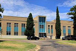
The Upton County Courthouse in Rankin
|
|

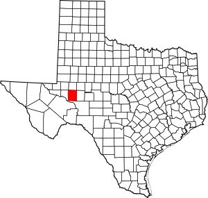
Location within the U.S. state of Texas
|
|
 Texas's location within the U.S. |
|
| Country | |
| State | |
| Founded | 1910 |
| Seat | Rankin |
| Largest city | McCamey |
| Area | |
| • Total | 1,242 sq mi (3,220 km2) |
| • Land | 1,241 sq mi (3,210 km2) |
| • Water | 0.2 sq mi (0.5 km2) 0.01% |
| Population
(2020)
|
|
| • Total | 3,308 |
| • Density | 2.6634/sq mi (1.0284/km2) |
| Time zone | UTC−6 (Central) |
| • Summer (DST) | UTC−5 (CDT) |
| Congressional district | 23rd |
Upton County is a county located in the state of Texas. It is found on the Edwards Plateau. In 2020, about 3,308 people lived there. The main town and county seat is Rankin.
Upton County was created in 1887. It was officially organized in 1910. The county is named after two brothers, John C. and William F. Upton. They were colonels during the American Civil War.
Contents
History of Upton County
Early Inhabitants: Native Americans
Native Americans were the first people to live in this area. Tribes like the Comanches and Apache lived here long ago.
Important Trails
Many important paths crossed through Upton County. These trails helped people travel and trade.
- The Chihuahua Trail connected Chihuahua, Mexico, with Santa Fe, New Mexico. It was a trade route for Native American tribes, Spaniards, and traders.
- The Butterfield Overland Mail route passed through the area from 1858 to 1861. This was a way to deliver mail across the country.
- The Goodnight-Loving Trail was used to move cattle from 1866 to 1888. It started in Young County, Texas, followed the Pecos River, and went all the way to Cheyenne, Wyoming.
How the County Was Formed
Upton County was created in 1887. It was formed from parts of Tom Green County, Texas. The county got its name from John C. Upton and William F. Upton.
The first person to set up a home in Upton County was George Elliott in 1880. He was a cattleman. At first, the land was open for cattle and sheep. By the 1890s, sheep ranchers also used the land.
In 1890, only 52 people lived in the county. By 1900, there were only 48. Most of these people were part of three families or worked for them. Ranching became much more important than farming. In 1982, most of the land was used for farms and ranches. However, very little of it was good for growing crops.
In 1911, a railway line reached the town of Rankin. By 1912, many people from other parts of the county moved to Rankin.
The Oil Boom
Oil changed Upton County a lot. In September 1925, George McCamey found oil. This led to the creation of the McCamey Oil Field. It also started the town of McCamey and brought a big oil boom to the county.
The Yates Oil Field in nearby counties also helped Rankin. Rankin became a center for supplies and services for the oil industry. This brought a lot of money to Rankin, which helped build better roads and buildings.
In 1946, Mike Benedum found more oil in Upton County. This area became known as the Benedum Oil Field. In 1961, another well called Weir No. 1 started producing oil. This helped Upton County remain an important oil-producing area in Texas.
Geography of Upton County
Upton County covers about 1,242 square miles. Only a tiny part of this area is covered by water.
A very large oil field called the Spraberry Trend is located under much of the county. It is one of the biggest oil fields in the United States. The highest point in Upton County is Bobcat Hills. It is about 2,697 feet tall.
Main Roads
These are the major highways that go through Upton County:
Neighboring Counties
Upton County shares borders with these other counties:
- Midland County (north)
- Reagan County (east)
- Crockett County (south)
- Crane County (west)
- Ector County (northwest)
Population Information
| Historical population | |||
|---|---|---|---|
| Census | Pop. | %± | |
| 1890 | 52 | — | |
| 1900 | 48 | −7.7% | |
| 1910 | 501 | 943.8% | |
| 1920 | 253 | −49.5% | |
| 1930 | 5,968 | 2,258.9% | |
| 1940 | 4,297 | −28.0% | |
| 1950 | 5,307 | 23.5% | |
| 1960 | 6,239 | 17.6% | |
| 1970 | 4,697 | −24.7% | |
| 1980 | 4,619 | −1.7% | |
| 1990 | 4,447 | −3.7% | |
| 2000 | 3,404 | −23.5% | |
| 2010 | 3,355 | −1.4% | |
| 2020 | 3,308 | −1.4% | |
| U.S. Decennial Census 1850–2010 2010 2020 |
|||
In 2000, there were 3,404 people living in Upton County. There were 1,256 households and 934 families. The population density was about 3 people per square mile.
Most people in the county were White (77.79%). About 42.57% of the population was Hispanic or Latino.
In 2000, about 36.30% of households had children under 18. Most households (61.10%) were married couples. The average household had 2.68 people.
The median age in the county was 38 years old. This means half the people were older than 38, and half were younger.
Towns and Communities
Cities
Other Communities
- Midkiff (This is a small community that is not officially a city)
Old Towns (Ghost Towns)
- Upland (This town no longer exists)
Education
Students in Upton County attend schools in different districts:
- Grandfalls-Royalty Independent School District
- Monahans-Wickett-Pyote Independent School District
- Pecos-Barstow-Toyah Independent School District
Everyone in the county can also get services from Odessa College.
Images for kids
See also
 In Spanish: Condado de Upton para niños
 | Charles R. Drew |
 | Benjamin Banneker |
 | Jane C. Wright |
 | Roger Arliner Young |


