Terrell County, Texas facts for kids
Quick facts for kids
Terrell County
|
||
|---|---|---|

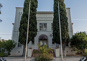
Terrell County Courthouse in Sanderson.
|
||
|
||

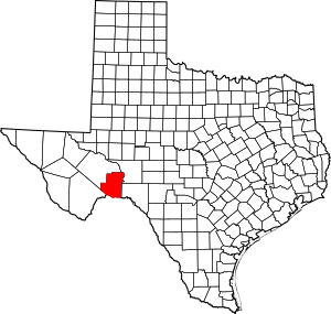
Location within the U.S. state of Texas
|
||
 Texas's location within the U.S. |
||
| Country | ||
| State | ||
| Founded | 1905 | |
| Named for | Alexander W. Terrell | |
| Seat | Sanderson | |
| Largest community | Sanderson | |
| Area | ||
| • Total | 2,358 sq mi (6,110 km2) | |
| • Land | 2,358 sq mi (6,110 km2) | |
| • Water | 0.04 sq mi (0.1 km2) 0% | |
| Population
(2020)
|
||
| • Total | 760 | |
| • Estimate
(2022)
|
693 |
|
| • Density | 0.3223/sq mi (0.1244/km2) | |
| Time zone | UTC−6 (Central) | |
| • Summer (DST) | UTC−5 (CDT) | |
| Congressional district | 23rd | |
Terrell County is a county located in the U.S. state of Texas. In 2020, about 760 people lived there. This makes it one of the least populated counties in Texas and the United States. The main town and county seat is Sanderson. There are no other official cities in the county.
The county is named after Alexander W. Terrell, who was a state senator in Texas. Terrell County is part of the Trans-Pecos region in West Texas. It is also famous for being the setting of the book No Country for Old Men by Cormac McCarthy, which was later made into a movie.
Contents
History
Early People
Long ago, Native Americans lived in Terrell County. We know this because people have found arrowheads, tools, and special cooking spots called middens. They also found caves and shelters with pictures drawn on the walls by these early people. Inside the caves, pieces of reed sandals, baskets, and even signs of burials have been discovered. The most cave drawings are found near Myers Spring, close to Dryden. Different layers of paintings suggest that various Native American groups lived there over time.
First Explorers
In 1729, Captain José de Berroterán led a Spanish group to explore the area near the Rio Grande. Legend says he placed a large wooden cross near a spring in Dryden. Six years later, another Spanish explorer, Blas María de la Garza Falcón, found the cross and named the spot Santa Cruz de Maya.
Later, in 1848, Captain Samuel Highsmith traveled through the county. He was trying to find a new road from San Antonio to El Paso. In 1851, Army officer Lt. Nathaniel Michler mapped this area, which was the border between Mexico and the United States. Even U.S. Camel Corps caravans, using camels, crossed the county in 1859, looking for a shorter way to Fort Davis.
County Starts and Grows
Terrell County was officially created in 1905 by the Texas Legislature. It was formed from a large part of Pecos County. Sanderson became the county seat that same year. Sanderson was first called Strawbridge. It was named after railroad engineer Joseph P. Sanderson.
The railroad, cattle, and sheep industries were very important for the county's economy. Charles Downie, a man from Scotland, started the first permanent sheep ranch in 1881. Terrell County became one of the biggest sheep and wool producers in the U.S. Thousands of pounds of wool and mohair were sold every year. Dryden, another town started in 1882, was once a big shipping point for cattle. Today, Dryden is mostly a ghost town.
After 1957, the oil and gas industry became important when the Brown-Bassett gas field was found. Gas was the main product until the 1970s, when oil production also began.
On June 11, 1965, a large flood hit Sanderson, causing a lot of damage and affecting many lives. In 1999, the Texas State Senate declared Sanderson and Terrell County the "Cactus Capital of Texas."
Geography
Terrell County covers about 2,358 square miles (6,107 square kilometers) of land.
Main Roads
Neighboring Areas
- Pecos County (north)
- Crockett County (north)
- Val Verde County (east)
- Brewster County (southwest)
- Acuña, Coahuila, Mexico (south)
Protected Areas
- Rio Grande Wild and Scenic River (part of it is in the county)
Climate
Most of Terrell County has a semiarid steppe climate. This means it's usually dry with hot summers. Some parts of the county also have a hot arid desert climate.
- Dryden
- Coordinates: 30°03′00″N 102°07′00″W / 30.05000°N 102.11667°W
- Elevation: 2,190 feet (668 m)
| Climate data for Dryden, Texas (Jun 1, 1966–Oct 31, 1994) | |||||||||||||
|---|---|---|---|---|---|---|---|---|---|---|---|---|---|
| Month | Jan | Feb | Mar | Apr | May | Jun | Jul | Aug | Sep | Oct | Nov | Dec | Year |
| Mean daily maximum °F (°C) | 60.2 (15.7) |
65.0 (18.3) |
74.3 (23.5) |
82.7 (28.2) |
88.8 (31.6) |
94.5 (34.7) |
95.5 (35.3) |
94.8 (34.9) |
88.8 (31.6) |
79.9 (26.6) |
69.2 (20.7) |
61.8 (16.6) |
79.6 (26.5) |
| Mean daily minimum °F (°C) | 32.7 (0.4) |
36.0 (2.2) |
44.0 (6.7) |
53.4 (11.9) |
61.6 (16.4) |
68.6 (20.3) |
70.6 (21.4) |
69.4 (20.8) |
63.8 (17.7) |
52.6 (11.4) |
41.7 (5.4) |
33.8 (1.0) |
52.4 (11.3) |
| Average precipitation inches (mm) | 0.53 (13) |
1.03 (26) |
0.57 (14) |
0.99 (25) |
1.75 (44) |
1.02 (26) |
1.27 (32) |
1.85 (47) |
2.64 (67) |
1.40 (36) |
0.74 (19) |
0.45 (11) |
14.24 (360) |
| Source: Western Regional Climate Center, Desert Research Institute | |||||||||||||
- Sanderson
- Coordinates: 30°08′29″N 102°23′30″W / 30.14139°N 102.39167°W
- Elevation: 2,788 feet (850 m)
| Climate data for Sanderson, Texas (Jan 1, 1897–Mar 31, 2013) | |||||||||||||
|---|---|---|---|---|---|---|---|---|---|---|---|---|---|
| Month | Jan | Feb | Mar | Apr | May | Jun | Jul | Aug | Sep | Oct | Nov | Dec | Year |
| Mean daily maximum °F (°C) | 60.8 (16.0) |
64.5 (18.1) |
72.9 (22.7) |
81.5 (27.5) |
87.3 (30.7) |
92.0 (33.3) |
92.6 (33.7) |
92.4 (33.6) |
86.9 (30.5) |
78.8 (26.0) |
69.2 (20.7) |
61.3 (16.3) |
78.4 (25.8) |
| Mean daily minimum °F (°C) | 31.4 (−0.3) |
34.8 (1.6) |
42.3 (5.7) |
51.7 (10.9) |
60.2 (15.7) |
67.3 (19.6) |
69.4 (20.8) |
68.4 (20.2) |
62.3 (16.8) |
51.4 (10.8) |
40.2 (4.6) |
32.3 (0.2) |
51.0 (10.5) |
| Average precipitation inches (mm) | 0.46 (12) |
0.54 (14) |
0.42 (11) |
0.79 (20) |
1.62 (41) |
1.73 (44) |
1.42 (36) |
1.50 (38) |
2.14 (54) |
1.49 (38) |
0.59 (15) |
0.42 (11) |
13.12 (334) |
| Source: Western Regional Climate Center, Desert Research Institute | |||||||||||||
People and Population
| Historical population | |||
|---|---|---|---|
| Census | Pop. | %± | |
| 1910 | 1,430 | — | |
| 1920 | 1,595 | 11.5% | |
| 1930 | 2,660 | 66.8% | |
| 1940 | 2,952 | 11.0% | |
| 1950 | 3,189 | 8.0% | |
| 1960 | 2,600 | −18.5% | |
| 1970 | 1,940 | −25.4% | |
| 1980 | 1,595 | −17.8% | |
| 1990 | 1,410 | −11.6% | |
| 2000 | 1,081 | −23.3% | |
| 2010 | 984 | −9.0% | |
| 2020 | 760 | −22.8% | |
| 2022 (est.) | 693 | −29.6% | |
| U.S. Decennial Census 1850–2010 2010-2020 |
|||
The population of Terrell County has changed over the years. In 2010, there were 984 people living there. By 2020, the population was 760.
The table below shows the different groups of people living in Terrell County over time. It separates people by race and whether they are of Hispanic or Latino origin.
| Race / Ethnicity (NH = Non-Hispanic) | Pop 2000 | Pop 2010 | Pop 2020 | % 2000 | % 2010 | % 2020 |
|---|---|---|---|---|---|---|
| White alone (NH) | 529 | 495 | 352 | 48.94% | 50.30% | 46.32% |
| Black or African American alone (NH) | 0 | 6 | 8 | 0.00% | 0.61% | 1.05% |
| Native American or Alaska Native alone (NH) | 18 | 7 | 0 | 1.67% | 0.71% | 0.00% |
| Asian alone (NH) | 7 | 4 | 5 | 0.65% | 0.41% | 0.66% |
| Pacific Islander alone (NH) | 0 | 0 | 0 | 0.00% | 0.00% | 0.00% |
| Other race alone (NH) | 1 | 0 | 2 | 0.09% | 0.00% | 0.26% |
| Mixed race or Multiracial (NH) | 1 | 5 | 23 | 0.09% | 0.51% | 3.03% |
| Hispanic or Latino (any race) | 525 | 467 | 370 | 48.57% | 47.46% | 48.68% |
| Total | 1,081 | 984 | 760 | 100.00% | 100.00% | 100.00% |
In 2010, about 84% of the people were White, and about 47.5% were Hispanic or Latino. The median age was 42 years old.
Communities
Former Communities
- Cedar Station
See also
 In Spanish: Condado de Terrell (Texas) para niños
 | Emma Amos |
 | Edward Mitchell Bannister |
 | Larry D. Alexander |
 | Ernie Barnes |


