
Brewster County, Texas facts for kids
Quick facts for kids
Brewster County
|
|
|---|---|

The Brewster County Courthouse in Alpine
|
|

Location within the U.S. state of Texas
|
|
 Texas's location within the U.S. |
|
| Country | |
| State | |
| Founded | 1887 |
| Named for | Henry Percy Brewster |
| Seat | Alpine |
| Largest city | Alpine |
| Area | |
| • Total | 6,192 sq mi (16,040 km2) |
| • Land | 6,184 sq mi (16,020 km2) |
| • Water | 8.5 sq mi (22 km2) 0.1%% |
| Population
(2020)
|
|
| • Total | 9,546 |
| • Density | 1.5/sq mi (0.6/km2) |
| Time zone | UTC−6 (Central) |
| • Summer (DST) | UTC−5 (CDT) |
| Congressional district | 23rd |
Brewster County is a large county in the state of Texas. It's in West Texas, and its main city, Alpine, is also the county seat. Brewster County is part of the Trans-Pecos region and shares a border with Mexico.
Brewster County is the biggest county in Texas by land area. It covers about 6,192 square miles (16,040 km2). This makes it larger than the states of Delaware and Connecticut combined! In 2020, about 9,546 people lived here. The county is named after Colonel Henry Percy Brewster. He was a Secretary of War for the old Republic of Texas.
Contents
A Look at Brewster County's History
Who Lived Here First?
Paleo-Indian hunter-gatherers lived in this area at least 9,000 years ago. Later, the Mescalero Apaches arrived. They often raided the area, which made it hard for new settlers.
Between 1779 and 1787, a Spanish leader named Col. Juan de Ugalde pushed the Mescaleros north. They went across the Rio Grande and into the Chisos Mountains. In 1789, three main Mescalero chiefs agreed to follow Spanish rule. Comanche raiding parties continued to be active through the 1800s.
Early Explorers and Visitors

Spanish explorers crossed Brewster County long ago. Álvar Núñez Cabeza de Vaca came through in 1535. Antonio de Espejo followed in 1583. They were on their way to where the Rio Grande and Rio Conchos meet.
In 1684, Juan Domínguez de Mendoza camped at Kokernot Spring. He wrote the first known description of this spot. Later, in the 1740s, Pedro de Rábago y Terán, a governor, led an expedition here.
In 1851, a Danish-born Mexican commander, Col. Edvard Emil Langberg, visited southern Brewster County. The next year, a surveyor named William H. Emory sent M. T. W. Chandler to explore the area. Chandler explored places like Santa Elena Canyon and the Chisos Mountains.
Even the U.S. Camel Corps explored the area! In 1859, an expedition with camels explored the Comanche Trail. A year later, another camel group explored along the Rio Grande.
How Brewster County Was Formed

Brewster County was officially created in 1887. It was separated from Presidio County. The county was named after Henry Percy Brewster. Murphyville, which later became Alpine, was chosen as the county seat.
To protect against ongoing Native American attacks, Camp Peña Colorado was set up in 1879. It was a few miles south of where Marathon would later be.
News about the open land spread, bringing in more settlers. The Galveston, Harrisburg and San Antonio Railway built tracks through the area in 1882. This brought new opportunities and people who decided to stay.
Alfred S. Gage moved here in 1882 to help with his brother's ranch. He started the A. S. Gage Ranch in 1883, which became one of the biggest ranches in Texas. He also built the Gage Hotel in Marathon in 1927.
James B. Gillett, a famous lawman and Texas Ranger, was sheriff of Brewster County. He also ran a ranch in Alpine in the late 1800s and early 1900s.
Joseph Daniel Jackson came in 1882 as part of the Texas Rangers. He was there to protect the railroad. He later became a rancher, merchant, and community leader. Jackson is known as the "father" of Sul Ross University. He worked hard to help establish the school. Sul Ross University was created in 1917 to train teachers.
Growing Population and Industries
The county's population grew a lot between 1890 and 1910. It went from 710 people to 5,220. This growth was mostly due to industries that used natural resources.
From the early 1900s until World War II, the Terlingua Mining District was a busy place. It was west of the Chisos Mountains. People mined cinnabar there, which is an ore used to get mercury. Silver and lead were also shipped from mines across the border in Mexico. Other products included candelilla wax and guayule rubber.
Border Challenges and Pancho Villa
Brewster County faced attacks from bandits from Mexico. These attacks were partly inspired by Pancho Villa. In 1915, Governor James E. Ferguson asked President Woodrow Wilson to send troops to the Big Bend area.
A major event was the raid at Glenn Spring on May 5, 1916. Only nine soldiers were stationed there. Many Mexican raiders attacked them. This raid led to a much larger military presence. President Wilson sent the National Guard to help the Army. By the end of 1916, many guardsmen were along the border. After World War I, the mining and wax factories slowed down, and the raids from across the border also stopped.
The Big Bend Area
The Big Bend is a special part of the Trans-Pecos region. It's known for its rough, dry Chihuahuan Desert landscape. The area gets its name from a sharp turn the Rio Grande makes nearby.
Big Bend National Park was first created as a state park in 1933. The United States Congress made it a national park in 1935. Big Bend opened to the public in 1944. It's one of the largest national parks in the U.S. It covers over 800,000 acres, which is bigger than the state of Rhode Island.
Big Bend Ranch State Park opened in 1991. It's partly in Presidio County. At 300,000 acres, it is the largest state park in Texas.
Terlingua Chili Cookoffs
Terlingua was once a boom town for mercury mining. But its population dropped, and it became a ghost town. In 1962, a newspaper writer named Frank X. Tolbert wrote a book about chili. He also started the Chili Appreciation Society.
The World Championship Chili Cookoff at Terlingua began in 1967. It started as a friendly challenge between Tolbert and another writer. Now, it's a yearly tradition in November. Terlingua hosts two big international chili championships on the first Saturday of November.
Geography and Natural Wonders
Brewster County has a total area of about 6,192 square miles (16,040 km2). Most of this is land, with only a small amount of water. It is the largest county in Texas by area. The only major water source is half the width of the Rio Grande.
The county's area is larger than the combined area of Delaware and Rhode Island. It is also larger than the individual states of Connecticut, Delaware, and Rhode Island.
Some geological ages are named after places in the county. The Roadian Age is named for Road Canyon. The Wordian Age is probably named for the Word Ranch in the Glass Mountains.
Nearby Counties and Cities

Brewster County is bordered by:
- Pecos County (north)
- Terrell County (east)
- Acuña, Coahuila, Mexico (southeast and south)
- Ocampo, Coahuila, Mexico (south)
- Manuel Benavides, Chihuahua, Mexico (southwest)
- Presidio County (west)
- Jeff Davis County (northwest)
Protected Natural Areas
- Big Bend National Park
- Rio Grande Wild and Scenic River (part)
Main Roads and Railways
 U.S. Highway 67
 U.S. Highway 90
 U.S. Highway 385
 State Highway 118
U.S. Highway 90 crosses the northern part of the county. U.S. Highway 385 goes south to Big Bend National Park. The Sunset Route of the Union Pacific Railroad also crosses the northern county. A part of the Kansas City, Mexico and Orient Railway goes through the county towards Presidio.
Climate in Brewster County
Brewster County has a mostly hot, dry desert climate. Some areas have a semi-arid steppe climate. Temperatures are cooler and there's more rain in the northern highlands. The Chisos Mountains also get more rain. In the southern lowlands along the Rio Grande, it's very hot in summer. Snow is rare there, and it rains less. Most of the rain falls from May through October. The rest of the year is usually dry.
People and Population
| Historical population | |||
|---|---|---|---|
| Census | Pop. | %± | |
| 1890 | 710 | — | |
| 1900 | 2,356 | 231.8% | |
| 1910 | 5,220 | 121.6% | |
| 1920 | 4,822 | −7.6% | |
| 1930 | 6,624 | 37.4% | |
| 1940 | 6,478 | −2.2% | |
| 1950 | 7,309 | 12.8% | |
| 1960 | 6,434 | −12.0% | |
| 1970 | 7,780 | 20.9% | |
| 1980 | 7,573 | −2.7% | |
| 1990 | 8,681 | 14.6% | |
| 2000 | 8,866 | 2.1% | |
| 2010 | 9,232 | 4.1% | |
| 2020 | 9,546 | 3.4% | |
| U.S. Decennial Census 1850–2010 2010–2020 |
|||
What the 2020 Census Shows
| Race / Ethnicity (NH = Non-Hispanic) | Pop 2000 | Pop 2010 | Pop 2020 | % 2000 | % 2010 | % 2020 |
|---|---|---|---|---|---|---|
| White alone (NH) | 4,710 | 5,011 | 4,948 | 53.12% | 54.28% | 51.83% |
| Black or African American alone (NH) | 87 | 79 | 162 | 0.98% | 0.86% | 1.70% |
| Native American or Alaska Native alone (NH) | 63 | 38 | 30 | 0.71% | 0.41% | 0.31% |
| Asian alone (NH) | 27 | 58 | 94 | 0.30% | 0.63% | 0.98% |
| Pacific Islander alone (NH) | 2 | 5 | 11 | 0.02% | 0.05% | 0.12% |
| Other race alone (NH) | 10 | 11 | 56 | 0.11% | 0.12% | 0.59% |
| Mixed race or Multiracial (NH) | 100 | 112 | 282 | 1.13% | 1.21% | 2.95% |
| Hispanic or Latino (any race) | 3,867 | 3,918 | 3,963 | 43.62% | 42.44% | 41.51% |
| Total | 8,866 | 9,232 | 9,546 | 100.00% | 100.00% | 100.00% |
In 2020, there were 9,546 people living in Brewster County. There were 4,292 households and 2,300 families. The population included people of various backgrounds. About 51.8% were non-Hispanic White. About 41.5% were Hispanic or Latino.
Education in Brewster County

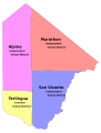
Several school districts serve Brewster County:
- Alpine Independent School District (Alpine High School)
- Marathon Independent School District
- San Vicente Independent School District (up to 8th grade only; high schoolers go to Terlingua CSD)
- Terlingua Common School District (Big Bend High School)
Also, Sul Ross State University is located in Alpine. For community college, Brewster County is part of the Odessa College District.
Communities in Brewster County
Cities
- Alpine (This is the county seat.)
Census-Designated Places
These are areas identified by the census for statistics:
Other Communities
Old Ghost Towns
These are places where people used to live but are now mostly abandoned:
- Castolon
- Glenn Springs
- Haymond
- Hovey
- McKinney Springs
- San Vicente
- Toronto
County Sheriff's Office
The Brewster County Sheriff's Office is based in Alpine. The current elected Sheriff is Ronny Dodson. This office patrols and investigates crimes throughout the county, including in Alpine.
Images for kids
-
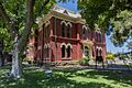
The Brewster County Courthouse in Alpine
-
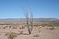
Chihuahuan Desert landscape in Brewster County
-
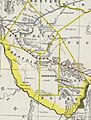
Map of Presidio County, Texas and the counties of Brewster, Buchel, Foley, and Jeff Davis created from Presidio in 1887. Buchel and Foley were later joined to Brewster in 1897.
-
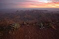
Sunset in Big Bend National Park
-
Map of Brewster County, Texas with school district boundaries
See also
 In Spanish: Condado de Brewster para niños
