
Presidio County, Texas facts for kids
Quick facts for kids
Presidio County
|
|
|---|---|

Presidio County Courthouse in Marfa
|
|

Location within the U.S. state of Texas
|
|
 Texas's location within the U.S. |
|
| Country | |
| State | |
| Founded | 1850 |
| Named for | Presidio del Norte, an eighteenth-century fort |
| Seat | Marfa |
| Largest city | Presidio |
| Area | |
| • Total | 3,856 sq mi (9,990 km2) |
| • Land | 3,855 sq mi (9,980 km2) |
| • Water | 0.7 sq mi (2 km2) 0.02%% |
| Population
(2020)
|
|
| • Total | 6,131 |
| • Density | 2.0/sq mi (0.8/km2) |
| Congressional district | 23rd |
Presidio County is a county located in the U.S. state of Texas. In 2020, about 6,131 people lived there. Its main town, or county seat, is Marfa.
The county was created in 1850 and officially set up in 1875. Presidio County is in the Trans-Pecos area of West Texas. It is named after an old fort called Presidio del Norte. The Rio Grande River forms its border with Mexico.
Contents
History of Presidio County
Early People and Explorers
Thousands of years ago, Paleo-Indians, who were hunter-gatherers, lived in the Trans-Pecos region. Many of these groups faced big challenges from European diseases and new settlers. Some tribes, like the Nonojes, joined with others, such as the Tobosos, to survive. The Spanish explorers also had conflicts with the native people. The Suma-Jumano tribe tried to work with the Spanish to stay safe. Later, they joined with the Apache people. Many early groups, like the Chisos and Jumanos, did not survive past the 1700s.
In 1683, explorers Juan Domínguez de Mendoza and Father Nicolás López traveled from El Paso to La Junta. There, they started seven missions. Father López held the first Christmas Mass in Texas at La Junta in 1683.
In 1832, José Ygnacio Ronquillo started the county's first white settlement on Cibolo Creek. But he had to leave because of military duties and sold his land.
The Chihuahua Trail, a path connecting Mexico's state of Chihuahua with Santa Fe, New Mexico, opened in 1839.
Important Settlements and Ranches
Around 1848, Ben Leaton built Fort Leaton by the river. It was a large adobe building used as his home, a trading post, and a private fort. After Leaton died, the fort became a historic site in 1978.
Milton Faver became the county's first big cattle rancher. In 1857, he moved his family to the Chinati Mountains. He bought land around three springs and started cattle ranches. He also built two forts, Fort Cienega and Fort Cibolo.
How the County Grew
Presidio County was formed from Bexar County on January 3, 1850. Fort Leaton was the first county seat. In 1875, the county was officially organized. It was once the largest county in the United States, covering about 12,000 square miles (31,000 km2). Fort Davis became the county seat for a time.
The county's borders and main town changed in the 1880s. Marfa was founded in 1883, and the county seat moved there from Fort Davis in 1885.
In 1854, the army built Fort Davis in the northern part of the county. It closed during the Civil War but reopened in 1867. Many Buffalo Soldiers, who were African American soldiers, were stationed there.
In 1880, a local rancher named John W. Spencer found silver in the Chinati Mountains. This led to the opening of the Presidio Mine and the town of Shafter. From 1883 to 1942, the mine produced over 32.6 million ounces of silver!
The railroad arrived in Presidio County in 1882. This helped connect the county to other areas.

In 1888, W. F. Mitchell built the first barbed wire fence in the county. Barbed wire helped ranchers manage their cattle better and use water supplies more wisely. Windmills and water wells were also introduced in the late 1880s.
The Elephant Butte Dam was built on the Rio Grande in 1910. This dam created a large, steady source of water for farming in the county.
In the 1910s, more people moved to Presidio County because of the Mexican Revolution. Many refugees came from Chihuahua, Mexico, seeking safety. The United States Army set up several posts in the county. Marfa became the main base for the Big Bend Military District. In 1917, the Army built Camp Marfa, later called Fort D. A. Russell, to protect the border.
In the 1930s, Presidio County faced a drought, and its population decreased. The low price of silver caused the Presidio Mine to close. But the economy started to get better by 1936. During World War II, the county did well because it had two military bases: Fort Russell and Marfa Army Airfield.
By 1982, the county's economy was mostly based on farming and ranching. About 83% of the land was used for farms and ranches.
The Marfa Lights
For a long time, people have reported seeing strange lights in the sky near Marfa. Wagon trains on the Chihuahua Trail saw them in the mid-1800s. The first time someone officially wrote about the Marfa Lights was in 1883. Robert Reed Ellison and his cowhands camped at Mitchell Flats and saw them. They thought the lights might be from Apaches, but there was no sign of a camp.
Since then, the lights keep appearing between Marfa and Paisano Pass. People wonder what causes them. Some think they are car headlights, while others believe they are from aliens! One idea is that the lights are like a mirage, caused by how light bends in the air. Marfa even has a Mystery Lights Festival every Labor Day to celebrate this mystery.
Geography of Presidio County
Presidio County covers about 3,856 square miles (9,987 km2). Most of this is land (3,855 square miles or 9,984 km2), with a small amount of water. It is the fourth-largest county in Texas by size.
The county is shaped like a triangle. Brewster County is to the east, and Jeff Davis County is to the north. To the south and west, for about 135 miles (217 km), is the Rio Grande River and Mexico. Marfa, the county seat, is about 190 miles (306 km) southeast of El Paso.
Presidio County has many different types of land. In the north and west, there are rolling plains called the Marfa Plateau. This area has good grasslands for cattle.
In the central, far western, and southeastern parts of the county, you can find some of the highest mountains in Texas. These mountains are made of volcanic rock. They have desert plants and cacti. The tallest waterfall in Texas, Capote Falls, is in western Presidio County. It drops about 175 feet (53 m)!
Along the Rio Grande River, farmers use irrigation to grow vegetables, grains, and cotton. There are no permanent rivers in the county. However, many dry creek beds, called arroyos, can become fast-flowing streams during heavy rains. Major arroyos include Alamito Creek and Cibolo Creek. San Esteban Dam was built in 1911 across Alamito Creek to help with irrigation.
The county's elevation ranges from about 2,518 feet (767 m) to 7,728 feet (2,355 m) above sea level. Temperatures are cooler in the mountains. In January, it can be around 33°F (1°C), and in July, it can reach 100°F (38°C). The county gets about 12 inches (300 mm) of rain each year, mostly in June, July, and August. The growing season for plants lasts about 238 days.
In 1982, the county produced materials like perlite, crushed rock, sand, and gravel. Silver mining was very important to the economy from the 1880s to the 1940s. Presidio County does not produce oil or gas.
Main Roads
 U.S. Highway 67
 U.S. Highway 90
 State Highway 17
Neighboring Areas
Presidio County has an unusual shape, bordering more of Mexico than other parts of the United States.
- Hudspeth County (northwest)
- Jeff Davis County (north)
- Brewster County (east)
- Manuel Benavides Municipality, Chihuahua, Mexico (south)
- Ojinaga Municipality, Chihuahua, Mexico (southwest)
- Guadalupe Municipality, Chihuahua, Mexico (west)
Climate
More than half of Presidio County has a hot, dry desert climate. The rest has a semi-dry steppe climate, which can be either cold or hot. The highest areas in the Davis and Chinati Mountains are cooler and get more rain. The lower areas along the Rio Grande are very dry, with hot summers and little snow in winter. The rainy season is from May to October, and the rest of the year is mostly dry.
- Candelaria
- Coordinates: 30°08′18″N 104°40′56″W / 30.13833°N 104.68222°W
- Elevation: 2,877 feet (877 m)
| Climate data for Candelaria, Texas (June 1, 1940–July 22, 2011) | |||||||||||||
|---|---|---|---|---|---|---|---|---|---|---|---|---|---|
| Month | Jan | Feb | Mar | Apr | May | Jun | Jul | Aug | Sep | Oct | Nov | Dec | Year |
| Mean daily maximum °F (°C) | 66.6 (19.2) |
72.4 (22.4) |
80.7 (27.1) |
89.3 (31.8) |
96.6 (35.9) |
101.9 (38.8) |
100.0 (37.8) |
97.7 (36.5) |
92.9 (33.8) |
85.6 (29.8) |
74.6 (23.7) |
66.8 (19.3) |
85.4 (29.7) |
| Mean daily minimum °F (°C) | 31.5 (−0.3) |
35.2 (1.8) |
40.6 (4.8) |
48.2 (9.0) |
56.5 (13.6) |
65.3 (18.5) |
68.2 (20.1) |
66.4 (19.1) |
61.5 (16.4) |
49.9 (9.9) |
38.1 (3.4) |
31.6 (−0.2) |
49.4 (9.7) |
| Average precipitation inches (mm) | 0.44 (11) |
0.36 (9.1) |
0.27 (6.9) |
0.36 (9.1) |
0.65 (17) |
1.48 (38) |
2.17 (55) |
2.26 (57) |
1.99 (51) |
1.19 (30) |
0.39 (9.9) |
0.45 (11) |
12.01 (305) |
| Source: Western Regional Climate Center, Desert Research Institute | |||||||||||||
- Marfa
- Coordinates: 30°18′45″N 104°04′20″W / 30.31250°N 104.07222°W
- Elevation: 4,790 feet (1,460 m)
| Climate data for Marfa #2, Texas (December 1, 1958–July 31, 2009) | |||||||||||||
|---|---|---|---|---|---|---|---|---|---|---|---|---|---|
| Month | Jan | Feb | Mar | Apr | May | Jun | Jul | Aug | Sep | Oct | Nov | Dec | Year |
| Mean daily maximum °F (°C) | 60.2 (15.7) |
63.9 (17.7) |
71.2 (21.8) |
78.8 (26.0) |
85.8 (29.9) |
91.2 (32.9) |
89.6 (32.0) |
87.5 (30.8) |
83.6 (28.7) |
77.3 (25.2) |
67.6 (19.8) |
60.8 (16.0) |
76.5 (24.7) |
| Mean daily minimum °F (°C) | 25.7 (−3.5) |
28.1 (−2.2) |
33.5 (0.8) |
41.4 (5.2) |
50.1 (10.1) |
57.6 (14.2) |
60.2 (15.7) |
59.1 (15.1) |
54.0 (12.2) |
44.1 (6.7) |
33.4 (0.8) |
26.6 (−3.0) |
42.8 (6.0) |
| Average precipitation inches (mm) | 0.42 (11) |
0.47 (12) |
0.31 (7.9) |
0.59 (15) |
1.17 (30) |
1.78 (45) |
2.73 (69) |
2.89 (73) |
2.57 (65) |
1.39 (35) |
0.58 (15) |
0.50 (13) |
15.4 (390.9) |
| Source: Western Regional Climate Center, Desert Research Institute | |||||||||||||
- Miller Ranch
- Coordinates: 30°33′09″N 104°38′48″W / 30.5525°N 104.64667°W
- Elevation: 4,394 feet (1,339 m)
| Climate data for Valentine 10 WSW, Texas (March 1, 1897–March 31, 2013) | |||||||||||||
|---|---|---|---|---|---|---|---|---|---|---|---|---|---|
| Month | Jan | Feb | Mar | Apr | May | Jun | Jul | Aug | Sep | Oct | Nov | Dec | Year |
| Mean daily maximum °F (°C) | 63.3 (17.4) |
64.0 (17.8) |
72.5 (22.5) |
78.0 (25.6) |
87.7 (30.9) |
93.3 (34.1) |
92.2 (33.4) |
91.1 (32.8) |
87.1 (30.6) |
79.8 (26.6) |
72.1 (22.3) |
63.9 (17.7) |
78.8 (26.0) |
| Mean daily minimum °F (°C) | 29.2 (−1.6) |
29.6 (−1.3) |
35.7 (2.1) |
42.9 (6.1) |
52.1 (11.2) |
62.6 (17.0) |
64.9 (18.3) |
62.2 (16.8) |
56.4 (13.6) |
46.7 (8.2) |
35.3 (1.8) |
25.2 (−3.8) |
45.2 (7.4) |
| Average precipitation inches (mm) | 0.57 (14) |
0.47 (12) |
0.34 (8.6) |
0.36 (9.1) |
0.83 (21) |
1.72 (44) |
2.38 (60) |
2.43 (62) |
2.42 (61) |
1.19 (30) |
0.51 (13) |
0.56 (14) |
13.78 (348.7) |
| Source: Western Regional Climate Center, Desert Research Institute | |||||||||||||
- Presidio
- Coordinates: 29°34′16″N 104°22′17″W / 29.57111°N 104.37139°W
- Elevation: 2,610 feet (796 m)
| Climate data for Presidio, Texas (October 1, 1927–March 6, 2013) | |||||||||||||
|---|---|---|---|---|---|---|---|---|---|---|---|---|---|
| Month | Jan | Feb | Mar | Apr | May | Jun | Jul | Aug | Sep | Oct | Nov | Dec | Year |
| Mean daily maximum °F (°C) | 67.3 (19.6) |
73.9 (23.3) |
81.9 (27.7) |
90.2 (32.3) |
97.4 (36.3) |
102.6 (39.2) |
101.1 (38.4) |
99.8 (37.7) |
94.9 (34.9) |
87.2 (30.7) |
75.7 (24.3) |
67.4 (19.7) |
86.6 (30.3) |
| Mean daily minimum °F (°C) | 33.4 (0.8) |
38.3 (3.5) |
44.6 (7.0) |
53.2 (11.8) |
62.4 (16.9) |
71.2 (21.8) |
73.0 (22.8) |
71.8 (22.1) |
66.5 (19.2) |
55.5 (13.1) |
41.9 (5.5) |
34.4 (1.3) |
53.9 (12.2) |
| Average precipitation inches (mm) | 0.41 (10) |
0.33 (8.4) |
0.18 (4.6) |
0.31 (7.9) |
0.64 (16) |
1.22 (31) |
1.54 (39) |
1.43 (36) |
1.48 (38) |
0.91 (23) |
0.38 (9.7) |
0.42 (11) |
9.25 (234.6) |
| Source: Western Regional Climate Center, Desert Research Institute | |||||||||||||
People of Presidio County
| Historical population | |||
|---|---|---|---|
| Census | Pop. | %± | |
| 1860 | 580 | — | |
| 1870 | 1,636 | 182.1% | |
| 1880 | 2,873 | 75.6% | |
| 1890 | 1,698 | −40.9% | |
| 1900 | 3,676 | 116.5% | |
| 1910 | 5,218 | 41.9% | |
| 1920 | 12,202 | 133.8% | |
| 1930 | 10,154 | −16.8% | |
| 1940 | 10,925 | 7.6% | |
| 1950 | 7,354 | −32.7% | |
| 1960 | 5,460 | −25.8% | |
| 1970 | 4,842 | −11.3% | |
| 1980 | 5,188 | 7.1% | |
| 1990 | 6,637 | 27.9% | |
| 2000 | 7,304 | 10.0% | |
| 2010 | 7,818 | 7.0% | |
| 2020 | 6,131 | −21.6% | |
| U.S. Decennial Census 1850–2010 2010–2020 2020 |
|||
2020 Census Information
| Race / Ethnicity (NH = Non-Hispanic) | Pop 2000 | Pop 2010 | Pop 2020 | % 2000 | % 2010 | % 2020 |
|---|---|---|---|---|---|---|
| White alone (NH) | 1,079 | 1,136 | 961 | 14.77% | 14.530% | 15.67% |
| Black or African American alone (NH) | 10 | 27 | 25 | 0.14% | 0.35% | 0.41% |
| Native American or Alaska Native alone (NH) | 13 | 22 | 16 | 0.18% | 0.28% | 0.26% |
| Asian alone (NH) | 6 | 75 | 85 | 0.08% | 0.96% | 1.39% |
| Pacific Islander alone (NH) | 1 | 0 | 0 | 0.01% | 0.00% | 0.00% |
| Other race alone (NH) | 7 | 3 | 9 | 0.10% | 0.04% | 0.15% |
| Mixed race or Multiracial (NH) | 26 | 34 | 44 | 0.36% | 0.43% | 0.72% |
| Hispanic or Latino (any race) | 6,162 | 6,521 | 4,991 | 84.36% | 83.41% | 81.41% |
| Total | 7,304 | 7,818 | 6,161 | 100.00% | 100.00% | 100.00% |
In 2020, there were 6,131 people living in Presidio County. About 2,580 households and 1,291 families were counted. In 2010, the county had 7,818 people. Most people were White (about 85.9%), and a large part of the population (83.4%) was Hispanic or Latino.
In 2000, there were 7,304 people in the county. The average household had 2.85 people, and the average family had 3.43 people. About 40.4% of households had children under 18.
The median age in the county was 33 years old. About 32.7% of the population was under 18, and 13.9% was 65 or older.
In 2000, the median income for a household was $19,860, and for a family it was $22,314. The average income per person was $9,558. About 36.4% of the population lived below the poverty line.
Education
The Marfa Independent School District serves the eastern part of Presidio County. The Presidio Independent School District serves the western part.
For college, Presidio County is part of the Odessa College District.
Communities
Cities
Census-designated place
Unincorporated communities
Ghost towns
- Adobes
- Fort Holland
- Pilares
- Porvenir
- Shafter
Images for kids
-
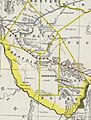
Map of Presidio County, Texas, and the counties of Brewster, Buchel, Foley, and Jeff Davis created from Presidio in 1887: Buchel and Foley were abolished and joined to Brewster in 1897.
See also
 In Spanish: Condado de Presidio para niños
