Jeff Davis County, Texas facts for kids
Quick facts for kids
Jeff Davis County
|
|
|---|---|
|
County
|
|

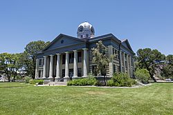
Jeff Davis County Courthouse in Fort Davis
|
|

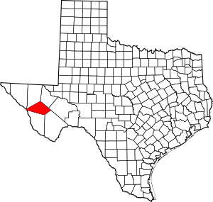
Location within the U.S. state of Texas
|
|
 Texas's location within the U.S. |
|
| Country | |
| State | |
| Founded | 1887 |
| Named for | Jefferson Davis |
| Seat | Fort Davis |
| Largest town | Fort Davis |
| Area | |
| • Total | 2,265 sq mi (5,870 km2) |
| • Land | 2,265 sq mi (5,870 km2) |
| • Water | 0.08 sq mi (0.2 km2) 0% |
| Population
(2020)
|
|
| • Total | 1,996 |
| • Density | 0.8812/sq mi (0.34025/km2) |
| Time zone | UTC−6 (Central) |
| • Summer (DST) | UTC−5 (CDT) |
| Congressional district | 23rd |
Jeff Davis County is a county located in the state of Texas in the United States. In 2020, about 1,996 people lived there. The main town and county seat is Fort Davis. The county is named after Jefferson Davis. He was an important leader in the 1850s and later became the president of the Confederate States.
Jeff Davis County has a very interesting shape. It looks like a five-sided figure (a pentagon). It is the only county in the United States that touches a foreign country (Mexico) at just one point. This county is part of the Trans-Pecos region in West Texas.
The county is home to the Davis Mountains, which are famous for growing grapes for wine. It also has the McDonald Observatory, a major place for studying stars. The observatory is owned by the University of Texas at Austin and is located near Fort Davis.
Contents
History
Early Peoples and Conflicts
Long ago, people camped at Phantom Lake Spring in what is now Jeff Davis County. They might have used the springs to water their crops. Ancient pictures drawn by Native Americans can still be seen in Limpia Canyon.
As more settlers moved into the area, there were often conflicts with Native American groups. They fought over land and resources for many years. In 1861, Mescalero Apache warriors attacked Fort Davis. They took animals and killed some people. Soldiers chased them, but the Apache leader, Nicolas, surprised the soldiers and defeated them.
Later, in 1868, Mexican volunteers and buffalo soldiers from Fort Davis attacked a Mescalero village. They wanted to get back people who had been captured and animals that were stolen. In 1880, soldiers fought against Mescalero Apache led by Chief Victorio. Victorio eventually went to Mexico, where he was killed by Mexican soldiers. The last Native American attack in the area happened in 1881.
Fort Davis and County Beginnings

In 1849, explorers like William H. C. Whiting looked for new routes from San Antonio to El Paso. Soon after, Fort Bliss was set up in El Paso. The famous Texas Ranger Big Foot Wallace helped protect mail coaches through the mountains.
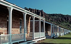
Fort Davis was built in 1854. It was used by the U.S. Army to protect settlers and control Native American groups. During the American Civil War, the fort was taken over by the Confederacy. But they left it in 1862 after a battle in New Mexico. U.S. troops returned to the fort in 1867.
County Formation and Growth
The state of Texas officially created Jeff Davis County on March 15, 1887. Fort Davis was chosen as the county seat. Ranchers started raising cattle in the county in the 1880s. Towns like Valentine and Chispa grew as places where ranchers could get supplies. These towns later became stops for trains as railroads were built.
Fort Davis has always been the largest town in the county. In the 1930s, Davis Mountains State Park opened to the public. This park was improved during the Great Depression, a time when many people needed jobs.
In 1961, Fort Davis National Historic Site was created to protect the old fort. The Chihuahuan Desert Research Institute, which studies the desert, opened its arboretum (a type of tree garden) in 1974.
Geography
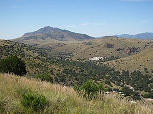
Jeff Davis County covers about 2,265 square miles. Almost all of this area is land. The county is home to the Davis Mountains, which are the tallest mountains completely within Texas.
Protected Natural Areas

Jeff Davis County has several parks and natural areas. These are managed by state and federal park services, as well as groups like the Chihuahuan Desert Research Institute and The Nature Conservancy of Texas. The Nature Conservancy also helps protect many thousands of acres of private land around its preserve.
| Park or preserve | Managed by | Area | Year started |
|---|---|---|---|
| Chihuahuan Desert Nature Center and Botanical Gardens | Chihuahuan Desert Research Institute | 507 acres | 1978 |
| Davis Mountains State Park | Texas Parks and Wildlife Department | 2,709 acres | 1933 |
| Davis Mountains Preserve | The Nature Conservancy of Texas | 33,075 acres | 1997 |
| Fort Davis National Historic Site | National Park Service | 523 acres | 1961 |
Main Roads
 Interstate 10
 U.S. Highway 90
 State Highway 17
 State Highway 118
 State Highway 166
Neighboring Counties and Cities
- Reeves County (north)
- Pecos County (north)
- Brewster County (southeast)
- Presidio County (south)
- Guadalupe, Chihuahua, Mexico (west)
- Hudspeth County (northwest)
- Culberson County (north)
Climate
Jeff Davis County mostly has a semiarid steppe climate. This means it's usually dry, like a desert, but gets a bit more rain than a true desert. Temperatures are generally milder at higher elevations, and more rain falls from May to October. Snowfall is also more common in the higher parts of the county.
Population Information
As of 2021, Jeff Davis County has an older population, with a median age of 60 years. This makes it one of the few counties in the United States with such a high median age.
| Historical population | |||
|---|---|---|---|
| Census | Pop. | %± | |
| 1890 | 1,394 | — | |
| 1900 | 1,150 | −17.5% | |
| 1910 | 1,678 | 45.9% | |
| 1920 | 1,445 | −13.9% | |
| 1930 | 1,800 | 24.6% | |
| 1940 | 2,375 | 31.9% | |
| 1950 | 2,090 | −12.0% | |
| 1960 | 1,582 | −24.3% | |
| 1970 | 1,527 | −3.5% | |
| 1980 | 1,647 | 7.9% | |
| 1990 | 1,946 | 18.2% | |
| 2000 | 2,207 | 13.4% | |
| 2010 | 2,342 | 6.1% | |
| 2020 | 1,996 | −14.8% | |
| U.S. Decennial Census 1850–2010 2010–2014 2020 |
|||
Here's a look at the different groups of people living in Jeff Davis County:
| Race / Ethnicity (NH = Non-Hispanic) | Pop 2000 | Pop 2010 | Pop 2020 | % 2000 | % 2010 | % 2020 |
|---|---|---|---|---|---|---|
| White alone (NH) | 1,376 | 1,490 | 1,282 | 62.35% | 63.62% | 64.23% |
| Black or African American alone (NH) | 16 | 10 | 0 | 0.72% | 0.43% | 0.00% |
| Native American or Alaska Native alone (NH) | 6 | 8 | 6 | 0.27% | 0.34% | 0.30% |
| Asian alone (NH) | 2 | 7 | 14 | 0.09% | 0.30% | 0.70% |
| Pacific Islander alone (NH) | 0 | 1 | 0 | 0.00% | 0.04% | 0.00% |
| Other race alone (NH) | 1 | 1 | 15 | 0.05% | 0.04% | 0.75% |
| Mixed race or Multiracial (NH) | 23 | 35 | 66 | 1.04% | 1.49% | 3.31% |
| Hispanic or Latino (any race) | 783 | 790 | 613 | 35.48% | 33.73% | 30.71% |
| Total | 2,207 | 2,342 | 1,996 | 100.00% | 100.00% | 100.00% |
In 2020, the county had 1,996 people. Most people were White (64.23%), and about 30.71% were Hispanic or Latino.
Education
Students in western Jeff Davis County go to schools in the Valentine Independent School District. Those in the central and eastern parts of the county attend schools in the Fort Davis Independent School District.
All of Jeff Davis County is also part of the area served by Odessa College, which offers higher education.
Communities
- Valentine
- Fort Davis (county seat)
See also
 In Spanish: Condado de Jeff Davis (Texas) para niños
 | Victor J. Glover |
 | Yvonne Cagle |
 | Jeanette Epps |
 | Bernard A. Harris Jr. |


