
Davis Mountains facts for kids
Quick facts for kids Davis MountainsLimpia Mountains |
|
|---|---|

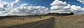
View from Remington Ridge
|
|
| Highest point | |
| Peak | Baldy Peak atop Mount Livermore |
| Elevation | 8,383 ft (2,555 m) |
| Geography | |

Davis Mountains
Limpia Mountains Location in Texas
|
|
| Country | United States |
| State | Texas |
| Geology | |
| Age of rock | Paleogene |
| Type of rock | Igneous |
The Davis Mountains, also called the Limpia Mountains, are a group of mountains in West Texas. They are found near Fort Davis, a town named after them. The fort itself was named for Jefferson Davis, who was once a very important government official in the United States. Later, he became the leader of the Confederate States during the American Civil War.
These mountains are a great place for outdoor adventures like camping and hiking. The area includes the Fort Davis National Historic Site and Davis Mountains State Park. Both the historic fort and the beautiful natural park attract many visitors to Texas.
Most of the land in the Davis Mountains is privately owned by ranchers. However, a group called Nature Conservancy helps protect over 100,000 acres (about 40,000 hectares) of this land. They either own it or have special agreements to keep it natural.

Contents
What are the Davis Mountains Like?
The Davis Mountains are not one long mountain range. Instead, they are a mix of separate peaks and ridges. These are separated by flatter areas. The mountains cover a rough square shape, about 50 kilometers (31 miles) on each side.
How Were the Mountains Formed?
These mountains were formed by volcanoes. About 35 million years ago, there were many volcanic eruptions in the Trans-Pecos Volcanic Field. The rocks you see today are from those ancient lava flows. The tallest peak in the Davis Mountains is Mount Livermore. It stands at 2,555 meters (8,383 feet) high. This makes it the fifth-highest peak in all of Texas!
Plants and Trees of the Davis Mountains
The Davis Mountains are a special place known as a sky island. Imagine an island of green forest in the middle of a dry desert. That's what a sky island is! The town of Fort Davis is at the base of the mountains, about 1,500 meters (4,921 feet) high. From there, the mountains rise to 2,555 meters (8,383 feet).
Why is it a Sky Island?
As you go higher up the mountain, the air gets cooler. It also rains more. This allows different kinds of plants and trees to grow. These plants need more water than desert plants. So, the higher parts of the mountains become a green "island" of forest.

Different Plant Zones
The most common plants in the Davis Mountains are mountain grasses. You'll also see scattered bushes and trees. On the sunny southern slopes, there are fewer plants. This is because these areas get more sun, making them warmer and drier. The northern slopes have more plants because they are cooler and hold more moisture.
There are four main types of woodlands and forests:
- Juniper and Oak Woodlands: Below 1,900 meters (6,234 feet), you'll find alligator juniper trees mixed with different kinds of oaks and pinyon pine.
- Pinyon Pine Woodlands: On steep slopes between 1,750 and 2,400 meters (5,741 to 7,874 feet), pinyon pine is the most common tree.
- Gray Oak Woodlands: Also on steep slopes from 1,900 to 2,400 meters (6,234 to 7,874 feet), you'll find woodlands where gray oak is the main tree. These areas are a bit wetter than the pinyon woodlands.
- Moist Forests: The richest forests are found in stream valleys and other well-watered spots. These are between 1,770 and 2,330 meters (5,807 to 7,644 feet). Here, you'll see ponderosa pine and southwestern white pine. There are even two small groups of quaking aspen trees near the top of Mount Livermore, around 2,300 meters (7,546 feet). Aspens are usually found in the much colder Rocky Mountains. These moist forests are like a leftover from past Ice Ages, when West Texas was cooler and wetter.
Animals of the Davis Mountains
The Davis Mountains are home to many different animals. Over 277 types of birds have been seen at Davis Mountains State Park! Many birds here are usually found in mountains further north or in Mexico. This includes 10 different kinds of hummingbirds.
Large Mammals You Might See
You might spot large mammals like whitetail deer, mule deer, elk, black bear, cougar, pronghorn, and peccary (a type of wild pig). There are also some animals that were brought here, like aoudad (a type of wild sheep) and wild hogs.
Long ago, in 1890, the only grizzly bear ever recorded in Texas was found in the Davis Mountains. Some private ranches in the area also offer hunting opportunities.
Weather in the Davis Mountains
Most of the Davis Mountains have a semiarid steppe climate. This means it's generally dry, like a grassland. However, the very highest parts of the mountains can have a cooler, wetter climate, similar to a humid subtropical area with warm summers.
| Climate data for Mount Locke, Texas, 1981-2010 normals, extremes 1935-present | |||||||||||||
|---|---|---|---|---|---|---|---|---|---|---|---|---|---|
| Month | Jan | Feb | Mar | Apr | May | Jun | Jul | Aug | Sep | Oct | Nov | Dec | Year |
| Record high °F (°C) | 80 (27) |
81 (27) |
88 (31) |
94 (34) |
96 (36) |
104 (40) |
104 (40) |
104 (40) |
96 (36) |
94 (34) |
82 (28) |
80 (27) |
104 (40) |
| Mean daily maximum °F (°C) | 54.7 (12.6) |
58.2 (14.6) |
64.7 (18.2) |
72.1 (22.3) |
80.3 (26.8) |
85.5 (29.7) |
84.0 (28.9) |
82.3 (27.9) |
78.3 (25.7) |
72.4 (22.4) |
62.7 (17.1) |
55.0 (12.8) |
70.9 (21.6) |
| Daily mean °F (°C) | 43.8 (6.6) |
46.7 (8.2) |
51.9 (11.1) |
59.0 (15.0) |
67.1 (19.5) |
72.4 (22.4) |
72.0 (22.2) |
70.9 (21.6) |
66.9 (19.4) |
60.6 (15.9) |
51.4 (10.8) |
44.4 (6.9) |
58.9 (15.0) |
| Mean daily minimum °F (°C) | 32.9 (0.5) |
35.2 (1.8) |
39.2 (4.0) |
45.8 (7.7) |
53.8 (12.1) |
59.4 (15.2) |
60.0 (15.6) |
59.5 (15.3) |
55.5 (13.1) |
48.9 (9.4) |
40.0 (4.4) |
33.7 (0.9) |
47.0 (8.3) |
| Record low °F (°C) | −10 (−23) |
−6 (−21) |
4 (−16) |
11 (−12) |
24 (−4) |
34 (1) |
40 (4) |
40 (4) |
29 (−2) |
14 (−10) |
8 (−13) |
−2 (−19) |
−10 (−23) |
| Average precipitation inches (mm) | 0.53 (13) |
0.55 (14) |
0.43 (11) |
0.81 (21) |
1.71 (43) |
2.77 (70) |
3.79 (96) |
3.77 (96) |
2.81 (71) |
1.70 (43) |
0.57 (14) |
0.63 (16) |
20.07 (508) |
| Average snowfall inches (cm) | 0.9 (2.3) |
0.8 (2.0) |
0.1 (0.25) |
0.0 (0.0) |
0.0 (0.0) |
0.0 (0.0) |
0.0 (0.0) |
0.0 (0.0) |
0.0 (0.0) |
0.1 (0.25) |
0.3 (0.76) |
1.9 (4.8) |
4.1 (10.36) |
| Average precipitation days (≥ 0.01 in) | 3.6 | 3.3 | 3.0 | 2.9 | 6.3 | 9.6 | 12.2 | 12.3 | 9.3 | 6.5 | 3.0 | 3.3 | 75.3 |
| Average snowy days (≥ 0.1 in) | 0.8 | 0.5 | 0.1 | 0.0 | 0.0 | 0.0 | 0.0 | 0.0 | 0.0 | 0.0 | 0.2 | 1.3 | 2.9 |
| Source: NOAA | |||||||||||||

Protecting the Davis Mountains
Most of the Davis Mountains are owned by private individuals. However, since 1996, a group called The Nature Conservancy has been working to protect this special area. They have bought 33,000 acres (about 130 square kilometers) of land. They also have agreements with ranchers to protect another 70,000 acres (280 square kilometers) of private land. The Davis Mountain Preserve is open to the public at certain times.

Things to See and Do
The McDonald Observatory is a famous place in the Davis Mountains. You can get there by taking Spur 78 from State Highway 118. Spur 78 is the highest state-maintained road in Texas! It reaches 6,791 feet (2,070 meters) near the top of Mount Locke. This is where the observatory's older telescopes are located. Another road, Spur 77, branches off Spur 78. It leads to the newer research equipment on Mount Fowlkes.
Images for kids
-
Rolling hills in the Davis Mountains
