Menard County, Texas facts for kids
Quick facts for kids
Menard County
|
|
|---|---|

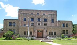
The Menard County Courthouse in Menard
|
|

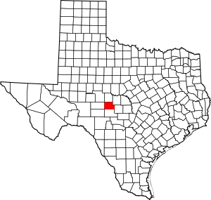
Location within the U.S. state of Texas
|
|
 Texas's location within the U.S. |
|
| Country | |
| State | |
| Founded | 1871 |
| Named for | Michel Branamour Menard |
| Seat | Menard |
| Largest city | Menard |
| Area | |
| • Total | 902 sq mi (2,340 km2) |
| • Land | 902 sq mi (2,340 km2) |
| • Water | 0.2 sq mi (0.5 km2) 0.03% |
| Population
(2020)
|
|
| • Total | 1,962 |
| • Density | 2.1752/sq mi (0.8398/km2) |
| Time zone | UTC−6 (Central) |
| • Summer (DST) | UTC−5 (CDT) |
| Congressional district | 11th |

Menard County is a county in the state of Texas, USA. It is located on the Edwards Plateau, a high flat area of land. In 2020, about 1,962 people lived there. The main town and county seat is Menard. The county was formed in 1858 and officially started in 1871. It is named after Michel Branamour Menard, who founded the city of Galveston, Texas.
Contents
History of Menard County
Early Native American Life
Around 8,000 years ago, the first Native Americans lived in this area. Later, groups like the Comanche and Lipan Apache called it home. In 1757, a Spanish priest named Father Alonso Giraldo de Terreros started a fort called Presidio San Luis de las Amarillas. This fort helped protect the Santa Cruz de San Sabá Mission, which was for the Apache people.
The Legend of the Lost Mine
In the 1830s, two brothers, James Bowie and Rezin P. Bowie, explored the San Saba valley. They were looking for a silver mine that the Spanish believed was hidden there. They never found it, but the story of the Lost Bowie Mine (also known as the Lost San Saba Mine) has kept treasure hunters interested for over 150 years!
Forming the County
To protect settlers from Native American attacks, Camp San Saba was built in 1852. In 1858, the state government created Menard County from a larger area called Bexar County. The county was named after Michel Branamour Menard. The town of Menardville, later called Menard, became the county seat.
By 1870, Menard County had 667 people. Many of them were African American soldiers, possibly the Buffalo Soldiers stationed at Fort McKavett. In 1871, the people of Menard County elected their own leaders. Many immigrants from Mexico also moved to the area.
Growth and Development
In 1911, the Fort Worth and Rio Grande Railroad Company built train tracks to Menard County. This helped the county grow. Natural gas was found in 1929, but it wasn't used much at first.
During tough times, the community helped each other. In 1931, the local Parent-Teacher Association (PTA) gave free lunches to children who needed them. In 1934, the Texas Relief Cannery helped process food. The Drought Relief Program bought cattle and sheep from ranchers to help them during dry periods.
More gas was found in 1941. A small oilfield was discovered near Fort McKavett in 1946, but it was later closed. By the 1960s, oil and gas production was strong. Even in the 1980s, about 20 oilfields were still active, producing a lot of oil each year.
Geography of Menard County
Menard County covers about 902 square miles. Almost all of this area is land, with only a tiny bit of water.
Main Roads
Neighboring Counties
Menard County shares borders with these other counties:
- Concho County (north)
- McCulloch County (northeast)
- Mason County (east)
- Kimble County (south)
- Schleicher County (west)
- Sutton County (southwest)
- Tom Green County (northwest)
People of Menard County
| Historical population | |||
|---|---|---|---|
| Census | Pop. | %± | |
| 1870 | 667 | — | |
| 1880 | 1,239 | 85.8% | |
| 1890 | 1,215 | −1.9% | |
| 1900 | 2,011 | 65.5% | |
| 1910 | 2,707 | 34.6% | |
| 1920 | 3,162 | 16.8% | |
| 1930 | 4,447 | 40.6% | |
| 1940 | 4,521 | 1.7% | |
| 1950 | 4,175 | −7.7% | |
| 1960 | 2,964 | −29.0% | |
| 1970 | 2,646 | −10.7% | |
| 1980 | 2,346 | −11.3% | |
| 1990 | 2,252 | −4.0% | |
| 2000 | 2,360 | 4.8% | |
| 2010 | 2,242 | −5.0% | |
| 2020 | 1,962 | −12.5% | |
| U.S. Decennial Census 1850–2010 2010 2020 |
|||
The population of Menard County has changed over the years. You can see how many people lived there in different census years in the table above.
| Race / Ethnicity | Pop 2010 | Pop 2020 | % 2010 | % 2020 |
|---|---|---|---|---|
| White alone (NH) | 1,425 | 1,231 | 63.56% | 62.74% |
| Black or African American alone (NH) | 11 | 12 | 0.49% | 0.61% |
| Native American or Alaska Native alone (NH) | 6 | 7 | 0.27% | 0.36% |
| Asian alone (NH) | 3 | 5 | 0.13% | 0.25% |
| Pacific Islander alone (NH) | 0 | 3 | 0.00% | 0.15% |
| Some Other Race alone (NH) | 1 | 8 | 0.04% | 0.41% |
| Mixed Race/Multi-Racial (NH) | 6 | 34 | 0.27% | 1.73% |
| Hispanic or Latino (any race) | 790 | 662 | 35.24% | 33.74% |
| Total | 2,242 | 1,962 | 100.00% | 100.00% |
Note: the US Census treats Hispanic/Latino as an ethnic category. This table excludes Latinos from the racial categories and assigns them to a separate category. Hispanics/Latinos can be of any race.
In 2000, there were 2,360 people living in Menard County. About 28.5% of households had children under 18. Many households were married couples. The average age of people in the county was 44 years old. About 24.2% of the population was under 18.
Communities in Menard County
City
- Menard (This is the main town and where the county government is located.)
Small Towns and Areas
- Callan
- Erna
- Hext
- Saline
Old Towns (Ghost Towns)
- Fort McKavett
- Sunnyside
Menard County in Movies
The 1968 movie Journey to Shiloh talks about a group called the "Concho County Comanches." Menard County is also mentioned in this film.
See also
 In Spanish: Condado de Menard (Texas) para niños
 | Bayard Rustin |
 | Jeannette Carter |
 | Jeremiah A. Brown |

