Kerr County, Texas facts for kids
Quick facts for kids
Kerr County
|
|
|---|---|

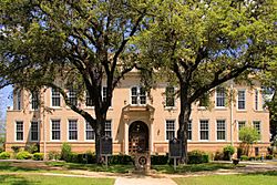
Kerr County Courthouse, southside view
|
|

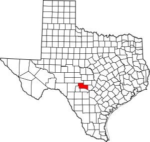
Location within the U.S. state of Texas
|
|
 Texas's location within the U.S. |
|
| Country | |
| State | |
| Founded | 1856 |
| Named for | James Kerr |
| Seat | Kerrville |
| Largest city | Kerrville |
| Area | |
| • Total | 1,107 sq mi (2,870 km2) |
| • Land | 1,103 sq mi (2,860 km2) |
| • Water | 4.0 sq mi (10 km2) 0.4% |
| Population
(2020)
|
|
| • Total | 52,598 |
| • Density | 47.514/sq mi (18.345/km2) |
| Time zone | UTC−6 (Central) |
| • Summer (DST) | UTC−5 (CDT) |
| Congressional district | 21st |
Kerr County is a county located in the state of Texas, USA. It sits on the Edwards Plateau, a high, flat area of land. As of the 2020 census, about 52,598 people lived here. The main city and county seat is Kerrville. The county was named after James Kerr, a politician from the Republic of Texas. The Kerrville area, including all of Kerr County, is considered a "micropolitan statistical area," meaning it's a small city area with close ties to nearby communities.
Contents
History of Kerr County
Around 8000 BC, the first Native Americans arrived in this area. Many different groups lived here over thousands of years. When Europeans first explored the region, they met tribes like the Kiowa, Comanche, and Lipan Apache.
In 1842, a large piece of land called the Fisher–Miller Land Grant was set aside. It was meant to help 600 families and single men from Germany, the Netherlands, Switzerland, Denmark, Sweden, and Norway settle in Texas.
In 1845, a group called the Adelsverein bought some land near the Comal Springs. Thousands of German immigrants arrived at the port of Indianola. They faced very tough conditions with little food or shelter. Many became sick or starved. In 1846, Joshua Brown became the first permanent settler in the area.
In 1854, German Texans met in San Antonio. They discussed important ideas like equal pay for equal work and direct election of the U.S. President. They also believed that slavery was wrong and that schools should be free and not controlled by religion. The next year, a U.S. Army post called Camp Verde was built.
Kerr County was officially created in 1856. Joshua Brown gave the land for the main town, and he named it Kerrville after his friend James Kerr. Kerrville became the county seat. An interesting project, the United States Camel Corps, was based at Camp Verde. This idea came from Jefferson Davis, who was the Secretary of War at the time. They tried using camels for transportation in the desert!
Center Point was founded in 1859.
In 1860, the county had 634 people, including 49 enslaved people. During the American Civil War, Kerr County was divided. Many German residents were against leaving the Union. In 1861, the county voted to secede, but it was a close vote. Some people formed a secret group called the Union League to support President Lincoln. They tried to protect their families and the frontier from Native American attacks and Confederate forces.
Some people who did not want to fight in the war, called conscientious objectors, tried to escape to Mexico. In an event known as the Nueces massacre, many of these objectors lost their lives. A monument called the Treue der Union Monument ("Loyalty to the Union") in Comfort honors these Texans. It is special because it is one of the few places outside national cemeteries on Confederate land where the U.S. flag can fly at half-mast forever.
In 1880, Charles Armand Schreiner started the Y O Ranch. He had opened a store in the area years before.
The San Antonio and Aransas Pass Railway came through Kerrville in 1887. Later, in 1919, the American Legion helped create what is now the Veterans Affairs Medical Center in Kerrville.
The Schreiner Institute was founded in Kerrville between 1917 and 1923. In 1926, a Christian girls' camp called Camp Waldemar was started in Hunt.
Mooney Aircraft began building planes in Kerrville in 1929. By the 1930s, Kerrville was known as the "Mohair Capital of the World" because of its important role in producing mohair, a fabric from angora goats.
The Sid Peterson Memorial Hospital was finished in 1949. The Kerrville State Hospital opened in 1951.
Geography
Kerr County covers a total area of about 1,107 square miles. Most of this (1,103 square miles) is land, and only a small part (4.0 square miles) is water.
Major highways
 Interstate 10
 U.S. Highway 83
 U.S. Highway 87
 State Highway 16
 State Highway 27
 State Highway 39
 State Highway 41
 State Highway 173
Adjacent counties
- Kimble County (north)
- Gillespie County (northeast)
- Kendall County (east)
- Bandera County (south)
- Real County (southwest)
- Edwards County (west)
Population Information
| Historical population | |||
|---|---|---|---|
| Census | Pop. | %± | |
| 1860 | 634 | — | |
| 1870 | 1,042 | 64.4% | |
| 1880 | 2,168 | 108.1% | |
| 1890 | 4,462 | 105.8% | |
| 1900 | 4,980 | 11.6% | |
| 1910 | 5,505 | 10.5% | |
| 1920 | 5,842 | 6.1% | |
| 1930 | 10,151 | 73.8% | |
| 1940 | 11,650 | 14.8% | |
| 1950 | 14,022 | 20.4% | |
| 1960 | 16,800 | 19.8% | |
| 1970 | 19,454 | 15.8% | |
| 1980 | 28,780 | 47.9% | |
| 1990 | 36,304 | 26.1% | |
| 2000 | 43,653 | 20.2% | |
| 2010 | 49,625 | 13.7% | |
| 2020 | 52,598 | 6.0% | |
| U.S. Decennial Census 1850–2010 2010 2020 |
|||
| Race / Ethnicity (NH = Non-Hispanic) | Pop 2000 | Pop 2010 | Pop 2020 | % 2000 | % 2010 | % 2020 |
|---|---|---|---|---|---|---|
| White alone (NH) | 33,802 | 35,851 | 35,791 | 77.43% | 72.24% | 68.05% |
| Black or African American alone (NH) | 738 | 739 | 690 | 1.69% | 1.49% | 1.31% |
| Native American or Alaska Native alone (NH) | 154 | 207 | 156 | 0.35% | 0.42% | 0.30% |
| Asian alone (NH) | 212 | 361 | 576 | 0.49% | 0.73% | 1.10% |
| Pacific Islander alone (NH) | 16 | 19 | 39 | 0.04% | 0.04% | 0.07% |
| Other Race alone (NH) | 12 | 38 | 187 | 0.03% | 0.08% | 0.36% |
| Mixed Race or Multiracial (NH) | 366 | 515 | 1,561 | 0.84% | 1.04% | 2.97% |
| Hispanic or Latino (any race) | 8,353 | 11,895 | 13,598 | 19.13% | 23.97% | 25.85% |
| Total | 43,653 | 49,625 | 52,598 | 100.00% | 100.00% | 100.00% |
In 2000, there were 43,653 people living in Kerr County. This included 17,813 households and 12,308 families. The population density was about 40 people per square mile.
About 25.5% of households had children under 18. Most households (56.8%) were married couples living together. About 27.5% of households were individuals living alone. The average household had 2.35 people.
The population was spread out by age. About 22.7% were under 18, and 24.9% were 65 or older. The average age was 44 years old. For every 100 females, there were about 92 males.
Communities
Cities
Unincorporated communities
Education
Several school districts serve the students of Kerr County:
- Center Point Independent School District
- Comfort Independent School District
- Divide Independent School District
- Harper Independent School District
- Hunt Independent School District
- Ingram Independent School District
- Kerrville Independent School District
- Medina Independent School District
All of Kerr County is also part of the Alamo Community College District, which offers college courses and programs.
See also
 In Spanish: Condado de Kerr para niños
 | Jewel Prestage |
 | Ella Baker |
 | Fannie Lou Hamer |

