Brackettville, Texas facts for kids
Quick facts for kids
Brackettville, Texas
|
|
|---|---|

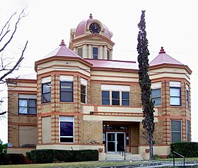
Kinney County courthouse
|
|
| Country | United States |
| State | Texas |
| County | Kinney |
| Area | |
| • Total | 3.17 sq mi (8.21 km2) |
| • Land | 3.17 sq mi (8.21 km2) |
| • Water | 0.00 sq mi (0.00 km2) |
| Elevation | 1,106 ft (337 m) |
| Population
(2020)
|
|
| • Total | 1,341 |
| • Density | 423.16/sq mi (163.38/km2) |
| Time zone | UTC-6 (Central (CST)) |
| • Summer (DST) | UTC-5 (CDT) |
| ZIP code |
78832
|
| Area code(s) | 830 |
| FIPS code | 48-09868 |
| GNIS feature ID | 1352804 |
Brackettville is a small city in Kinney County, Texas, United States. It is the main town in Kinney County. In 2020, about 1,341 people lived there. This was a bit less than the 1,688 people who lived there in 2010.
Contents
History of Brackettville
Brackettville was started in 1852. It was first called "Las Moras," named after a nearby natural spring and the creek it feeds. The town was an important stop for travelers on the old road between San Antonio and El Paso. It also served as a supply center for the U.S. Army's Fort Clark, which was built in the same year.
Later, the town was renamed "Brackett" after Oscar B. Brackett. He owned the first general store in the area. In 1873, when the town got its own post office, "ville" was added to the name. This was to make sure people didn't confuse it with another town.
Fort Clark and the Buffalo Soldiers
The town grew a lot during the 1800s because of Fort Clark. The fort became bigger during the Indian Wars. For many years, Fort Clark was home to the famous Buffalo Soldiers. These were African American soldiers who served in the U.S. Army.
Many Black Seminoles also lived in Brackettville. These were African Americans who had escaped slavery and lived with the Seminole Native Americans. They had moved to northern Mexico to be free before the 2nd Seminole War. They spoke a special language called Afro-Seminole Creole, which some people in Brackettville still speak today.
After the Indian Wars ended, the Buffalo Soldiers moved from Fort Clark. The fort then became a training base for cavalry (soldiers who fight on horseback). Almost every cavalry unit in the U.S. Army trained at Fort Clark at some point. The Seminole Negro Indian Scouts, a special unit, were officially ended in 1914.
Fort Clark in World War II and Beyond
During World War II in 1943, the U.S. Army's Second Cavalry Division was based at Fort Clark. This was the last army unit that used horses. By 1944, even this unit started using machines instead of horses. Fort Clark, which was known for its horse cavalry, was set to close. Before it closed, it was used as a camp for German prisoner-of-wars.
Fort Clark officially closed in 1946. After that, it was used for different things. In 1971, it became a resort and retirement center. The historic parts of the fort are now listed on the National Register of Historic Places. Even though the resort is there, it doesn't bring as much money to Brackettville as the fort used to. Because of this, Brackettville's population has become smaller since its busiest times during the war.
Fun Facts and Movies
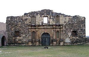
North of Brackettville, you can find a place called Alamo Village. This was built in 1959 to be the movie set for John Wayne's film The Alamo. It's a replica of the famous Alamo fort.
Other movies and TV shows have also been filmed in and around Brackettville. These include the comedy Viva Max! (1969), the miniseries James A. Michener's Texas (1994), and westerns like Two Rode Together (1961) and Lonesome Dove (1989).
As of 2009, Alamo Village is closed to the public for tours. However, it is still used for filming movies and for special events like weddings.
Where is Brackettville?
Brackettville is located in the middle of Kinney County. It is right next to Fort Clark Springs, which is a smaller community built on the old Fort Clark site.
The city covers about 8.2 square kilometers (3.17 square miles) of land. A small part of this area, about 0.9 square kilometers, is water.
Getting Around
U.S. Route 90 runs along the south side of Brackettville. If you go east on this road, you'll reach Uvalde in about 39 miles. If you go west, you'll get to Del Rio in about 30 miles. Texas State Highway 131 goes south from Brackettville to Eagle Pass, which is about 45 miles away.
The closest airport with flights is Del Rio International Airport. It's about 32 miles from Brackettville.
Brackettville's Weather
Brackettville has a humid subtropical climate. This means it has hot and humid summers. The winters are usually mild or cool. The amount of rain can change, but it's generally moderate throughout the year.
Population Changes
| Historical population | |||
|---|---|---|---|
| Census | Pop. | %± | |
| 1880 | 1,126 | — | |
| 1890 | 1,649 | 46.4% | |
| 1930 | 1,822 | — | |
| 1940 | 2,653 | 45.6% | |
| 1950 | 1,858 | −30.0% | |
| 1960 | 1,662 | −10.5% | |
| 1970 | 1,539 | −7.4% | |
| 1980 | 1,676 | 8.9% | |
| 1990 | 1,740 | 3.8% | |
| 2000 | 1,876 | 7.8% | |
| 2010 | 1,688 | −10.0% | |
| 2020 | 1,341 | −20.6% | |
| U.S. Decennial Census | |||
In 2020, the 2020 United States census counted 1,341 people living in Brackettville. There were 568 households and 346 families in the city. Most of the people living in Brackettville were of Hispanic or Latino background (about 73%). A smaller number were White (about 22%) or Black/African American (about 1.8%).
Schools in Brackettville
Students in Brackettville go to schools that are part of the Brackett Independent School District.
See also
 In Spanish: Brackettville para niños
 | Selma Burke |
 | Pauline Powell Burns |
 | Frederick J. Brown |
 | Robert Blackburn |


