
Eagle Pass, Texas facts for kids
Quick facts for kids
Eagle Pass, Texas
|
|
|---|---|
 |
|
| Nicknames:
El Aguilón
El Paso del Águila Illegal Pass |
|

Location of Eagle Pass, Texas
|
|
| Country | United States |
| State | Texas |
| County | Maverick |
| Government | |
| • Type | Council-Manager |
| Area | |
| • Total | 9.49 sq mi (24.58 km2) |
| • Land | 9.42 sq mi (24.40 km2) |
| • Water | 0.07 sq mi (0.18 km2) |
| Elevation | 732 ft (223 m) |
| Population | |
| • Total | 28,130 |
| • Density | 3,150.83/sq mi (1,216.59/km2) |
| Time zone | UTC-6 (Central (CST)) |
| • Summer (DST) | UTC-5 (CDT) |
| ZIP codes |
78852-78853
|
| Area code(s) | 830 |
| FIPS code | 48-21892 |
| GNIS feature ID | 1356538 |
Eagle Pass is a city in Texas, located right on the border with Mexico. It is the main city in Maverick County. In 2020, about 28,130 people lived there.
Eagle Pass is special because it sits across the Rio Grande river from Piedras Negras, Coahuila, Mexico. This makes it an important place for people and goods to cross between the two countries.
Contents
Discovering Eagle Pass: A Look at Its Past
Eagle Pass was the first American settlement along the Rio Grande river. It started as a temporary army camp called Camp Eagle Pass. Soldiers were sent there during the Mexican–American War to stop illegal trade with Mexico.
The city got its name because the hills around the Rio Grande looked like an eagle's wings spread out.
How Eagle Pass Began
General William Leslie Cazneau helped start the town of Eagle Pass in the 1840s. In 1850, a man named Rick Pawless opened a trading post there.
Later, in 1871, Maverick County was officially created, and Eagle Pass became its main city. Over time, schools and churches were built. Businesses like stores and ranching grew, and a railway was added.
A Powerful Storm in 2007
On April 24, 2007, a strong tornado hit the area outside Eagle Pass. It caused a lot of damage and sadly, some people lost their lives. The community was greatly affected for over a week.
A school was completely destroyed, but thankfully, everyone had left before it happened. The school has since been rebuilt, and the community has recovered.
Border Changes and Local Issues
In 2008, the US government took legal action against the City of Eagle Pass. This was to build a fence along the United States-Mexico border.
There have been some challenges with local government officials in the past. These issues involved problems with money and contracts. Many people worked to fix these problems and make things better for the community.
More recently, in January 2024, the Texas Governor Greg Abbott declared an emergency. This led to the Texas National Guard and Texas Rangers taking control of Shelby Park. This park is located along the Rio Grande, which is the border with Mexico. This action blocked the United States Border Patrol from patrolling the area. This situation, known as the Standoff at Eagle Pass, is still ongoing and involves different groups managing the border.
Where is Eagle Pass?
Eagle Pass is located at 28°42′38″N 100°29′22″W / 28.71056°N 100.48944°W.
The city covers about 7.4 square miles (19.2 square kilometers) of land. Only a very small part of it is covered by water.
Getting Around Eagle Pass
Major roads that serve Eagle Pass include U.S. Routes 57 and 277. There is also a local road called Farm-to-Market Road 481.
For air travel, Eagle Pass has the Maverick County Memorial International Airport. This airport is for general aviation, like private planes. If you need a commercial flight, the closest airport is about 50 miles away in Del Rio.
Weather in Eagle Pass
Eagle Pass has a hot semi-arid climate. This means it's usually hot and dry. The hottest month is typically August. The highest temperature ever recorded was 115°F (46°C) in 1916 and 1944.
January is usually the coolest month. The lowest temperature ever recorded was 10°F (-12°C) in 1962. Most of the rain falls from spring through fall, with drier winters.
| Climate data for Eagle Pass, Texas, 1991–2020 normals, extremes 1897–2018 | |||||||||||||
|---|---|---|---|---|---|---|---|---|---|---|---|---|---|
| Month | Jan | Feb | Mar | Apr | May | Jun | Jul | Aug | Sep | Oct | Nov | Dec | Year |
| Record high °F (°C) | 96 (36) |
101 (38) |
106 (41) |
108 (42) |
114 (46) |
115 (46) |
115 (46) |
112 (44) |
111 (44) |
106 (41) |
100 (38) |
94 (34) |
115 (46) |
| Mean maximum °F (°C) | 81.7 (27.6) |
86.7 (30.4) |
92.5 (33.6) |
99.1 (37.3) |
101.3 (38.5) |
104.2 (40.1) |
104.2 (40.1) |
105.0 (40.6) |
101.0 (38.3) |
95.7 (35.4) |
88.4 (31.3) |
80.8 (27.1) |
107.4 (41.9) |
| Mean daily maximum °F (°C) | 64.5 (18.1) |
70.0 (21.1) |
77.6 (25.3) |
84.4 (29.1) |
90.3 (32.4) |
96.0 (35.6) |
97.5 (36.4) |
98.6 (37.0) |
91.8 (33.2) |
83.4 (28.6) |
72.4 (22.4) |
64.8 (18.2) |
82.6 (28.1) |
| Daily mean °F (°C) | 52.1 (11.2) |
56.7 (13.7) |
64.5 (18.1) |
71.0 (21.7) |
78.1 (25.6) |
83.9 (28.8) |
85.6 (29.8) |
86.5 (30.3) |
80.4 (26.9) |
71.4 (21.9) |
60.3 (15.7) |
52.3 (11.3) |
70.2 (21.3) |
| Mean daily minimum °F (°C) | 39.7 (4.3) |
43.4 (6.3) |
51.4 (10.8) |
57.7 (14.3) |
65.9 (18.8) |
71.8 (22.1) |
73.8 (23.2) |
74.3 (23.5) |
69.1 (20.6) |
59.3 (15.2) |
48.3 (9.1) |
39.8 (4.3) |
57.9 (14.4) |
| Mean minimum °F (°C) | 28.2 (−2.1) |
30.6 (−0.8) |
36.4 (2.4) |
45.6 (7.6) |
56.8 (13.8) |
65.9 (18.8) |
70.0 (21.1) |
69.6 (20.9) |
57.8 (14.3) |
45.1 (7.3) |
34.9 (1.6) |
27.5 (−2.5) |
24.0 (−4.4) |
| Record low °F (°C) | 10 (−12) |
10 (−12) |
20 (−7) |
32 (0) |
42 (6) |
47 (8) |
62 (17) |
60 (16) |
42 (6) |
27 (−3) |
19 (−7) |
12 (−11) |
10 (−12) |
| Average precipitation inches (mm) | 0.74 (19) |
0.74 (19) |
1.18 (30) |
2.02 (51) |
2.80 (71) |
2.20 (56) |
2.10 (53) |
1.68 (43) |
3.29 (84) |
2.14 (54) |
1.13 (29) |
0.81 (21) |
20.83 (530) |
| Average precipitation days (≥ 0.01 in) | 3.8 | 3.6 | 3.7 | 3.5 | 4.5 | 3.8 | 3.4 | 3.0 | 5.3 | 3.5 | 3.7 | 3.5 | 45.3 |
| Source 1: NOAA | |||||||||||||
| Source 2: National Weather Service (mean maxima/minima 1981–2010) | |||||||||||||
People of Eagle Pass
| Historical population | |||
|---|---|---|---|
| Census | Pop. | %± | |
| 1850 | 383 | — | |
| 1860 | 522 | 36.3% | |
| 1870 | 1,240 | 137.5% | |
| 1880 | 1,627 | 31.2% | |
| 1910 | 3,536 | — | |
| 1920 | 5,765 | 63.0% | |
| 1930 | 5,059 | −12.2% | |
| 1940 | 13,343 | 163.7% | |
| 1950 | 14,211 | 6.5% | |
| 1960 | 12,094 | −14.9% | |
| 1970 | 15,364 | 27.0% | |
| 1980 | 21,407 | 39.3% | |
| 1990 | 20,651 | −3.5% | |
| 2000 | 22,413 | 8.5% | |
| 2010 | 26,248 | 17.1% | |
| 2020 | 28,130 | 7.2% | |
| U.S. Decennial Census 2018 Estimate |
|||
In 2020, Eagle Pass had 28,130 residents. It is part of a larger metropolitan area that includes Piedras Negras in Mexico. This area has over 209,000 people. It's one of six areas where a U.S. city and a Mexican city are connected.
Who Lives in Eagle Pass?
Based on the 2020 United States census:
- There were 28,130 people living in the city.
- Most residents, about 94.79%, are of Hispanic or Latino background.
- The rest of the population includes people of White, Black or African American, Native American, Asian, and Mixed/Multi-Racial backgrounds.
| Race | Number | Percentage |
|---|---|---|
| White (NH) | 1,006 | 3.58% |
| Black or African American (NH) | 117 | 0.42% |
| Native American or Alaska Native (NH) | 61 | 0.22% |
| Asian (NH) | 159 | 0.57% |
| Pacific Islander (NH) | 1 | 0.0% |
| Some Other Race (NH) | 67 | 0.24% |
| Mixed/Multi-Racial (NH) | 55 | 0.2% |
| Hispanic or Latino | 26,664 | 94.79% |
| Total | 28,130 |
What Eagle Pass Does
Eagle Pass has many different businesses, both small and large. The main types of work in the city are:
- Retail: Stores and shops.
- Import/Export: Moving goods across the border.
- Manufacturing: Making products.
Two of the biggest factories in Eagle Pass are Mossberg and MicroStar. In 2014, Maverick Arms also decided to open a factory here. This happened with help from the State of Texas.
The city and Maverick County have rules to help new businesses come to the area. These rules make it easier for companies to open or grow their operations. The city's Economic Development Department handles these programs.
Because Eagle Pass is on the border, many visitors from Mexico come to shop and eat. On a normal weekday, about 6,000 people cross into the U.S. from Mexico. On weekends, this number can go up to 10,000. Many of these visitors stay in Eagle Pass to support local businesses.
Getting Around Eagle Pass
Here are the main highways in the Eagle Pass area:
 U.S. Route 57
 U.S. Route 277
 State Highway 131
Power and Energy
In 2000, a special power station was built in Eagle Pass. This station helps Texas and Mexico share electricity. It allows AEP Texas to buy power from Mexico's Comisión Federal de Electricidad when needed.
News and Media
You can find local news in Eagle Pass through:
- Eagle Pass News Leader
- The News Gram
Famous People from Eagle Pass
Many notable people have connections to Eagle Pass:
- Tres Barrera (born 1994), a baseball catcher for the Washington Nationals.
- Rian James (1899–1953), an author and screenwriter.
- Louis Lane (1923–2016), a conductor for major symphonies.
- Biz Mackey (1897–1965), a famous baseball catcher and manager in the Negro League.
- Robert C. Mathis (1927–2016), a retired four-star general in the U.S. Air Force.
- Guadalupe Garcia McCall, a well-known author and educator.
- Connie Douglas Reeves (1901–2003), a rancher and Hall of Famer.
- Gus Sorola (born 1978), a co-founder of Rooster Teeth, a popular online media company.
Images for kids
-
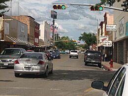
Downtown Eagle Pass
-
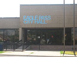
Eagle Pass City Hall at the foot of International Bridge
-
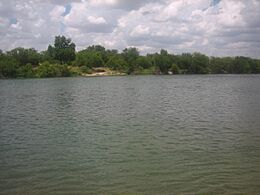
The Rio Grande at Eagle Pass, Texas, with Piedras Negras in the background
-
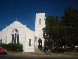
Historic First United Methodist Church on Quarry Street
-
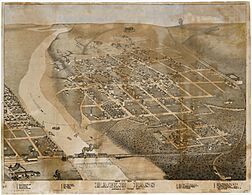
Map of the city 1887
-
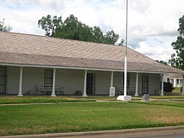
The restored Fort Duncan in Eagle Pass is located near the International Bridge.
-
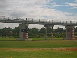
The International Bridge across the Rio Grande in Eagle Pass
-
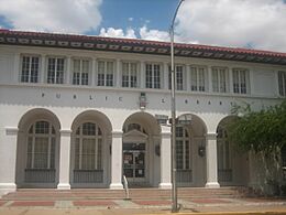
The Eagle Pass public library is located on Main Street east of the Maverick County Courthouse.
-
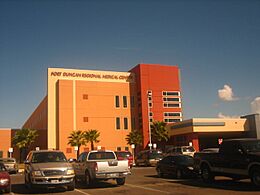
Fort Duncan Medical Center in Eagle Pass is named after the former US Army outpost.
-
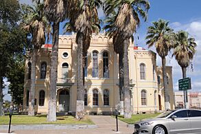
Historic Maverick County Courthouse
-
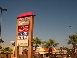
Mall de las Aguilas on Bibb Street in Eagle Pass


See also
 In Spanish: Eagle Pass (Texas) para niños
