Frio County, Texas facts for kids
Quick facts for kids
Frio County
|
|
|---|---|

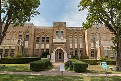
The Frio County Courthouse in Pearsall
|
|

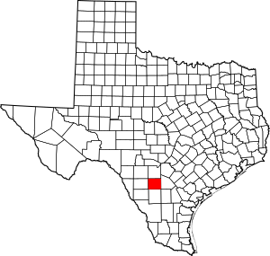
Location within the U.S. state of Texas
|
|
 Texas's location within the U.S. |
|
| Country | |
| State | |
| Founded | 1871 |
| Named for | Frio River |
| Seat | Pearsall |
| Largest city | Pearsall |
| Area | |
| • Total | 1,134 sq mi (2,940 km2) |
| • Land | 1,134 sq mi (2,940 km2) |
| • Water | 0.8 sq mi (2 km2) 0.07%% |
| Population
(2020)
|
|
| • Total | 18,385 |
| • Density | 15/sq mi (6/km2) |
| Time zone | UTC−6 (Central) |
| • Summer (DST) | UTC−5 (CDT) |
| Congressional district | 23rd |
Frio County is a county located in the state of Texas in the United States. In 2020, about 18,385 people lived there. The main town and county seat is Pearsall.
Frio County was created in 1858 and officially organized in 1871. It is named after the Frio River. The word "Frio" is Spanish for "cold."
Contents
Geography
Frio County covers a total area of about 1,134 square miles. Almost all of this area is land. Only a very small part, about 0.8 square miles, is covered by water.
Major Highways
These are the main roads that go through Frio County:
Neighboring Counties
Frio County shares borders with these other counties:
- Medina County (to the north)
- Atascosa County (to the east)
- McMullen County (to the southeast)
- La Salle County (to the south)
- Dimmit County (to the southwest)
- Zavala County (to the west)
- Uvalde County (to the northwest)
Population Changes
The number of people living in Frio County has changed a lot over the years.
| Historical population | |||
|---|---|---|---|
| Census | Pop. | %± | |
| 1860 | 42 | — | |
| 1870 | 309 | 635.7% | |
| 1880 | 2,130 | 589.3% | |
| 1890 | 3,112 | 46.1% | |
| 1900 | 4,200 | 35.0% | |
| 1910 | 8,895 | 111.8% | |
| 1920 | 9,286 | 4.4% | |
| 1930 | 9,411 | 1.3% | |
| 1940 | 9,207 | −2.2% | |
| 1950 | 10,357 | 12.5% | |
| 1960 | 10,112 | −2.4% | |
| 1970 | 11,159 | 10.4% | |
| 1980 | 13,785 | 23.5% | |
| 1990 | 13,472 | −2.3% | |
| 2000 | 16,252 | 20.6% | |
| 2010 | 17,217 | 5.9% | |
| 2020 | 18,385 | 6.8% | |
| U.S. Decennial Census 1850–2010 2010–2014 2020 |
|||
In 2020, the county's population was 18,385 people. There were 4,673 households and 3,306 families living there.
Back in 2000, there were 16,252 people in the county. The average household had almost 3 people. The average family had about 3.4 people.
The median age in 2000 was 31 years old. This means half the people were younger than 31, and half were older. About 28.7% of the population was under 18 years old.
Communities

Frio County has several towns and communities.
Cities
Census-Designated Places
These are areas that are like towns but are not officially incorporated as cities:
Unincorporated Area
- Derby
Ghost Town
- Frio Town (A "ghost town" is a town that used to be active but is now mostly abandoned.)
Education
Students in Frio County attend schools in several different school districts:
- Charlotte Independent School District
- Devine Independent School District
- Dilley Independent School District
- Hondo Independent School District
- Pearsall Independent School District
For higher education, students can attend Southwest Texas Junior College.
See also
 In Spanish: Condado de Frío para niños
 | Charles R. Drew |
 | Benjamin Banneker |
 | Jane C. Wright |
 | Roger Arliner Young |


