
Galisteo Basin facts for kids
The Galisteo Basin is a natural bowl-shaped area in north-central New Mexico. It's a place where water collects, both on the surface and underground. The main waterway here is the Galisteo River or Galisteo Creek. This river flows year-round for part of its journey, starting from the eastern highlands and emptying into the Rio Grande. This happens about three miles before the Santo Domingo Pueblo.
The Galisteo Basin is quite large, covering about 467,200 acres. It stretches from San Miguel County in the east, goes through Santa Fe County, and reaches Sandoval County at its western edge, where it meets the Rio Grande. To the northeast, you can see the Sangre de Cristo Mountains, and to the southwest are the Sandia Mountains. Because it sits between these mountain ranges and connects the upper Rio Grande Valley with the Great Plains, the Galisteo Basin was an important trade route. People have used it for trade for a very long time, including ancient Native American groups and later, Spanish explorers.
Where is the Galisteo Basin?
The Galisteo Basin collects water from the southern Sangre de Cristo Mountains. It shares its northern boundary, which is like a high ridge, with the Santa Fe Basin. Its eastern boundary is shared with the Pecos Basin. To the west, the basin is bordered by the Rio Grande. To the south, it's bordered by the high ground that separates it from the Estancia Basin and by the Ortiz Mountains.
The River's Path
The Galisteo River has different branches, like fingers joining a hand. The north branch starts in the southern Sangre de Cristo Mountains, near Thompson Peak and Glorieta Baldy. Water from Grasshopper Canyon Creek, Deer Creek, and Apache Canyon Creek also flows into this branch.
This north branch meets the east branch just south of the town of Galisteo. The east branch of the Galisteo River is also known as the San Cristobal Arroyo. It flows down from Rowe Mesa and Glorieta Mesa. A big stream called Padre Springs Creek joins this east branch.
The south branch then joins the river about 3.5 miles (5.6 km) after the east branch. This south branch, also called the Arroyo de la Jara, collects water from the eastern and southern parts of the basin. Gaviso Arroyo is a major stream that flows into it.
After all three branches come together, the river flows northwest for about 30 miles (48 km) until it reaches the Rio Grande. The tracks of the BNSF railroad run alongside the Galisteo River for most of this distance. They turn south about 2 miles before the river enters the Rio Grande.
After the three branches meet, the river also gets water from the north. This water comes from the high ground south of the city of Santa Fe. Streams like Gallina Arroyo, San Marcos Arroyo, and Canada de la Cueva add to the flow. From the south, water flows into the river from the east side of the Ortiz Mountains. These streams include Arroyo la Joya, Arroyo Canamo, Cunningham Creek, and Arroyo Viejo.
A Look Back in Time
The Galisteo Basin has a very rich history, especially with the Pueblo culture. These were ancient groups, sometimes called the Eastern Anasazi. Many people believe this area has some of the most amazing archeological sites in the United States. Most of these ancient sites are not open to the public today.
One of the most famous Pueblo ruins in the basin is San Cristobal Pueblo. From the 1300s to the early 1400s, the Pueblo villages in the Galisteo Basin were important places for trade. However, after the year 1680, the basin was left empty. Many different groups of people lived in this area over time, including the Tano, East Rio Grande Keresan, Pecos, and Tewa peoples.
Images for kids
-
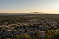
Looking out over the Galisteo Basin at sunset. The Ortiz Mountains, Sandia Mountains, and Manzano Mountains are visible in the background.

