Amistad Dam facts for kids
Quick facts for kids Amistad Dam |
|
|---|---|

Amistad Dam
|
|
| Country | United States / Mexico |
| Location | Val Verde County, Texas / Acuña Municipality, Coahuila |
| Coordinates | 29°27′01″N 101°03′28″W / 29.45028°N 101.05778°W |
| Status | In use |
| Construction began | 1963 |
| Opening date | 1969 |
| Construction cost | US$125 million ($808 million in 2014) |
| Owner(s) | International Boundary and Water Commission |
| Dam and spillways | |
| Type of dam | Earthfill |
| Impounds | Rio Grande |
| Height | 254 ft (77 m) |
| Length | 32,022 ft (9,760 m) |
| Dam volume | 17,055,000 cu yd (13,039,000 m3) |
| Spillway type | Ogee crest, 16 tainter gates |
| Spillway capacity | 1,507,000 cu ft/s (42,700 m3/s) |
| Reservoir | |
| Creates | Amistad Reservoir |
| Total capacity | 5,658,600 acre⋅ft (6.9798 km3) |
| Surface area | 64,900 acres (26,300 ha) |
| Power station | |
| Hydraulic head | 234 ft (71 m) |
| Turbines | 4x Francis |
| Installed capacity | 132 MW |
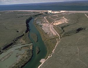
Amistad Dam (Spanish: Presa la Amistad) is a very important dam built across the Rio Grande. This river forms part of the border between Texas, United States, and Coahuila, Mexico. The dam helps store water for farms, control floods, and make electricity. It's the biggest dam along the international part of the Rio Grande. The dam is more than 6 miles (10 km) long. It creates a large lake called Amistad Reservoir. The name "Amistad" means "friendship" in Spanish. This name shows how the two countries worked together on the dam.
The dam is managed by the International Boundary and Water Commission (IBWC). It also has a special crossing point for people and vehicles between the two countries.
Contents
History of Amistad Dam
Why the Dam Was Needed
For a long time, the Rio Grande often had big floods or very dry periods. Sharing its water between the U.S. and Mexico was a tricky problem. In 1906, a special agreement (a treaty) helped build the Elephant Butte Dam in New Mexico. This dam helped people along the middle part of the Rio Grande. But it didn't help the lower part of the river, where water flows were still out of control.
Later, in 1944, another treaty allowed the IBWC to build more dams on the border part of the Rio Grande. The first dam built under this agreement was Falcon Dam in 1953.
Building the Dam
In 1954, the Rio Grande had a huge flood. This showed that an even bigger dam was needed. It would help control the river and two other rivers that flow into it: the Pecos and Devils Rivers. The chosen spot for the new dam was about 1 mile (1.6 km) below where the Devils River joins the Rio Grande. It was also about 12 miles (19 km) upstream from Del Rio.
At first, people called it "Diablo Reservoir." Diablo means "devil" in Spanish, like the Devils River. Both governments approved the final plan in 1960. Work on the dam started in August 1963. They began drilling into the riverbed to prepare for the concrete part of the dam. The actual building of the dam started in January 1965. Water began to fill the reservoir in 1968. U.S. President Richard Nixon and Mexican President Gustavo Díaz Ordaz officially opened the dam in 1969.
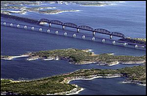
Building the dam meant moving some things. About 14.3 miles (23 km) of Southern Pacific Railroad tracks had to be moved. Also, 19 miles (31 km) of highways and two bridges were relocated. When the reservoir filled up, it covered ancient rock art. This art was made by Native Americans who used to live in the area. Before the water covered them, experts studied and recorded over 170 archaeological sites.
The power plants that make electricity were added later. The U.S. plant was finished in 1983, and the Mexican plant in 1987. The dam cost about $125 million. The U.S. paid about 57% of the cost, and Mexico paid 43%. This was based on how much water each country would get from the reservoir.
How Amistad Dam Works
Dam Structure and Spillways
The Amistad Dam is very long, stretching about 6 miles (10 km). Most of it, about 22,347 feet (6,811 m), is in Mexico. The rest, about 9,585 feet (2,922 m), is in the United States. The middle part of the dam, where it crosses the Rio Grande, is made of concrete. The other parts are made of earth, like a large hill.
The dam is 254 feet (77 m) tall above the riverbed. The top of the dam, where a road runs, is 1,152.3 feet (351.2 m) above sea level. The road on top is 32.8 feet (10 m) wide.
The earth parts of the dam are covered with large rocks called riprap. This protects them from being worn away by water. The dam is built on a type of rock called karstic limestone. To stop water from leaking through the ground under the dam, a very deep underground wall of cement (a grout curtain) was built. Even with this, some water still seeps through the bedrock, but it doesn't harm the dam itself.
When there's too much water, the dam releases it through a special part called a spillway. This spillway has 16 large gates, each 50 by 54 feet (15 by 16 m). These gates can let out a huge amount of water very quickly. The water then flows into a "stilling basin," which is a long area designed to slow down the water and prevent erosion.
Water Supply and Flood Control
The Amistad Reservoir is a huge lake. At its normal water level, it covers about 65,000 acres (26,000 ha). It's one of the biggest lakes in the Rio Grande system. The reservoir holds water for different reasons:
- Water Conservation: 61% of the water is for daily use and to control sediment (dirt) that builds up.
- Flood Control: 32% is kept empty to store extra water during floods.
- Surcharge: 7% is for extreme floods, holding water even above the spillway gates.
At its highest flood level, the reservoir can cover 89,000 acres (36,000 ha). The lowest point where water can be released is 930 feet (280 m) above sea level. When the reservoir is full, it stretches far up the rivers: 78 miles (126 km) up the Rio Grande, 25 miles (40 km) up the Devils River, and 14 miles (23 km) up the Pecos River. The lake has a very long shoreline, about 851 miles (1,370 km).

The United States gets about 56.2% of the water released from Amistad Dam. Mexico gets the other 43.8%. The IBWC checks the water levels every two weeks to make sure each country gets its fair share. The lake's water levels change a lot. This is because the amount of rain changes each year, and people use a lot of water. The highest the lake has ever been was on September 22, 1974. The lowest was on May 23, 2013, after several years of dry weather.
Most of the water flowing into Amistad Reservoir comes from the Rio Grande, Devils, and Pecos Rivers. But about 30% comes from local springs. Water levels usually go up between August and October. This is because of monsoon storms and hurricanes that hit the Gulf Coast. Floods from hurricanes can be very strong, but they don't last long. For example, in September 1974, the dam operators held back a huge amount of water. This stopped a large part of the Rio Grande Valley from flooding.
Because people use a lot of water from the Rio Grande in states like Colorado and New Mexico, the Rio Conchos in Mexico actually provides most of the water that flows into Amistad Lake from the Rio Grande. As more water is used upstream, the amount of water in the Rio Grande has been going down. This makes people worry about future water levels at Amistad.
Making Electricity
The dam has two power plants that make electricity from water (hydroelectric power). One is on the U.S. side, and one is on the Mexican side. Each plant can make 66 megawatts (MW) of power. For the plants to work, the water needs to fall at least 115 feet (35 m). The maximum height the water can fall is 234 feet (71 m).
There are four generators, and each can make 33 MW of power. They are powered by special machines called Francis turbines. These turbines use the force of the falling water to spin and create electricity. When both power plants are running at full power, a lot of water flows through them.
In 2009, the Amistad Dam power plants made a total of 296,734,000 kilowatt-hours of electricity.
Border Crossing at Amistad Dam
The Amistad Dam also has a special crossing point for people and vehicles. It was built when the dam was finished in 1969. This crossing helps people travel between the U.S. and Mexico. In 2005, about 65,000 vehicles crossed the dam into the U.S. The border station was rebuilt in 2012 by the U.S. Army Corps of Engineers.
Recreation at Amistad Dam
The dam and its large lake, the Amistad Reservoir, are part of the Amistad National Recreation Area. This area is a popular spot for outdoor activities like boating, fishing, and camping.
See also
 In Spanish: Presa de la Amistad para niños
 | William M. Jackson |
 | Juan E. Gilbert |
 | Neil deGrasse Tyson |

