
Tecate facts for kids
Quick facts for kids
Tecate, Baja California
|
|
|---|---|
_(cropped).jpg) _(cropped).jpg) _(cropped).jpg) Top: Parque Miguel Hidalgo (left) and President Lázaro Cárdenas Street (right); bottom: aerial view
|
|

Tecate, Baja California
Location in Baja California

Tecate, Baja California
Location in Mexico
|
|
| Country | Mexico |
| State | Baja California |
| Municipality | Tecate |
| Founded | October 12, 1892 |
| Government | |
| • Type | Ayuntamiento |
| Elevation | 540 m (1,770 ft) |
| Population
(2019)
|
|
| • City | 108,860 |
| • Metro | 132,406 |
| Demonym(s) | Tecatense |
| Time zone | UTC−8 (PST) |
| • Summer (DST) | UTC−7 (PDT) |
| Postal codes |
21400–21499
|
| Area code(s) | 665 |
| Website | www.tecate.gob.mx |
Tecate is a lively city in Baja California, Mexico. It sits right across the border from Tecate, California. In 2019, about 108,860 people lived in the city. The larger metropolitan area had around 132,406 residents. Tecate is part of the big San Diego–Tijuana region. It is the largest city between Tijuana and Mexicali. Tecate is an important center for business and a popular place for tourists to visit. It is known for its border crossing, the Tecate Port of Entry. It is also famous as the home of Tecate beer.
Contents
Exploring Tecate's Past
.jpg)
.jpg)
_(cropped).jpg)
Tecate is located in a beautiful valley. This valley is surrounded by many hills and mountains. The most famous mountain is Kuuchamaa Mountain. It is also called Tecate Peak in the United States. This mountain is very special to the Kumeyaay people. They are an indigenous group, also known as Kumiai in Mexico. The Kumeyaay language is still spoken in the mountains near Tecate. Kuuchamaa Mountain is full of green plants, colorful wildflowers, and many birds. People from Tecate and tourists love to hike and bike on its trails.
In 1829, the Mexican governor of Alta California, José María de Echeandía, gave the Tecate valley as a land grant. This land, called Rancho Tecate, was about 4,439 acres. It was given to Juan Bandini. In 1836, the Kumeyaay people, who lived in the mountains, attacked the rancho. They were helped by some former mission workers. They stole animals and burned the ranch house. Bandini had to leave the rancho because of these attacks. He never returned.
In the late 1800s, farmers and ranchers came to Tecate. They found many natural resources. They saw that Tecate had plenty of water and rich soil. This made it perfect for farming. Olives, grapes, and grain became the main crops. Factories also started to grow. Coffee processing plants and breweries were built.
The town of Tecate was officially started on April 2, 1888. It became a city on October 12, 1892. In 1919, Governor Esteban Cantú ordered the first city plan. An engineer named Luis Pavón designed it.
In 1953, Tecate Municipality became separate from Tijuana Municipality. Tecate was chosen as the main city for the new municipality.
Tecate is known for its traditional look. It still has its main plaza in the city center. The city hall and historic church are close by.
Tecate's Geography and Climate
_(cropped).jpg)
Tecate is about 1,770 feet (540 meters) above sea level. Its closeness to the ocean helps give it a mild climate. It rains enough here, about 14 inches (353 mm) each year. This rain helps thick shrubs and scattered trees grow.
A few miles to the east, the climate slowly changes. It goes from a coastal climate to a desert climate. Much of the land east of the city is used for ejidos. These are cooperative farms.
Tecate is also the name of a small river that flows through the city. There is also a small town on the U.S. side of the border. It is called "Tecatito".
Understanding Tecate's Weather
Tecate has hot and dry summers. Winters are cool and sometimes rainy. It has a hot-summer Mediterranean climate. This is known as Csa in the Köppen climate system.
| Month | Jan | Feb | Mar | Apr | May | Jun | Jul | Aug | Sep | Oct | Nov | Dec | Year |
|---|---|---|---|---|---|---|---|---|---|---|---|---|---|
| Record high °C (°F) | 32.0 (89.6) |
32.0 (89.6) |
36.0 (96.8) |
39.0 (102.2) |
42.0 (107.6) |
44.0 (111.2) |
44.0 (111.2) |
47.0 (116.6) |
46.0 (114.8) |
41.1 (106.0) |
39.0 (102.2) |
32.0 (89.6) |
47.0 (116.6) |
| Mean daily maximum °C (°F) | 18.9 (66.0) |
19.6 (67.3) |
20.2 (68.4) |
23.0 (73.4) |
25.5 (77.9) |
29.5 (85.1) |
33.3 (91.9) |
33.7 (92.7) |
32.2 (90.0) |
28.0 (82.4) |
23.0 (73.4) |
19.7 (67.5) |
25.6 (78.1) |
| Daily mean °C (°F) | 11.2 (52.2) |
11.7 (53.1) |
12.6 (54.7) |
14.5 (58.1) |
16.8 (62.2) |
20.1 (68.2) |
23.6 (74.5) |
24.0 (75.2) |
22.3 (72.1) |
18.5 (65.3) |
14.4 (57.9) |
11.8 (53.2) |
16.8 (62.2) |
| Mean daily minimum °C (°F) | 3.4 (38.1) |
3.9 (39.0) |
4.9 (40.8) |
6.1 (43.0) |
8.2 (46.8) |
10.6 (51.1) |
13.9 (57.0) |
14.2 (57.6) |
12.3 (54.1) |
9.0 (48.2) |
5.9 (42.6) |
3.9 (39.0) |
8.0 (46.4) |
| Record low °C (°F) | −9.0 (15.8) |
−8.0 (17.6) |
−5.0 (23.0) |
−2.0 (28.4) |
0.5 (32.9) |
0.0 (32.0) |
2.0 (35.6) |
1.0 (33.8) |
2.0 (35.6) |
−3.0 (26.6) |
−3.0 (26.6) |
−4.0 (24.8) |
−9.0 (15.8) |
| Average precipitation mm (inches) | 74.8 (2.94) |
63.7 (2.51) |
60.7 (2.39) |
28.5 (1.12) |
7.6 (0.30) |
3.6 (0.14) |
3.6 (0.14) |
4.8 (0.19) |
4.6 (0.18) |
14.5 (0.57) |
34.4 (1.35) |
52.4 (2.06) |
353.2 (13.91) |
| Average precipitation days (≥ 0.1 mm) | 6.8 | 6.3 | 5.7 | 4.3 | 1.8 | 0.8 | 0.6 | 0.5 | 0.9 | 2.1 | 3.7 | 5.4 | 38.9 |
| Source: Servicio Meteorologico Nacional | |||||||||||||
People of Tecate
.jpg)
In 2019, Tecate had a population of 108,860 people. This was more than the 72,860 people counted in 2015.
The larger Tecate metropolitan area has about 132,406 residents.
Tecate's Economy and Tourism
Tecate is where the first Tecate Beer brewery was built. Many industrial companies from the U.S. have factories here. These include Rockwell Automation and Ingersoll-Rand.
The city has hospitals and clinics. There are also many doctors and dentists.
Fun Things to Do in Tecate
Tecate has been named a Pueblo Mágico (Magical Town) by Mexico's Secretariat of Tourism. This is because of its rich culture. It is the only Magical Town right on the Mexico–United States border.
- Tecate-to-Ensenada Bicycle Race: Every summer or early fall, a big bicycle race takes place. Thousands of cyclists from both sides of the border join in.
- Los Encinos Park Celebration: In July, there is a two-week festival at Los Encinos Park. It features dance groups, local crafts, food, and exhibits.
- Baseball: Tecate has a stadium called Manuel Ceceña. It is home to the local baseball team, the Cerveceros, which means "Brewers."
Learning in Tecate
.jpg)
Tecate is home to the Autonomous University of Baja California, Tecate campus. This university has an engineering school.
Every year, Tecate holds a special competition for 5th-grade students. They share their ideas to improve their community. The best idea from Tecate competes against winners from other cities in the state. The state winner then competes with winners from other states. The overall winner gets to meet the President of Mexico!
Getting Around Tecate

Tecate is on a branch of Mexican Federal Highway 2. This highway connects Tijuana with Mexicali. It goes through the central Sierra mountains. Tecate is on the older, two-lane road, which does not have tolls.
A train called the Tecate Ticket used to travel from Campo, California, to Tecate once a month. This train is run by the Pacific Southwest Railway Museum. However, it is currently stopped due to a tunnel fire.
Tecate has its own airport, the Tecate Airport. But it is no longer used much because of low passenger traffic. Most Tecate residents use the nearby Tijuana International Airport (TIJ). This airport has flights to many major Mexican cities. TIJ is closer to Tecate than Mexicali International Airport.
Images for kids
-
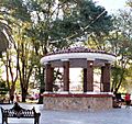
Parque Miguel Hidalgo
-
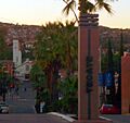
Welcome sign
-
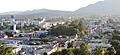
Aerial view of Tecate
See also
 In Spanish: Tecate para niños
