
Tijuana Municipality facts for kids
Quick facts for kids
Tijuana Municipality
|
||
|---|---|---|
|
Municipality
|
||
| Municipio de Tijuana Municipality of Tijuana |
||
|
||
| Motto(s):
The Fatherland Starts Here
|
||

Location of Tijuana in Baja California
|
||
| Country | United Mexican States | |
| State | Baja California | |
| Municipal seat | Tijuana | |
| Largest city | Tijuana | |
| Municipality established | December 29, 1953 | |
| Government | ||
| • Body | Ayuntamiento | |
| Area | ||
| • Total | 879.2 km2 (339.5 sq mi) | |
| Population
(2020)
|
||
| • Total | 1,922,523 | |
| Data source: | ||
| Time zone | UTC−8 (Northwest (US Pacific)) | |
| • Summer (DST) | UTC−7 (Northwest) | |
| INEGI code | 004 | |
| Website | Ayuntamiento de Tijuana | |
| Source: Enciclopedia de los Municipios de México | ||

The Tijuana Municipality is a special area in the Mexican state of Baja California. It's like a county, and its main city is Tijuana. In 2020, about 1.9 million people lived here.
The current mayor, or municipal president, is Montserrat Caballero. She is part of the MORENA political party. This municipality includes a big part of the Tijuana metropolitan area, which is a large city region.
Tijuana Municipality shares its borders with other areas. To the south, it meets Rosarito Beach and Ensenada. To the east, it borders Tecate. The Pacific Ocean is to its west. To the north, it has an international border with the United States, specifically San Diego County in California.
The municipality covers an area of 879.2 square kilometers (about 339.46 square miles). It even includes some islands called the Coronado Islands, which are off the coast in the Pacific Ocean. The city of Tijuana is located just south of San Diego, California.
Contents
- What are the Boroughs of Tijuana?
- Exploring Tijuana's Main Boroughs
- Centro: The Heart of Tijuana
- Cerro Colorado: The Red Hill
- La Mesa: Parks and Universities
- Otay Centenario: Airport and Factories
- Playas de Tijuana: Beaches and Border
- La Presa: The Dam Borough
- San Antonio de los Buenos: Residential Areas
- Sanchez Taboada: Homes and Factories
- La Presa Este: More Homes
- Resto de Municipio: The Rural Part
- Exploring Tijuana's Main Boroughs
- How Many People Live in Tijuana Municipality?
- Images for kids
- See also
What are the Boroughs of Tijuana?
The Tijuana Municipality is divided into nine administrative areas called delegaciones, or boroughs. Think of them as smaller districts within the municipality. There's also a large "Resto de Municipio" area, which is mostly rural.
Each borough has its own local office and a leader called a delegado. These offices help with things like city planning, keeping official records, and managing public projects. The main city of Tijuana covers all the borough seats.
Exploring Tijuana's Main Boroughs
Let's take a closer look at some of these important boroughs:
Centro: The Heart of Tijuana
- Centro is the central borough. It includes the old downtown area, called Zona Centro, and a new business district known as Zona Río. This is the historical center of Tijuana. The main government building, the municipal palace, is here. Many tourist spots, like Avenida Revolución, are also in Centro. You can also find the Tijuana Cultural Center (CECUT) and Plaza Río Tijuana, a large shopping mall, in Zona Río.
Cerro Colorado: The Red Hill
- Cerro Colorado is named after the "Red Hill" located here. This hill is surrounded by homes. Because it's so tall, many radio and television antennas are placed on its peak.
La Mesa: Parks and Universities
- La Mesa is home to Morelos Park, which is the biggest public park in the city. You'll also find Plaza Mundo Divertido, a new shopping center called Macroplaza, and CETYS University here.
Otay Centenario: Airport and Factories
- Otay Centenario was created in 2014 by combining two older boroughs. The Tijuana International Airport is located here. This borough also has the Tijuana campus of the Autonomous University of Baja California and the Technologico university. Many factories, called maquiladoras, are found here, especially in an area known as Ciudad Industrial (Industrial City). Important roads like Boulevard Bellas Artes and Boulevard Industrial run through this area. The Otay Mesa Port of Entry, a border crossing, and Parque de la Amistad (Friendship Park) are also here.
Playas de Tijuana: Beaches and Border
- Playas de Tijuana is the westernmost borough. It's bordered by the Pacific Ocean to the west and the United States border to the north. This is where Tijuana's beaches are located, which is how it got its name ("Playas" means "Beaches"). It's also one of the main routes to travel south towards Rosarito and Ensenada.
La Presa: The Dam Borough
- La Presa is the largest borough in size. The Abelardo L. Rodríguez Dam is located within its borders, which is why it's called "La Presa" (meaning "The Dam"). The new Corredor Tijuana 2000 road and the free road to Tecate pass through this area.
San Antonio de los Buenos: Residential Areas
- San Antonio de los Buenos is mostly a residential area, meaning many people live here. It also has two industrial parks.
Sanchez Taboada: Homes and Factories
- Sanchez Taboada is another borough that is mostly residential. However, it also has many maquiladoras (factories), especially in the Pacific Industrial Park.
La Presa Este: More Homes
- La Presa Este is also mainly a residential area, similar to San Antonio de los Buenos and Sanchez Taboada.
Resto de Municipio: The Rural Part
- Resto de Municipio means "Rest of Municipality." This is the largest part of the municipality and is mostly rural. It has small towns located in the southernmost areas that are not part of the main city.
How Many People Live in Tijuana Municipality?
| Historical population | ||
|---|---|---|
| Year | Pop. | ±% |
| 2000 | 1,210,820 | — |
| 2005 | 1,410,700 | +16.5% |
| 2010 | 1,559,683 | +10.6% |
| 2015 | 1,641,570 | +5.3% |
| 2020 | 1,922,523 | +17.1% |
| sources: | ||
In 2020, the total population of Tijuana Municipality was 1,922,523 people.
In 2010, the city of Tijuana itself had about 1,300,983 residents. The municipality also includes many other smaller towns and communities. Some of the larger ones in 2010 were El Refugio (36,400 people), Pórticos de San Antonio (34,234), and La Joya (26,860).
Images for kids
-
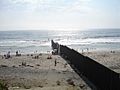
View of the U.S.–Mexico border fence from Playas de Tijuana, at the left

See also
 In Spanish: Municipio de Tijuana para niños
