
San Ysidro Port of Entry facts for kids
Quick facts for kids San Ysidro Port of Entry |
|
|---|---|

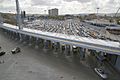
San Ysidro Border Inspection Station in 2011
|
|
| Location | |
| Country | United States |
| Location |
|
| Coordinates | 32°32′36″N 117°01′47″W / 32.54333°N 117.02972°W |
| Details | |
| Opened | 1906 |
| Hours | Open 24 Hours |
| Exit Port | El Chaparral |
| Statistics | |
| 2019 Cars | 14,979,363 |
| 2019 Individuals | 53,296,133 |
| 2019 Pedestrians | 10,799,398 |
The San Ysidro Port of Entry is a very important border crossing. It's the biggest land crossing between San Diego, USA, and Tijuana, Mexico. It's also one of the busiest land border crossings in the world. About 70,000 vehicles and 20,000 people cross from Mexico into the U.S. here every day. Many people also cross from the U.S. into Mexico. This port connects Mexican Federal Highway 1 in Mexico with Interstate 5 in the United States. It's one of three main border crossings in the San Diego–Tijuana area.
Crossing the Border
There are different ways to cross the border at San Ysidro. You can cross by car or on foot. There are lanes for cars going north (into the U.S.) and south (into Mexico). There are also separate paths for people walking across.
Northbound Car Lanes
When you drive from Mexico into the U.S., you use the northbound vehicle lanes. There are currently 34 lanes for cars to cross here. This helps manage the large number of vehicles.
Southbound Car Lanes (El Chaparral)
The lanes for cars going from the U.S. into Mexico are called El Chaparral. These lanes were moved to a new spot. This move made space for new buildings and more lanes for cars going north. At El Chaparral, U.S. and Mexican officials can check cars and people going south. This helps make sure everything is safe and organized.
Main Pedestrian Crossing (East)
People walking from Mexico into the U.S. can use the main pedestrian crossing. It's located just east of the car lanes. There are 15 lanes for pedestrians, and more are being added.
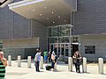
For people walking from the U.S. into Mexico, there's a special building. It's called the Puerta Este México-San Ysidro building. It opened in 2015 and has Mexican passport control and customs.
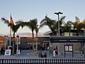
PedWest (Western Pedestrian Crossing)
The PedWest crossing is another way for people to walk across the border. It's located west of the main crossing. PedWest opened in 2016 for people going north. It opened in 2017 for people going south. This crossing has 10 lanes for northbound walkers and 2 lanes that can go either way. It helps make crossing faster for many people.
Temporary Closure of PedWest
PedWest was closed in April 2020 because fewer people were crossing due to the COVID-19 pandemic. It reopened in January 2023 with limited hours.
-
San Ysidro Port of Entry, 2016.
-
PedWest building, U.S. side, July 2017.
-
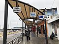
Photo taken in Tijuana on walking path to San Ysidro Land Port of Entry, East Pedestrian Facility.
-
San Ysidro Land Port of Entry
East Pedestrian Facility
Travelers exiting on U.S. side. -
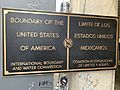
Plaque at the San Ysidro Port of Entry, indicating the Mexico–United States border.
-

Photo of the sign on the East Pedestrian Facility at the San Ysidro Land Port of Entry.
.jpg)


History of the Crossing
There has been a border crossing station in San Ysidro since the early 1900s.

At first, cars, people, trucks, and even trains were checked here. In the 1950s, it got too crowded. So, truck traffic was moved to a different crossing nearby. Later, in 1983, the Otay Mesa Port of Entry opened. Now, all trucks cross at Otay Mesa.
In 1933, a special building called the Old Customs House was built. It was made in a beautiful Mission Revival style. This building is still used today for offices.
_front.JPG)
The current San Ysidro crossing facility was built in the 1970s. It was designed to handle the growing number of people and cars. This port is known as the busiest international crossing in the world. It sees the most individual people and vehicles moving between two countries.
With over 90,000 people crossing daily, it can be challenging. People sometimes wait for hours to enter the United States. Border officials say new technology and checking everyone carefully can cause long lines.
Border Event in 2018
On November 25, 2018, some groups of people tried to cross the border. They were part of larger groups of migrants from Central America. Some people threw rocks at U.S. Border Patrol agents. The agents responded by using tear gas. This included areas where families with children were present. The Mexican government protested this action. They asked for a full investigation.
Expansion Project
| Proposed San Ysidro Port Facility | |
|---|---|

Aerial view of artist's rendering of the finished San Ysidro Land Port of Entry in 2015.
|
|
| General information | |
| Status | Complete |
| Type | Administrative, Immigration and Customs Inspection |
| Location | San Diego, CA |
| Construction started | December 2009 |
| Opened | December 23, 2019 |
| Technical details | |
| Floor count | 4 |
| Floor area | 225,000 sq ft (20,903 m2) of office space, 110,000 sq ft (10,219 m2) of inspection operations space |
| Design and construction | |
| Architect | Miller Hull Partnership |
| Developer | General Services Administration |
The San Ysidro Land Port of Entry Expansion Project was a big plan. It was a joint effort between the United States and Mexico. The goal was to update and expand the border crossing. This included tearing down old buildings and building new ones. The project cost about $625 million. Most of this money went to the U.S. side.
The project was done in three main parts:
- Phase I: This part added more lanes for cars going north. It also improved the inspection areas.
- Phase II: This involved building a new, larger office building. A parking garage for employees was also built. A new building for people walking across the border was constructed too.
- Phase III: This moved the lanes for cars going south into Mexico. This made more space for new buildings and more northbound lanes. The new location allows U.S. officials to check cars going into Mexico. Mexican officials also greet vehicles at a new, better-equipped station called Puerta Mexico El Chaparral.
After the project was finished, the number of northbound car lanes increased. There are now 62 lanes in total. The project also added new, energy-saving materials to the buildings. It also made the SENTRI lanes more efficient.
Construction Milestones
- 2011
- A new pedestrian bridge was finished on the U.S. side in February 2011.
- In September 2011, part of the construction collapsed. It fell onto cars crossing the border. Nine people were hurt. All northbound traffic was sent to the Otay Mesa Port of Entry that day. This caused huge traffic jams.
- 2013
- On the Tijuana side, new roads were built in 2013. These roads connect the new El Chaparral facility to major highways.
- 2015
- In August 2015, Mexico opened a new pedestrian crossing facility. It's on the east side of the crossing. For the first time, people entering Mexico at the border needed to show their passports.
- 2016
- On July 15, 2016, the PedWest pedestrian crossing opened. On the Mexican side, a walkway was built to connect PedWest to the Plaza Viva Tijuana mall. This walkway was later replaced with a stronger, permanent one.
- 2017–2019
- Phase III of the project began in September 2017. It was finished in December 2019. This phase added more inspection lanes for cars going north. Architects Miller Hull Partnership led this part of the project.
See also
 In Spanish: Garita Internacional de San Ysidro para niños
- List of Mexico–United States border crossings
- List of Canada–United States border crossings
