Cypress Island facts for kids

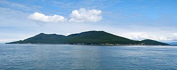
Cypress Island from Rosario Strait
|
|

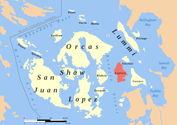
Cypress Island within the San Juan Islands
|
|
| Geography | |
|---|---|
| Location | Salish Sea |
| Coordinates | 48°34′28″N 122°42′16″W / 48.57433°N 122.70453°W |
| Area | 8.6 sq mi (22 km2) |
| Length | 4.75 mi (7.64 km) |
| Width | 3.5 mi (5.6 km) |
| Highest elevation | 1,525 ft (464.8 m) |
| Administration | |
|
United States
|
|
| State | Washington |
| County | Skagit County |
| Demographics | |
| Population | 40 (2000) |
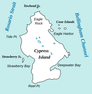
Cypress Island is a beautiful island located in Skagit County, Washington. It sits between the mainland and the San Juan Islands. To its west is Blakely Island, separated by Rosario Strait. To its east is Guemes Island, across Bellingham Channel.
Cypress Island covers about 5,500 acres (22 square kilometers). In the year 2000, only 40 people lived there. Most of the island, about 5,100 acres (21 square kilometers), is managed by the Washington Department of Natural Resources. They keep the island in a natural state.
The island is covered in thick forests and has many trails. These trails connect different parts of the island. There is also a small lake, about 7 acres (28,000 square meters), in the middle of the island. On the southeast side, there is a calm bay with a salmon fish farm. Cypress Island does not have a ferry service or public utilities like electricity or water.
Many people enjoy visiting Cypress Island for kayak trips. It is quite close to the mainland. There are two camping spots on the east side for visitors. Boaters can find safe places to anchor in Eagle Harbor. This area also has public state park facilities.
Contents
Island Nature: Trees and Rocks
Most of Cypress Island has a special type of rock called serpentinite. This rock makes the soil poor in some important plant nutrients. The most common soil on the island is called Guemes very stony loam. However, some areas, especially in the north, have more fertile soil.
The forests on Cypress Island are mostly made up of Douglas fir trees. Because of the magnesium-rich rock, you can also find many Seaside Juniper trees. Other common trees include shore pine, Pacific madrone, and Douglas maple. You might also see some Western hemlock, western red cedar, grand fir, Red alder, and Bigleaf maple.
Island History: Past and Present
Native People on Cypress Island
Before settlers arrived in the early 1900s, the Samish tribe used Cypress Island. They had a winter village on nearby Guemes Island. The Samish people also had fishing villages on Cypress Island until about 1900.
Early European Visitors
The first Europeans to see Cypress Island were the Spanish in 1791. They were on a trip led by José María Narváez. He named the island San Vincente.
Later, in June 1792, Captain George Vancouver named the island again. He thought the juniper trees looked like cypress trees. One of Vancouver's ships, the Chatham, even lost an anchor in Strawberry Bay on the west side of the island. Vancouver wrote that Cypress Island has "high rocky mountains and steep perpendicular cliffs." He also noted "small runs of most excellent water" flowing into Strawberry Bay.
Protecting the Island
In 1975, the Washington Department of Natural Resources (DNR) set aside 156 acres (0.6 square kilometers) of the island as a Natural Area Preserve. They added 56 more acres in 1978. But at that time, most of the island was still privately owned.
There were several plans to develop the island. For example, in 1978, a businessman named Raymond Alvah Hanson bought 3,150 acres (13 square kilometers) on Cypress Island. In the 1980s, he wanted to build a large public utility or even a fancy resort and golf course. However, small landowners on the island formed a group called "Friends of Cypress Island." They fought against these development plans.
Finally, in 1989, Hanson sold his land to the Department of Natural Resources. This purchase, along with other smaller land buys, helped expand the Natural Area Preserve to 1,073 acres (4.3 square kilometers). This is part of the larger Cypress Island Natural Resources Conservation Area, which covers 5,100 acres (21 square kilometers).
In 2007, the waters around Cypress Island also became a DNR Aquatic Reserve. This helps protect the marine life around the island.
See also
 In Spanish: Isla Cypress (Washington) para niños
 | Selma Burke |
 | Pauline Powell Burns |
 | Frederick J. Brown |
 | Robert Blackburn |


