Clayoquot Sound facts for kids
Quick facts for kids Clayoquot Sound |
|
|---|---|
| French: Baie Clayoquot | |
 |
|

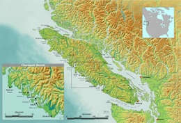
Map of Vancouver Island with inset of Clayoquot Sound region
|
|
| Location | Vancouver Island, British Columbia |
| Coordinates | 49°12′00″N 126°06′00″W / 49.20000°N 126.10000°W |
| Type | Sound |
| Ocean/sea sources | Pacific Ocean |
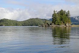
Clayoquot Sound is a beautiful area on the west coast of Vancouver Island in British Columbia, Canada. It's a large body of water with many smaller inlets and islands. Some of the main islands are Flores Island, Vargas Island, and Meares Island. The name "Clayoquot Sound" also refers to the entire land region around this water, including its rivers and forests.
| Top - 0-9 A B C D E F G H I J K L M N O P Q R S T U V W X Y Z |
Where Does the Name Clayoquot Come From?
The name Clayoquot comes from a group of Indigenous people called the Nuu-chah-nulth. This specific group lived in an area known as Clayoqua.
Later, this group joined with others to form the Tla-o-qui-aht First Nation. In their language, "Tla-o-qui-aht" means "different" or "changing."
A Look Back in Time: The History of Clayoquot Sound
The Clayoquot Sound area has been home to First Nations people for thousands of years. Evidence shows people lived here over 4,200 years ago. Scientists believe people might have lived here even longer, perhaps over 9,000 years ago.
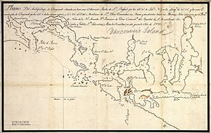
In the late 1700s, European and American explorers arrived by ship. They were mainly interested in the fur trade. In 1791, explorers like José María Narváez and Juan Carrasco mapped the inner waters. Their leader, Francisco de Eliza, even met and became friends with Wickaninnish, a chief of the Tla-o-qui-aht people.
These explorers quickly saw how rich the region was in natural resources. More and more non-First Nations people came to use these resources. This limited the First Nations' access to their traditional lands. Over time, logging companies became very active in the Clayoquot Sound area, especially in the 1980s and 1990s.
The Clayoquot Protests: Standing Up for the Land
In the late 20th century, First Nations people started working harder to protect their rights and resources. They formed groups to speak up and demanded discussions about how the land was being used. Things became more serious in the late 1980s when the government allowed a company to log on Meares Island.
From 1980 to 1994, First Nations people and their supporters protested peacefully. They blocked logging roads to stop the work. In the summer of 1993, over 800 protestors were arrested. Many were put on trial for stopping the logging.
These protestors included members of the local Tla-o-qui-aht and Ahousaht First Nations. Environmental groups like Greenpeace and Friends of Clayoquot Sound also joined in. News channels around the world covered these protests. This helped people across Canada support environmental movements. Many felt it was unfair that peaceful protestors were being arrested.
After the protests, the government made a big change. They asked a group of scientists to study the issues in Clayoquot Sound. In 1995, the government officially accepted 127 recommendations from this group.
Greenpeace played a big part by asking people not to buy forest products from British Columbia. Once the government agreed to the scientific recommendations, Greenpeace stopped the boycott. The government then reduced how much logging could happen. They also limited clear-cuts (where all trees are cut down) to small areas. Now, logging plans must consider both nature and culture.
Indigenous Peoples and Their Governments
Three main First Nations groups of the Nuu-chah-nulth people live in Clayoquot Sound. These are the Hesquiaht in the north, the Ahousaht in the middle, and the Tla-o-qui-aht in the south. The Tla-o-qui-aht are based in the village of Opitsaht on Meares Island. The town of Tofino is located across from Opitsaht.
In 1985, for the first time in British Columbia, courts stopped resource development on government land. This happened because of a land claim by Indigenous people. Chiefs from the Ahousaht and Tla-o-qui-aht First Nations got a court order to stop logging on Meares Island. They wanted to negotiate a treaty with the government first.
These negotiations led to the Interim Measures Act (IMA) being signed in 1994. Since then, First Nations and the government have worked together to manage the land and its resources. This includes planning for economic growth in the area.
With less logging happening, communities like Tofino, Ucluelet, and Ahousaht have found new ways to earn money. They are focusing on ecotourism (tourism that protects nature) and careful, selective logging.
Nature and Parks of Clayoquot Sound

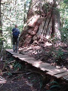
The land around Clayoquot Sound is amazing. It has huge coastal rainforests, rivers, lakes, ocean areas, and beaches. Part of the Pacific Rim National Park Reserve and some of Strathcona Provincial Park are also here. The total size of the Clayoquot Sound region, including land and water, is about 350,000 hectares.
Scientists have studied over 200,000 hectares of the area. They look for places that might have landslides or soil erosion. This region has the largest area of untouched temperate rainforest left on Vancouver Island.
Clayoquot Sound is home to many animals, including:
- Wolves
- Black bears
- Cougars
- Grey whales
- Orcas
- Porpoises
- Seals
- Sea lions
- River otters
- Bald eagles
- Osprey
- Marbled murrelets
- Pacific loons
- Roosevelt elk
- Martens
- Raccoons
In 2000, Clayoquot Sound Biosphere Reserve was named a Biosphere Reserve by UNESCO. This means the world recognized Clayoquot Sound for its amazing variety of life. A special fund of $12 million was set up to help with research, education, and training in the area.
In 2006, new plans for the watersheds in Clayoquot Sound were approved. This allowed some logging in about 10,000 hectares of forest, including old-growth valleys. As of 2007, Indigenous-owned logging companies manage the logging rights in Clayoquot Sound. They are Iisaak Forest Resources and MaMook Natural Resources Ltd.
 | Roy Wilkins |
 | John Lewis |
 | Linda Carol Brown |


