Namu, British Columbia facts for kids
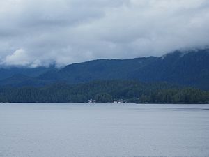
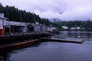
Namu is a small fishing port and a former fish canning town on the coast of British Columbia, Canada. It's also an important First Nations community. Namu is located about 95 kilometers (59 miles) southwest of Bella Coola. It's also about 35 kilometers (22 miles) southeast of Bella Bella. You can find it on the mainland shore of the Inside Passage, a popular ferry route. It's directly across from Hunter Island. Just south of Namu, you'll find the entrance to Burke Channel and King Island. The community's harbor is called Namu Harbour. A large lake nearby is Namu Lake. This lake feeds the 15-kilometer (9.3-mile) Namu River. East of the river is the rugged Namu Range.
Namu is famous for a killer whale named Namu. This orca was caught near here in 1965. He was only the second killer whale ever displayed in a marine park.
Ancient History of Namu

The area where Namu sits is one of the oldest known human settlements on the British Columbia coast. People lived here as far back as 10,000 to 5,800 years Before Common Era (BCE). These early people were skilled marine hunters. They relied on the ocean for their food and way of life.
Archaeologists have found tools and evidence from this time. These findings show that people had a strong "marine economy" by 6000 BP (4000 BCE). This means they were very good at getting food from the sea. Tiny, sharp stone tools called "microblades" appeared at Namu around 8250 BCE. This was the southernmost place along the coast where these tools were commonly used. Simple "pebble tools" were also found here. This suggests Namu was a meeting point for different tool-making traditions.
At first, there's no clear sign of large, permanent houses. This is likely because the sea level was changing a lot along the coast. After 5800 BCE, glaciers melted, and rivers became stable. This created new places for salmon to lay their eggs. Large salmon runs then became a major food source. Later, around 2500 BCE, salmon fishing became a bit less common. This was due to changes in river mouths and sand building up.
Even later, the sea level became more stable. This led to the growth of large tidal flats. People could then add shellfish to their main food sources. This way of life continued until about 1250 BCE.
Shell Middens and Burials
Archaeologists often find old remains in "shell middens." These are piles of discarded shells and other waste from ancient meals. Shell middens are great for preserving things because they are alkaline. This means they help stop things from decaying.
At Namu, an important burial site was found within a shell midden. It dates back to around 3400 BCE. Finding this cemetery for hunter-gatherers is important. It shows that these people lived in one place for a long time. This is a sign of "complex hunter-gatherers."
Many different stone tools have been found at Namu. These include tools like "celts" (stone axes), microblades, and "burnishing stones" (for polishing). Many of these tools were made from materials found nearby. These materials included antlers, bone, and various rocks.
Climate Around Namu
The climate near Namu is generally mild and wet. The weather data below comes from Addenbroke Island, which is about 28 kilometers (17 miles) south of Namu.
| Climate data for Addenbroke Island (1981–2010) | |||||||||||||
|---|---|---|---|---|---|---|---|---|---|---|---|---|---|
| Month | Jan | Feb | Mar | Apr | May | Jun | Jul | Aug | Sep | Oct | Nov | Dec | Year |
| Record high °C (°F) | 19.5 (67.1) |
17.5 (63.5) |
19.0 (66.2) |
21.5 (70.7) |
29.0 (84.2) |
31.0 (87.8) |
26.5 (79.7) |
28.5 (83.3) |
25.5 (77.9) |
21.5 (70.7) |
17.5 (63.5) |
17.5 (63.5) |
31.0 (87.8) |
| Mean daily maximum °C (°F) | 7.0 (44.6) |
7.6 (45.7) |
9.0 (48.2) |
11.2 (52.2) |
13.9 (57.0) |
16.1 (61.0) |
17.9 (64.2) |
18.3 (64.9) |
15.9 (60.6) |
12.0 (53.6) |
8.5 (47.3) |
7.0 (44.6) |
12.0 (53.7) |
| Daily mean °C (°F) | 4.7 (40.5) |
4.9 (40.8) |
6.1 (43.0) |
8.0 (46.4) |
10.6 (51.1) |
13.0 (55.4) |
14.9 (58.8) |
15.2 (59.4) |
13.0 (55.4) |
9.6 (49.3) |
6.2 (43.2) |
4.7 (40.5) |
9.2 (48.7) |
| Mean daily minimum °C (°F) | 2.2 (36.0) |
2.2 (36.0) |
3.2 (37.8) |
4.7 (40.5) |
7.3 (45.1) |
9.9 (49.8) |
11.8 (53.2) |
12.1 (53.8) |
10.1 (50.2) |
7.1 (44.8) |
3.8 (38.8) |
2.3 (36.1) |
6.4 (43.5) |
| Record low °C (°F) | −10.5 (13.1) |
−15.0 (5.0) |
−7.5 (18.5) |
−0.5 (31.1) |
1.0 (33.8) |
5.0 (41.0) |
7.5 (45.5) |
7.8 (46.0) |
3.5 (38.3) |
−7.0 (19.4) |
−16.0 (3.2) |
−10.5 (13.1) |
−16.0 (3.2) |
| Average precipitation mm (inches) | 405.7 (15.97) |
266.1 (10.48) |
263.2 (10.36) |
236.1 (9.30) |
162.4 (6.39) |
158.0 (6.22) |
108.7 (4.28) |
138.2 (5.44) |
228.1 (8.98) |
432.0 (17.01) |
496.4 (19.54) |
367.4 (14.46) |
3,262.3 (128.43) |
| Average snowfall cm (inches) | 13.0 (5.1) |
16.8 (6.6) |
5.9 (2.3) |
1.8 (0.7) |
0.0 (0.0) |
0.0 (0.0) |
0.0 (0.0) |
0.0 (0.0) |
0.0 (0.0) |
0.7 (0.3) |
4.8 (1.9) |
14.5 (5.7) |
57.5 (22.6) |
| Average precipitation days (≥ 0.2 mm) | 22.8 | 19.3 | 22.3 | 20.9 | 18.3 | 17.4 | 14.5 | 15.9 | 17.5 | 23.5 | 24.2 | 23.5 | 240.1 |
| Average snowy days (≥ 0.2 cm) | 2.5 | 2.5 | 1.7 | 0.58 | 0.0 | 0.0 | 0.0 | 0.0 | 0.0 | 0.08 | 1.2 | 2.8 | 11.3 |
| Source: Environment and Climate Change Canada | |||||||||||||
 | Frances Mary Albrier |
 | Whitney Young |
 | Muhammad Ali |


