
Lake Whatcom facts for kids
Quick facts for kids Lake Whatcom |
|
|---|---|
 |
|

Lake Whatcom
Location in Washington (state)

Lake Whatcom
Location in the United States
|
|
| Location | Whatcom County, Washington |
| Coordinates | 48°43′59″N 122°19′41″W / 48.73306°N 122.32806°W |
| Primary outflows | Whatcom Creek |
| Catchment area | 145 km2 (56 sq mi) |
| Basin countries | United States |
| Max. length | 13 mi (21 km) |
| Max. depth | 350 ft (110 m) |
| Surface elevation | 314 ft (96 m) |
| Islands | 1 (Reveille Island) |
Lake Whatcom gets its name from the Lummi word for "loud water." This important lake is found in Whatcom County, Washington, in the United States. It provides drinking water for about 85,000 people. These people live in the city of Bellingham and other parts of Whatcom County.
The lake is about 10 miles (16 km) long and 1 mile (1.6 km) wide at its widest point. Three different groups help manage Lake Whatcom: the city of Bellingham, Whatcom County, and the Lake Whatcom Water and Sewer District. Many people enjoy visiting the lake for fun activities like motor boating, swimming, and fishing.
Contents
Lake Whatcom's Three Basins
Lake Whatcom is like three connected bowls, called basins. Each basin is a bit different.
Basin 1: The Silver Beach Area
Basin 1 is the northernmost part of the lake. It is also known as the Silver Beach Basin. This area is about 100 feet (30 meters) deep at its deepest point. Most of the land around Basin 1 has homes built on it. There is also one large park and several smaller parks nearby.
Basin 2: The Geneva Area
Basin 2 is in the middle of the lake. This is where the city of Bellingham gets its drinking water from. It is the shallowest part of the lake, only about 40 to 60 feet (12 to 18 meters) deep. Like Basin 1, this area has many homes. There are also some areas protected for the lake and some forests.
Basin 3: The Deepest Part
Basin 3 is the southernmost and most distant part of Lake Whatcom. It is the deepest basin, reaching about 328 feet (100 meters) down. This basin holds about 96% of all the water in the lake! You'll find some homes here, especially in the community of Sudden Valley. There are also many rural and commercial forests around this basin. The entire area that drains water into Lake Whatcom is about 142 square kilometers (55 square miles).
Water Flow and Reveille Island
Many streams and creeks flow into Lake Whatcom. There are nine main streams and about 25 smaller ones. These create 23 smaller areas that drain water into the lake. Water then flows out of Lake Whatcom into Bellingham Bay through Whatcom Creek.
The lake has only one island, called Reveille Island. It is about 3 acres (1.2 hectares) in size. A camp called Camp Firwood owns the island. People believe that Native Americans once held special ceremonies on the island. This is because pictographs (rock paintings) and a stone bowl shaped like an animal were found there.
A Glimpse into Lake Whatcom's Past
The first known people to live near Lake Whatcom were the Saquantch tribe. They were part of the Northwest Coast Salish people and had a village at the south end of the lake. Around the year 1800, the Lummi tribe moved into the area.
The first Western settlers arrived in the 1850s. They bought private land for as little as $8. By the late 1800s, much of the land around the lake was heavily logged for timber. There were also large coal mines near the lake. The Whatcom Mining Company closed its operations in 1919.
In 1946, a man named J.H. Bloedel gave 12.5 acres of land to the city. This land later became Bloedel Donovan Park, a popular spot today. In 1962, water was sent from the Middle Fork of the Nooksack River through a tunnel to supply a new paper mill in Bellingham.
Lake Whatcom as a Reservoir

Lake Whatcom acts like a giant storage tank, or reservoir, for Bellingham's drinking water. The city actively controls the lake's water level using special gates. They manage how much water flows out to make sure there's enough drinking water. They also keep the water level high enough to store incoming water and ensure enough flow in Whatcom Creek for the threatened Chinook salmon.
The drinking water from Lake Whatcom is very clean. It meets all the standards for chemicals, bacteria, and cloudiness. Bellingham is part of a group called the Partnership for Safe Water. The city's drinking water even meets the higher standards set by this group. For many years, the City of Bellingham Public Works has received awards for providing safe drinking water.
Protecting Lake Whatcom from Pollution
In 1998, Lake Whatcom was listed as an "impaired water body" by the United States Environmental Protection Agency. This was because of low levels of dissolved oxygen (DO) in the water. These low oxygen levels are linked to too much phosphorus entering the lake. Low DO levels don't directly affect drinking water quality, but they can harm the lake's ecosystem.
To fix this, the Washington State Department of Ecology (DOE) created a computer model. This model helps figure out the maximum amount of phosphorus the lake can safely receive. In 2008, the DOE estimated that to get oxygen levels back to normal, the amount of hard surfaces (like roads and roofs) that cause runoff needed to be reduced to what they were before 1988.
Most of the phosphorus gets into the lake from "non-point sources." This means it comes from many different places, like rainwater runoff from parks and land around the lake. A small amount comes from lawns, gardens, and streets. Old septic systems near the lake might also leak phosphorus into the water.
To help reduce pollution, fertilizers containing phosphorus were banned in 2005. The city of Bellingham and Whatcom County also limit building activities, like clearing land, from October 1 to May 31 each year. This helps stop soil from washing into the lake during rainy months.
From 2010 to 2014, a special plan was put in place to manage Lake Whatcom. The city of Bellingham, Whatcom County, and the Lake Whatcom Water & Sewer District all approved this plan. They prepare yearly reports to show how they are doing in protecting the lake.
How Lake Whatcom's Water Moves
Lake Whatcom is a "monomictic" lake. This means its water layers mix completely once a year. For part of the year (late spring to mid-fall), the lake has layers. The top layer, called the epilimnion, is warmed by the sun. Below it is the metalimnion, where the water temperature drops quickly. Then comes the hypolimnion, the bottom layer, which is much colder and mostly separate.
Very little oxygen from the air reaches the hypolimnion. This causes very low oxygen levels in the deeper parts of the lake. Sometimes, there's almost no oxygen at all. This layering is strongest in Basin 3 because it's the deepest. The layers and the natural "sills" (underwater ridges) between the basins cause the water to move very slowly through the lake.
Another interesting thing that happens in Lake Whatcom is called a "seiche." A seiche is like a slow sloshing of water from one side of the lake to the other. In Lake Whatcom, strong winds push water to one side, making the water level rise there and drop on the other side. When the wind stops, the water bounces back and forth until it settles. This up-and-down movement can cause the cold, low-oxygen water from Basin 3 to spill over into Basin 2.
Most of the water leaves Lake Whatcom through Whatcom Creek (77.5%). Some is taken by the city of Bellingham for drinking (11.3%). Some evaporates (7.9%), and a small amount goes to a fish hatchery (2.5%). It takes about 7.4 years for water entering the lake to leave it.
Unwanted Guests: Invasive Species
Invasive species are plants or animals that are not native to an area and can cause harm. Some invasive species that could be a big threat to Lake Whatcom include the zebra mussel, New Zealand mud snail, Asian carp, and a fish disease called viral hemorrhagic septicemia (VHS). Luckily, none of the 15 species that Washington state calls "most unwanted" are currently in Lake Whatcom.
However, one unwanted species, Eurasian water milfoil, is known to be in the lake. This is a type of plant that can grow very quickly and cover the surface of the water.
Fish in Lake Whatcom
Lake Whatcom is home to 13 different kinds of fish.
- Native Fish: Six species are native to the lake. These include Kokanee salmon (a type of Sockeye salmon that lives only in fresh water), coastal cutthroat trout, Longnose Sucker, Peamouth Chub, Sculpin, and Threespine Stickleback.
- Introduced Fish: Three species were put into the lake by fisheries experts. These are Bluegill, rainbow trout, and smallmouth bass.
- Illegally Introduced Fish: Four species were put into the lake without permission. These include Brown Bullhead, Largemouth bass, Pumpkinseed Sunfish, and Yellow Perch.
The Department of Health has advice about eating smallmouth bass and yellow perch from the lake. You can find this information on the DOH Website.
Land Use Around Lake Whatcom

A report from 2014 showed that there are about 6,877 homes in the Lake Whatcom watershed. Of these, 1,595 homes are in the city of Bellingham, 1,551 are in the urban growth area, 2,566 are in the Sudden Valley neighborhood, and 1,165 are in rural areas.
There are also about 1,811 empty lots where homes could be built. In total, it's estimated that 8,688 more homes could potentially be built in the watershed.
The land around Lake Whatcom is used for different purposes. It includes areas zoned for homes, private commercial forests, public land, urban growth areas, and protected watershed properties. The entire Lake Whatcom watershed covers 31,127 acres (12,597 hectares). About 4,007 acres (1,622 hectares) are already developed. Another 5,552 acres (2,247 hectares) are zoned for development but are currently undeveloped. About 2,519 acres (1,020 hectares) are protected to help conserve the lake.
- Moore, F. Stanley, An Historical Geography of the Settlement Around Lake Whatcom Prior to 1920. Institute for Freshwater Studies, Bellingham, Washington, 1973.
Images for kids
-
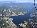
Aerial view of the lake, showing density of homes along the shore

