
Boulder Glacier (Washington) facts for kids
Quick facts for kids Boulder Glacier |
|
|---|---|

Boulder Glacier on the southeast slope of Mount Baker
|
|

Boulder Glacier
Location in Washington (state)
|
|
| Type | Mountain glacier |
| Coordinates | 48°46′04″N 121°47′53″W / 48.76778°N 121.79806°W |
| Length | 1.5 mi (2.4 km) |
| Terminus | icefall/talus |
| Status | Retreating |
Boulder Glacier is a large ice river found on the southeast side of Mount Baker. Mount Baker is a big volcano in the Cascade Range mountains of Washington, USA. This glacier is the sixth largest on Mount Baker. It covers an area of about 1.3 square miles (3.4 square kilometers).
The glacier starts high up near the volcano's top. It flows down between two peaks, Grant Peak and Sherman Peak. It reaches down to an elevation of about 5,000 feet (1,500 meters). Boulder Glacier is known for shrinking a lot. Between 1987 and 2008, it melted back about 1,610 feet (490 meters). This left new rock and soil uncovered.
Contents
How Glaciers Change
Glaciers are like slow-moving rivers of ice. They can grow (advance) or shrink (retreat) over time. This depends on how much snow falls and how warm the weather is.
A History of Retreat and Advance
From 1850 to 1950, Boulder Glacier melted back a huge distance. It retreated about 8,700 feet (2,650 meters). But then, in 1953, a scientist named William Long noticed something different. The glacier started to grow again. This happened because the weather became cooler and wetter.
By 1979, the glacier had advanced (moved forward) about 2,438 feet (743 meters). The end of the glacier in 1979 is where a small stream now flows into Boulder Creek.
Recent Changes to the Glacier
Observations in 2005 showed that the lowest part of the glacier was not moving. This part is about 1,000 feet (300 meters) long. It is likely to melt away completely. This section looks gray because it is covered in rocks and dirt. It also has very few cracks, called crevasses.

As the glacier has melted, it has revealed new features. On the west side of Boulder Creek, there is a small waterfall. This waterfall was hidden by the glacier until recently.
Exploring Boulder Glacier
You can get close to Boulder Glacier by hiking the Boulder Ridge Trail. This trail is number 605.
The Trail Through the Forest
The trail goes through a beautiful forest. Here you can see many different kinds of trees, like pacific silver firs. There are also many standing dead trees, called snags. In the fall, you might see many types of mushrooms growing.
Reaching the Ridge
Around 4,300 feet (1,300 meters) high, the trail climbs onto a side ridge. This ridge was formed by the glacier long ago. At about 4,600 feet (1,400 meters), you will climb over some rocks. This part is not too hard, like climbing a short ladder. Then you go through a steep forest for about 120 feet (37 meters). After this, you reach the top of the ridge, and the trail disappears.
Views from Boulder Ridge
Boulder Ridge offers amazing views. It has open, grassy areas covered in heather plants. You can also see several other ridges left behind by glaciers that have melted. The very top of the ridge is rocky and unstable. Rocks can fall from the end of the glacier above, so visitors need to be careful.
Climbing Mount Baker
Boulder Glacier is one of the popular ways to climb Mount Baker. The first time someone climbed this route was on August 24, 1891.
The Climbing Route
Climbers often use a path that goes between Boulder Glacier and Park Glacier. This helps them avoid parts of the glacier that have many deep cracks (crevasses). At about 10,000 feet (3,000 meters) high, the route goes around some steep rocks and ice. Finally, climbers reach the summit ridge, just east of Grant Peak.
Gallery
-
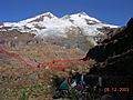
Boulder Glacier in 2003 with its 1985 terminus in red
-
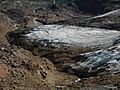
View of 2004 terminus from above
-

View from Boulder Ridge


