Lewis River (Washington) facts for kids
Quick facts for kids Lewis River |
|
|---|---|

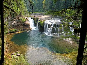
Lower Falls of the Lewis River
|
|
|
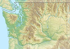
Location of the mouth of the Lewis River in Washington
|
|
| Country | United States |
| State | Washington |
| County | Skamania, Clark, and Cowlitz |
| Physical characteristics | |
| Main source | Mount Adams Cascade Range, Skamania County, Washington 7,194 ft (2,193 m) 46°13′28″N 121°31′44″W / 46.22444°N 121.52889°W |
| River mouth | Columbia River opposite St. Helens, Oregon, and on the border between Cowlitz and Clark counties, Washington 10 ft (3.0 m) 45°51′04″N 122°46′49″W / 45.85111°N 122.78028°W |
| Length | 95 mi (153 km) |
| Basin features | |
| Basin size | 1,046 sq mi (2,710 km2) |
The Lewis River is a river in southwestern Washington, United States. It flows into the Columbia River. The Lewis River is about 95 miles (153 km) long. It helps drain the Cascade Range mountains north of the Columbia River.
The area that the river drains, called its drainage basin, covers about 1,046 square miles (2,709 km2). The river's average yearly water flow is about 6,125 cubic feet per second (173.4 m3/s). The Lewis River is named after A. Lee Lewis, an early settler. It is not named after Meriwether Lewis of the famous Lewis and Clark Expedition.
Contents
River History
Early Inhabitants
Long ago, Native American tribes lived along the Lewis River. Sadly, in the 1830s, many Native people got very sick from diseases brought by early settlers. This caused a big drop in their population.
Because of this, tribal groups often changed. For example, a village about 5 miles (8.0 km) from the river's mouth was first home to the Cowlitz. After 1830, Klickitat people lived there.
When the Lewis and Clark Expedition explored the area, they met a tribe they called "Cathlapotles." These were likely Chinook people. They also noted a village near the river's mouth where Sahaptin-speaking people, probably Klickitat, lived.
Naming the River
The first non-Native person to see the Lewis River was William Robert Broughton in 1792. He was exploring the Columbia River and named it Rushleigh's River.
Later, when Lewis and Clark crossed the river, they called it the Cathlapoote. They had already named another river, the Snake River, "Lewis." Other old names for the river include Kattlepoutal and Washington River.
In 1845, a man named Adolphus Lee Lewis settled near what is now Woodland. He had worked for the Hudson's Bay Company. In 1856, Lewis became the county surveyor and gave his own name to the river.
River Course
The Lewis River starts high up on the west side of Mount Adams. This is in the Cascade Range in northeastern Skamania County. It's about 75 miles (121 km) northeast of Portland, Oregon.
The river flows southwest through the Gifford Pinchot National Forest. It passes south of Mount St. Helens. The Lewis River forms the border between Cowlitz County to the north and Clark County to the south.
Towns along the river include Cougar, Ariel, and Woodland. For its last 10 miles (16 km), the river turns south, then west. It then flows into the Columbia River from the east. This is across from St. Helens, Oregon, about 15 miles (24 km) north of Vancouver, Washington.
East Fork Lewis River
Near where it meets the Columbia River, the main Lewis River (sometimes called the North Fork Lewis River) is joined by the East Fork Lewis River. The main river separates Clark and Cowlitz counties. The East Fork flows through Clark County.
The East Fork starts on the western side of Lookout Mountain in Skamania County. Parks along the East Fork include Moulton Falls, Lucia Falls, Lewisville, and Paradise Point. Sometimes, the East Fork is also called the South Fork Lewis River.
River Changes
Dams and Lakes
The North Fork of the Lewis River has several dams. These dams help create electricity (called hydroelectricity) and control floods.
- Swift Dam creates Swift Reservoir.
- Yale Dam creates Yale Lake.
- Merwin Dam creates Lake Merwin.
Horseshoe Lake
Horseshoe Lake in Woodland used to be a bend in the North Fork of the river. In 1940, a highway was built. This led to a dike being built that straightened the river. This change made Horseshoe Lake separate from the main river.
 | Jessica Watkins |
 | Robert Henry Lawrence Jr. |
 | Mae Jemison |
 | Sian Proctor |
 | Guion Bluford |


