East Fork Lewis River facts for kids
Quick facts for kids East Fork Lewis River |
|
|---|---|

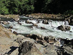
The East Fork Lewis River at Moulton Falls Park
|
|
|
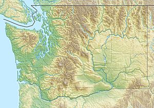
Location of the mouth of the Lewis River in Washington
|
|
| Native name | Yahkohtl |
| Etymology | A. Lee Lewis, early settler |
| Country | United States |
| State | Washington |
| County | Skamania and Clark |
| Physical characteristics | |
| Main source | Green Lookout Mountain Skamania County 4,442 ft (1,354 m) 45°50′33″N 122°05′56″W / 45.84250°N 122.09889°W |
| River mouth | Lewis River Ridgefield, Washington 10 ft (3.0 m) 45°51′57″N 122°43′08″W / 45.86583°N 122.71889°W |
| Length | 43.5 mi (70.0 km) |
| Basin features | |
| Basin size | 150,635 acres |
| Waterfalls | Sunset Falls, Moulton Falls, Lucia Falls |
The East Fork Lewis River is a cool river in Washington State, United States. It's the biggest stream that flows into the Lewis River. This river starts high up on Green Lookout Mountain in Skamania County. It then travels west through Clark County before joining the main Lewis River, not far from the big Columbia River.
Contents
What is the History of the East Fork Lewis River?
Early Explorers and Native People
In 1853, a man named George B. McClellan explored the Yacolt area. He was part of the Northern Pacific Railroad Survey. In his notes, he wrote about visiting the East Fork Lewis River.
McClellan saw Klickitat families camping by a waterfall. They called the river "Yahkohtl." He described them as "plateau-style Indians" who rode horses. They were catching trout from the river. McClellan also thought the waterfalls could be used to make power.
How Did the River Get Its Name?
Many places in this area are named "Lewis" after Meriwether Lewis. He was famous for exploring with William Clark. However, the Lewis River and its East Fork are different. They were named after Adolphus Lewis. He was an early settler in the area. He used to work for the Hudson's Bay Company.
Mills and Waterfalls
After a big fire in 1902 called the Yacolt Burn, many mills were built along the East Fork. These mills helped to cut down and use the trees that were partly burned. Once all the useful timber was gone, the mills were taken apart.
Two waterfalls on the river, Moulton Falls and Lucia Falls, are named after the people who owned these mills. The mills used the power of the waterfalls to operate.
Where Does the East Fork Lewis River Flow?
The East Fork Lewis River starts on the west side of Green Lookout Mountain. This is in the southwest part of the Gifford Pinchot National Forest. It's located in Skamania County.
From there, the river mostly flows west. Most of its path is through Clark County.
Waterfalls and Parks Along the River
The first big feature you'll see is Sunset Falls. Then, the river meets Yacolt Creek at Moulton Falls Regional Park. This park is south of Yacolt. The river then tumbles over Moulton Falls and Lucia Falls.
After that, it flows north of Battle Ground. It passes through Lewisville Park, which is Clark County's oldest park. The river keeps going west through Daybreak Park. It then joins Brazee Creek, just before going through La Center.
Soon after passing La Center, the East Fork curves around Paradise Point. Finally, it joins the main Lewis River.
What is the East Fork Lewis River Watershed?
The East Fork's watershed is a large area of land. It covers about 150,635 acres. A watershed is all the land where water drains into a specific river.
The upper part of the watershed is rocky. It was shaped by erosion, volcanoes, and glaciers. The lower part of the watershed was mostly formed by the river itself. Here, the river flows through flat areas. It often shifts its path and splits into smaller streams. This happens because of moving sand and dirt.
The upper watershed has a lot of hard volcanic ash and other volcanic materials. Because these materials are brittle and the river flows steeply, there's a lot of erosion. This erosion adds to the sand and dirt that builds up downstream.
How Has the River Been Changed?
Sunset Falls used to be a natural barrier for fish. Fish like salmon and steelhead could not swim past it to lay their eggs. In 1982, the falls were changed. Their height was lowered from 13.5 ft (4.1 m) to 8 ft (2.4 m). This change helped more fish. Now, about 12% of the steelhead can swim upstream past the falls to spawn.
What Wildlife Lives in the East Fork Lewis River?
Many kinds of trout and salmon live and lay their eggs in the East Fork. These include Chinook, coho, chum, and steelhead.
In 2014, the East Fork was named a wild steelhead gene bank. This was done by the Washington State Department of Fish and Wildlife. A gene bank helps protect the unique genetic makeup of these fish.
 | Jackie Robinson |
 | Jack Johnson |
 | Althea Gibson |
 | Arthur Ashe |
 | Muhammad Ali |


