Mazama Glacier (Mount Adams) facts for kids
Quick facts for kids Mazama Glacier |
|
|---|---|

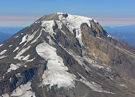
Mazama Glacier at lower center of image
|
|
| Type | Mountain glacier |
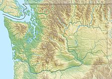
| Coordinates | 46°10′49″N 121°28′12″W / 46.18028°N 121.47000°W |
| Area | 1.40 km2 (0.54 sq mi) in 2006 |
| Length | 1.10 mi (1.77 km) |
| Terminus | Talus |
| Status | Retreating |
Mazama Glacier is a large river of ice found on the southeast side of Mount Adams. Mount Adams is a huge, cone-shaped stratovolcano in the state of Washington, USA. This glacier is located within the Yakama Indian Reservation.
Discovering Mazama Glacier
Mazama Glacier is a type of glacier known as a mountain glacier. It flows down the slopes of Mount Adams. The top of the glacier starts very high up, around 10,800 ft (3,300 m) (about 3,292 meters). Its end, called the terminus, reaches down to about 7,600 ft (2,300 m) (about 2,316 meters). The terminus is where the ice melts or breaks off.
How Mazama Glacier Has Changed
For more than 100 years, Mazama Glacier has been getting smaller. This process is called "retreating." Between 1904 and 2006, the glacier lost almost half of its surface area. It shrank by 46 percent during that time. This means the glacier is melting faster than new snow and ice can build up.
How the Glacier Got its Name
The glacier was not always called Mazama Glacier. It was first known as Hell-roaring Glacier. In 1895, a group of explorers from a club called the Mazamas visited the area. They were on their second yearly trip. During their visit, they decided to change the glacier's name to Mazama Glacier, after their club.
 | John T. Biggers |
 | Thomas Blackshear |
 | Mark Bradford |
 | Beverly Buchanan |


