Mount Meager facts for kids
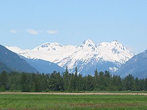
Mount Meager is a volcano in British Columbia, Canada. It is considered an active volcano, meaning it could erupt again. It sits about 150 kilometers north of Vancouver. The top of Mount Meager is mostly covered by snow and glaciers.
This mountain is part of the Garibaldi Volcanic Belt. It is also the most northern volcano in the Cascade Volcanic Arc, which stretches all the way down to northern California. The rocks that make up Mount Meager are mostly lava that is nearly a million years old. In some places, this lava is over 1 kilometer thick!
Mount Meager is part of the Pacific Ranges mountains. It stands tall at 2,680 meters (8,793 feet). Long ago, it was known by another name: Cathedral Mountain.
Mount Meager's Past Eruptions
Mount Meager is famous for its last major eruption, which happened about 2,350 years ago. This eruption was quite unusual. It sent a huge amount of rock and ash from the northeast side of the volcano. This debris blocked a big river called the Lillooet River.
The river was dammed, meaning a natural wall was formed, holding back the water. This wall was at least 100 meters high, creating a large lake. The lake grew to a maximum height of 810 meters and was at least 50 meters deep!
Over time, the water in the lake started to wear away the rock and ash dam. This process created a waterfall known as Keyhole Falls. When the water finally broke through the dam, there was a massive flood. This flood carried huge blocks of rock, some as big as small houses! During this eruption, ash was thrown more than 20 kilometers into the sky. The wind carried this ash eastward, reaching as far as Alberta.
Understanding Volcanic Dangers
Mount Meager is an unstable volcano. This means its slopes are not very strong. Over the last 7,300 years, it has sent large amounts of clay and rock into the Pemberton Valley at least three times. These events are called debris flows or landslides.
Two earlier debris flows, around 4,450 and 7,300 years ago, sent rock and mud at least 32 kilometers away from the volcano. More recently, Mount Meager has caused smaller landslides about every ten years. One such landslide in 1975 sadly killed four geologists near Meager Creek.
People who work or visit the nearby areas are at risk. Activities like logging, mining, tourism, and outdoor recreation happen on the slopes and in the valleys around the volcano. These areas are vulnerable to the volcano's active land movements.
Scientists estimate that there is a chance of Mount Meager covering parts of the Pemberton Valley with a debris flow about once every 2,400 years. These past events did not involve volcanic eruptions. However, scientists warn that the volcano could release another huge debris flow over populated areas at any time without warning.
The way Mount Meager has erupted in the past shows it can be very explosive. This means it could also pose a danger to communities far away. Towns across southern British Columbia and Alberta could be affected. The town of Pemberton, British Columbia, which is about 50 kilometers away, faces a local risk.
Another explosive eruption at Mount Meager would also greatly affect local mining and logging businesses. It would also have a big negative impact on the fishing industry in the Lillooet River.
 | Calvin Brent |
 | Walter T. Bailey |
 | Martha Cassell Thompson |
 | Alberta Jeannette Cassell |


