Mount Bute facts for kids
Quick facts for kids Mount Bute |
|
|---|---|

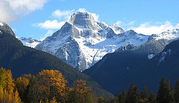
Mount Bute with the west face featured
|
|
| Highest point | |
| Elevation | 2,810 m (9,220 ft) |
| Prominence | 640 m (2,100 ft) |
| Isolation | 12.1 km (7.5 mi) |
| Parent peak | Mount Grenville (3126 m) |
| Listing | Mountains of British Columbia |
| Geography | |
| Location | British Columbia, Canada |
| Parent range | Coast Mountains |
| Topo map | NTS 92K15 |
| Type of rock | granite |
Mount Bute, also called Bute Mountain, is a tall mountain in British Columbia, Canada. It stands at about 2,810-metre (9,220-foot) high. This impressive peak is part of the Coast Mountains.
Mount Bute is known for its amazing 800-meter (about half a mile) tall west face. This side of the mountain is made of sheer granite rock. The Bute Glacier covers the northern part of the mountain. You can see Mount Bute from Waddington Harbour, which is at the end of Bute Inlet. This area is very wild and not many people visit it.
The closest higher mountain is Mount Grenville, which is about 13.0 km (8.1 mi) to the east-northeast. Mount Grenville is the highest point in the icefield. Mount Bute is also about 63.0 km (39.1 mi) southeast of Mount Waddington. Mount Waddington is the tallest peak in the entire Coast Mountains range.
What's the History of Mount Bute?
Mount Bute, like the nearby Bute Inlet, got its name a long time ago. In 1792, a famous explorer named Captain George Vancouver named it. He chose the name to honor John Stuart, 3rd Earl of Bute. Earl of Bute was a very important person in Great Britain. He served as the Prime Minister from 1762 to 1763.
One of John Stuart's grandsons, Charles Stuart, was also on Captain Vancouver's ship, the Discovery. The name "Mount Bute" was officially accepted in 1963 by the Geographical Names Board of Canada.
What is the Climate Like at Mount Bute?
Mount Bute is in a marine west coast climate zone. This type of climate is found in western North America. It means the weather is often mild and wet.
Most of the weather systems, like storms, start over the Pacific Ocean. They then travel east towards the Coast Mountains. When these weather systems hit the mountains, they are forced to rise. This process is called Orographic lift. As the air rises, it cools down and drops its moisture. This means the Coast Mountains get a lot of rain or snow.
The area gets a lot of precipitation, especially in winter. Temperatures can drop very low, sometimes below −20 °C. With wind, it can feel even colder, below −30 °C. The water from melting snow and rain on Mount Bute flows into the Southgate River. This river then empties into Bute Inlet. However, the meltwater from the Bute Glacier flows into Galleon Creek.
Can You Climb Mount Bute?
Mount Bute is a challenging climb, especially its steep west face. The first people to successfully climb this impressive west face were Greg Foweraker and Don Serl in 1986. Just three days later, another team made the second climb. This team included famous climber Fred Beckey, Kit Lewis, and Jim Nelson.
A very difficult climbing route on the mountain is called School of Rock. This route has 50 different sections, or "pitches." It was first climbed in 2009 by Jimmy Martinello, Bruce Kay, and Jason Sinnes.
 | Delilah Pierce |
 | Gordon Parks |
 | Augusta Savage |
 | Charles Ethan Porter |


