
Hatzic Valley facts for kids

The Hatzic Valley is a beautiful lowland area in the southern part of the Fraser Valley Regional District in British Columbia, Canada. It's part of what's called the Lower Mainland. This valley was formed a long, long time ago by huge sheets of ice, called glaciers, moving south. It's like a long, low ditch carved by ice, stretching from Stave Lake all the way to the Fraser River.
The Hatzic Valley officially covers the area from the southeast end of Stave Lake in the northwest down to Hatzic Lake in the south. On its eastern side, the valley is bordered by the Douglas Ranges, with a ridge called Durieu Ridge closest to the valley. The southern tip of this ridge is Dewdney Peak.
The valley includes Davis Lake Provincial Park and Mount St. Benedict in the north. It also has Cascade Falls Regional Park in the northeast. The Hatzic Valley is about 12.5 kilometers (about 7.8 miles) long, from Davis Lake to Hatzic Lake. It's about 2.5 kilometers (about 1.5 miles) wide at Durieu. Around 1,300 people call this valley home.
Inside Hatzic Valley, there are several small communities that aren't officially towns. These include Hatzic Island and Hatzic Prairie in the south. The community of Durieu is in the middle. And McConnell Creek is in the north. You might see "Miracle Valley" on some maps, but that was actually a private property, not a community.
Contents
Communities in Hatzic Valley
McConnell Creek Area

McConnell Creek is the northern part of Hatzic Valley, located north of Durieu Road. A specific piece of land here, at 14100 Stave Lake Road, used to be known as "Miracle Valley." McConnell Creek is also the original name for Cascade Creek, which flows from Cascade Falls through this area and into Stave Lake.
The area is named after a logger named Jack McConnell. He worked in the area but actually lived in Silverdale, British Columbia. Most of McConnell Creek is about 100 meters (328 feet) above sea level. The lowest point is Durieu Road, at about 20 meters (65 feet) above sea level. The highest point in McConnell Creek, and in the whole Hatzic Valley, is the top of Mount St. Benedict, which is 1,278 meters (4,193 feet) high.
In the past, McConnell Creek had several sawmills, but they are all closed now. The area got electricity in 1949. That same year, the McConnell Creek Community Hall opened on Hartley Road.
What was Miracle Valley?
Miracle Valley was a private piece of land, about 160 acres (0.65 square kilometers) in size. It was located within the McConnell Creek area. The Salvation Army bought this land in 1963. In 2010, it was sold and became Khalsa Centre. This is a cultural retreat and campground that also has a blueberry farm. So, "Miracle Valley" as a place name hasn't existed since 2010.
Hatzic Prairie and Durieu

Hatzic Prairie is the southern part of Hatzic Valley, located south of Durieu Road.
Long ago, the Kwantlen First Nation (part of the Sto:lo) used Hatzic Prairie as a summer camping spot. The first European settler recorded was John or James Kelly in the 1860s. He was an Irish squatter who used to drive wagons in the Cariboo. He was sent away after illegally bringing in cattle.
In the 1880s, the Burton family owned about 1,200 acres of land here. It was called "Burton Prairie." The name changed around 1889 after Ralph Burton sold his land because of flooding from the Fraser River. One of the new owners, Livingston Thompson, built a post office. It opened on April 1st of that year. He became the first postmaster and renamed the land Hatzic Prairie.

The post office's name changed again on March 1, 1910, to Durieu. This was to honor Archbishop Pierre-Paul Durieu, who had passed away about ten years earlier. This new name, Durieu, became official with the British Columbia government in 1939. Even though the post office closed in 1942, the name Durieu stayed. It even became known as a "community" because it had enough people and a central area with a hall.
Flooding in Hatzic Prairie
Hatzic Prairie got its name because of flooding from the Fraser River. The area continued to flood, especially in 1894. The biggest flood recorded was the "Great Flood" of 1948. This flood covered over 13,000 acres of land in nearby low areas. Twelve square miles of that was on Hatzic Prairie.
Because of these past flooding problems, many studies have been done. These studies look at how floods could affect communities in the lower Fraser Valley, especially Hatzic Prairie. Much of Hatzic Prairie is lower than 20 meters (65 feet) above sea level. Water drains from this area through Legace Creek.
One study in 1992, called the "Hatzic Prairie Drainage Study," aimed to create a plan to reduce flood damage. Another report in 2005, the "Flood Damage Recovery Plan, Legace Creek," suggested removing gravel and reshaping the creek. This would help prevent the creek from overflowing and damaging properties. However, the report also warned that strong floods could still bring a lot of mud and rocks into the creek.
More recently, the Fraser Basin Council started a big project called the Lower Mainland Flood Management Strategy (LMFMS). The first part of this project, finished in 2016, looked at flood risks and existing flood protection in the region. Maps from this study showed that Hatzic Lake's north and east sides could see floodwaters rise three meters (almost 10 feet) or more. The second part of the LMFMS program is working on a long-term plan for flood management.
Water Resources
There are three main underground water sources, called aquifers, in the Hatzic Valley area:
- The Hatzic Prairie Aquifer is the furthest south and closest to the surface.
- The Cascade Aquifer is the furthest north, between Cascade and Davis Creeks.
- The McConnell Aquifer (sometimes called the "Miracle Valley Aquifer") is in between the other two.
The Hatzic Prairie and Cascade aquifers are considered "highly vulnerable." This means they can easily get polluted because the soil above them lets water through quickly. The McConnell Aquifer is "low vulnerability." This is because it's covered by layers of soil that don't let water through easily, which helps protect it from pollution. However, some experts say this aquifer might not refill with water as quickly as the others.
Many people in Hatzic Valley get their water from wells connected to these aquifers. The Fraser Valley Regional District (FVRD) also supplies water south of Durieu Road using wells, pumps, and pipes. Water quality in Hatzic Prairie is a concern. This is because the underground water level is often high, and there's a risk of pollution from farms and septic systems, especially since the aquifer is vulnerable.
The FVRD is looking into expanding its water supply system. Many studies have been done on how to keep the water supply sustainable. As of March 2019, the FVRD planned to start building another well. This was to make sure they didn't lose a special grant for clean water.
Land Use in Hatzic Valley
Parks and Protected Areas
Hatzic Valley is next to Hatzic Lake in the south and Stave Lake in the northwest. However, you can't get directly to Stave Lake from Hatzic Valley. The valley is connected to Cascade Falls Regional Park in the northeast and Davis Lake Provincial Park in the north.
Private Land Use
Most of the private land in Hatzic Valley is part of the British Columbia Agricultural Land Reserve. This means the land is mainly used for farming, both for hobbies and for commercial businesses. People also live on this land. Natural resources like timber (wood) and gravel are also taken from the nearby hills and mountains.
Images for kids
-
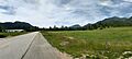
Looking north over Hatzic Valley from Sylvester Road. You can see light snow on Mount Robie Reid.
-
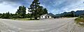
The McConnell Creek Community Hall with Mount St. Benedict behind it.
-
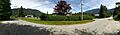
Looking north across Durieu Road.
-
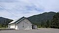
Looking west over the Hatzic Prairie Community Hall.
