
E. C. Manning Provincial Park facts for kids
Quick facts for kids E.C. Manning Provincial Park |
|
|---|---|
|
IUCN Category II (National Park)
|
|

Hiking the sub-alpine meadows in Manning Park.
|
|
_location_map.svg)
E.C. Manning Provincial Park
Location in British Columbia
|
|
| Location | British Columbia, Canada |
| Nearest town | Hope, British Columbia and Princeton, British Columbia |
| Area | 83,671 ha (206,760 acres) |
| Established | 1941 |
| Visitors | 1.091 million (in 2017-18) |
| Governing body | BC Parks |
E.C. Manning Provincial Park is a large and beautiful provincial park in British Columbia, Canada. Most people call it Manning Park. It's also home to a resort and ski area. The park covers a huge area of 83,671 hectares (about 323 square miles). In 2017-18, it was the second most visited provincial park in British Columbia. You can find the park along British Columbia Highway 3, stretching between the towns of Hope and Princeton, right near the Canada-United States border.
Contents
Park History
People have used the land in Manning Park for a very long time. The first people to live here were the native peoples of British Columbia. They traveled through the area using routes that are now part of the Skyline Trail. The first European explorer arrived in 1813, and the area was mapped in 1827.
Before the 1930s, it was very hard to reach this area. There were no good roads or trails over the mountains. In 1931, a small part of the park was first set aside. It was called the Three Brothers Mountain Reserve. This was done to stop too many animals from eating all the plants. Later, in 1936, it became a game reserve for animals. Finally, in 1941, the park was officially formed as Three Brothers Mountain Park.
Building a road through the park started in 1929 as a project to help people find work. However, it wasn't finished then. During World War II, Japanese Canadians were forced to move to camps. One camp was in Sunshine Valley, near the park. Workers from this camp helped build the current Hope-Princeton highway. This important road was completed in 1949.
The park was named after Ernest Callaway Manning. He was the Chief Forester for British Columbia from 1936 to 1941. Sadly, he died in a plane accident in 1941. Manning was very important in creating the idea of setting aside land for future generations to enjoy. He worked with Arthur Wellesley Gray to establish several parks, including E.C. Manning Provincial Park. Over the years, the park's size has changed a bit.
Park Geography
Manning Park has many different types of landscapes. You can find wet coastal rain forests and tall, snow-covered mountains. There are also beautiful alpine meadows full of colorful wildflowers. The park also has a chain of small lakes and wide riverbeds in the valleys.
Many trails cross the park. Some of these trails follow old routes used by fur traders and native hunters. The park is famous for its amazing display of subalpine flowers in midsummer. Another special plant is the Rhododendron. At Rhododendron Flats, near the park's western entrance, you can see many pinkish-red rhododendrons. They are a protected plant and bloom in early to mid-June.
Manning Park Resort
Inside the park, there is a resort called Manning Park Resort. It can host almost a thousand people. The resort manages the hotel buildings, restaurants, cabins, and campgrounds. They do this under a contract with the British Columbia Government.
The resort first opened in the late 1950s, after the Hope-Princeton Highway was built. At first, the area was just for day visitors, with a restaurant and gas station. But it quickly grew bigger. The park became very popular, so it was made easy for everyone to visit.
In the 1960s, the province started ski operations in Manning Park. They used different types of rope-tows. Later, in 1967 and 1970, the Blue and Orange chairlifts opened. The ski hill has been open every year from December to March since the early 1960s. Today, the resort runs the Gibson Pass Ski Area. In 1986, the resort became privately owned, instead of being run by the government.
In 2009, the resort had financial problems and almost closed in 2013. But then, the operator of Sunshine Valley RV Resort bought it. The resort and ski hill are now fully open again. In 2019, the Orange Chairlift was replaced with a new one called the Bear Chair. The resort has also added new rental cabins to welcome more visitors.
Park Recreation
Manning Park offers many ways to have fun outdoors. There are lots of walking and hiking trails. Some are short 15-minute walks, while others are long hikes that take 5 or 6 days.
Lightning Lake is a popular spot for water activities. You can go canoeing, kayaking, and fishing there. You can rent canoes, rowboats, kayaks, and stand-up paddle boards at the lake. The best time to go boating in the summer is in the morning before the winds pick up.
The park has many campgrounds. One of them is special because it's open all year round. It also offers full hookups for RVs.
Manning Park is the northern end of the famous Pacific Crest Trail. This long hiking trail goes all the way to Mexico. The park is also crossed by the Hope Pass and Dewdney Trail. Another trail, the Centennial Trail, was built in 1966 to celebrate Canada's 100th birthday.
Park Location
Manning Park stretches for about 58 kilometers (36 miles) from one end to the other. The western entrance is about 26 kilometers (16 miles) east of Hope, British Columbia. The eastern entrance is about 52 kilometers (32 miles) west of Princeton, British Columbia. The main part of the park is about 68 kilometers (42 miles) from both Hope and Princeton. It's also less than 5 kilometers (3 miles) from the US border.
Park Wildlife
Manning Park is home to a huge variety of animals. Over 200 different kinds of birds have been seen here. There are also many mammals, including black bears, Mule Deer, Hoary Marmot, Yellow-bellied Marmot, and Columbian ground squirrels.
You can also find many amphibians and reptiles in the park. These include the Coastal Tailed Frog, Columbia Spotted Frog, Western Toad, Pacific Treefrog, and Long-toed Salamander. There are also all three types of Gartersnake and Alligator Lizard. The park also works to protect less common animals like the mountain beaver and the wolverine.
Major Rivers
Several important rivers start in the passes and meadows within Manning Park.
The Skagit River begins on the west side of Allison Pass. It flows northwest along Highway 3. Then it meets the Sumallo River and turns southwest, leaving the park. The Sumallo River also flows through the park, entering near the West Gate.
The small Skaist River also has its lower parts within the park. It flows into the Skagit River across the valley from Silverdaisy Mountain.
The Similkameen River is the largest river that flows into the Okanagan River. It starts in the northern part of the park. It flows southeast and then northeast through the park, following Highway 3 closely. It leaves the park at the East Gate.
Images for kids
-
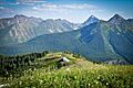
Hozameen Range from Snow Camp Mountain in E.C. Manning Provincial Park
-
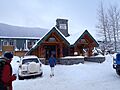
The main lodge building at Manning Park Resort
-
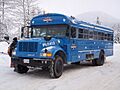
The free shuttle between the ski hill and the hotel, sporting the logo of Manning Park Resort as used until 2019.
-
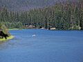
Lightning Lake with a canoe in the distance.
-

Mountain panorama


