Oroville, Washington facts for kids
Quick facts for kids
Oroville
|
||
|---|---|---|

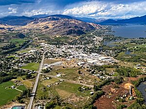
View of Oroville, Washington and Osoyoos Lake, looking north towards Canada.
|
||
|
||

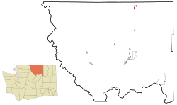
Location of Oroville in
Okanogan County, Washington |
||
| Country | United States | |
| State | Washington | |
| County | Okanogan | |
| Established | January 1, 1892 | |
| Incorporated | August 7, 1908 | |
| Government | ||
| • Type | Mayor–council | |
| Area | ||
| • Total | 1.85 sq mi (4.78 km2) | |
| • Land | 1.69 sq mi (4.38 km2) | |
| • Water | 0.16 sq mi (0.40 km2) | |
| Elevation | 938 ft (286 m) | |
| Population
(2020)
|
||
| • Total | 1,795 | |
| • Density | 970.3/sq mi (375.5/km2) | |
| Time zone | UTC-8 (PST) | |
| • Summer (DST) | UTC-7 (PDT) | |
| ZIP codes |
98844
|
|
| Area code(s) | 509 | |
| FIPS code | 53-51970 | |
| GNIS feature ID | 1524077 | |
| Website | City of Oroville | |
Oroville is a city in north-central Washington, United States. It's located in the northern part of the Okanogan Highlands. Oroville is part of Okanogan County. It sits between the cities of Omak and Penticton. In 2020, about 1,795 people lived there.
Contents
History of Oroville
Oroville was first settled by European people in the late 1850s. It was known as 'rag town' back then. In 1892, the settlement was named Oro, which is the Spanish word for gold. This name was chosen because of the gold mines nearby. They hoped it would attract more people looking for gold and setting up businesses.
The Post Office didn't like the name "Oro." This was because another town in Washington was already called "Oso." So, in 1909, the name was changed to Oroville.
Railways and Travel
Oroville was an important stop on the Spokane Falls and Northern Railway line. This railway connected British Columbia to Spokane. Later, in 1914, a new railway branch was built south to Wenatchee. This new path helped trains avoid steep hills on the original Spokane track.
Passenger trains, run by the Great Northern Railway, stopped serving Oroville in 1953. However, freight trains continued to use the line.
Modern Oroville
In the mid-2000s, Oroville started to become a popular place for tourists. New vacation homes were planned and built. The city's economy has faced some challenges since 2008.
Oroville is also home to the Dorothy Scott Airport. This is an international airport where you can clear U.S. Customs. It opened in August 1937 and is located just two miles outside the town center.
Geography of Oroville
Oroville is located about 4 miles (6.4 km) south of the Canada–United States border. There's an official crossing point into Osoyoos, British Columbia from Oroville.
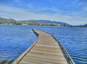
The city is at the south end of Osoyoos Lake. This lake flows into the Okanogan River on the east side of town. To the west, the town is bordered by the Similkameen River. U.S. Route 97, a major highway, also runs through Oroville.
The United States Census Bureau says that Oroville covers about 1.68 square miles (4.35 square kilometers). Most of this area is land, with a small part being water.
Climate in Oroville
Oroville has a climate with big changes in temperature throughout the year. Summers are warm to hot, and winters are moderately cold. This type of weather is common in places with a humid continental climate.
Economy in Oroville
The main part of Oroville's economy comes from agriculture. There are many fruit orchards and some grape vineyards around the town.
In the past, when Oroville was a busy mining town, it had many places to eat, shops, and even a drive-in movie theater. Today, the town's economy is still supported by farming.
Local Businesses and Transport
Oroville has a weekly newspaper called the Okanogan Valley Gazette-Tribune. It started in 1905 as the Oroville Weekly Gazette. There's also a monthly magazine called Okanogan Living that covers the area.
The city is the northern end point for the Cascade and Columbia River Railroad. This is a short railway line owned by a company called Genesee & Wyoming.
Population of Oroville
| Historical population | |||
|---|---|---|---|
| Census | Pop. | %± | |
| 1910 | 495 | — | |
| 1920 | 1,013 | 104.6% | |
| 1930 | 800 | −21.0% | |
| 1940 | 1,206 | 50.8% | |
| 1950 | 1,500 | 24.4% | |
| 1960 | 1,437 | −4.2% | |
| 1970 | 1,555 | 8.2% | |
| 1980 | 1,483 | −4.6% | |
| 1990 | 1,505 | 1.5% | |
| 2000 | 1,653 | 9.8% | |
| 2010 | 1,686 | 2.0% | |
| 2020 | 1,795 | 6.5% | |
| U.S. Decennial Census 2020 Census |
|||
2010 Census Information
According to the 2010 census, there were 1,686 people living in Oroville. These people lived in 698 households, and 434 of these were families. The city had about 1,028 people per square mile (397 per square kilometer).
The average household had about 2.41 people, and the average family had about 3.03 people. The median age in the city was 39.4 years old. About 26.2% of the residents were under 18 years old.
See also
 In Spanish: Oroville (Washington) para niños
 | Stephanie Wilson |
 | Charles Bolden |
 | Ronald McNair |
 | Frederick D. Gregory |


