Okanogan River facts for kids
Quick facts for kids Okanogan River |
|
|---|---|
 |
|

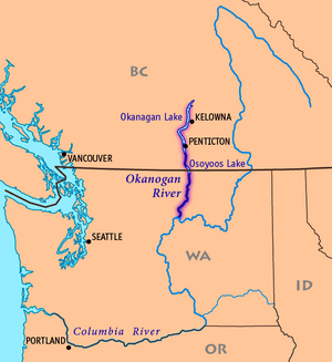
Map of the Okanogan River, tributary of the Columbia River
|
|
| Other name(s) | Okanagan River |
| Countries | United States Canada |
| State | Washington |
| Province | British Columbia |
| Cities | Penticton, BC, Omak, WA |
| Physical characteristics | |
| Main source | Okanagan Lake Penticton, British Columbia, Canada 1,122 ft (342 m) 49°30′13″N 119°36′42″W / 49.50361°N 119.61167°W |
| River mouth | Columbia River Brewster, Washington, United States 781 ft (238 m) 48°5′54″N 119°44′3″W / 48.09833°N 119.73417°W |
| Length | 115 mi (185 km) |
| Basin features | |
| Basin size | 8,200 sq mi (21,000 km2) |
| Tributaries |
|
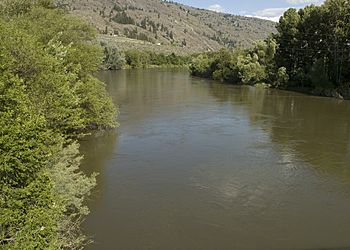
The Okanogan River is a cool waterway that flows through parts of Canada and the United States. In Canada, it's called the Okanagan River. It's about 115 miles (185 km) long and is a branch of the mighty Columbia River.
This river helps drain a beautiful plateau area. This area is known as the Okanagan Country. It's located east of the Cascade Range mountains. The Canadian part of the river has been changed by engineers since the 1950s. They made its path more like a channel.
Contents
River's Journey and Path
The Okanogan River starts in southern British Columbia, Canada. It flows out of the southern end of Okanagan Lake. This lake is just north of the city of Penticton.
Flowing South
The river then flows south past Penticton. It goes through Skaha Lake and past Okanagan Falls. Next, it travels through Vaseux Lake and past Oliver. Finally, it reaches Osoyoos and Osoyoos Lake.
Crossing the Border
Osoyoos Lake crosses the Canada–United States border. The Okanogan River flows out of this lake at Oroville. This town is on the southern shore of the lake. It is in Okanogan County. When the river crosses the border, its name changes spelling. It goes from Okanagan to Okanogan. At this point, the river's average flow is about 643 cubic feet per second.
Journey Through Washington
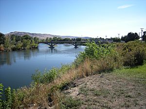
From Oroville, the Okanogan River continues south. It flows through Okanogan County. It passes by the towns of Okanogan and Omak. The river also forms the western edge of the Colville Indian Reservation.
The Okanogan River joins the Columbia River from the north. This meeting point is about 5 miles (8 km) east of Brewster. It's located between two large dams: the Wells Dam (downstream) and the Chief Joseph Dam (upstream). The water behind the Wells Dam forms a reservoir called Lake Pateros. This is where the Okanogan River empties.
River Branches and Streams

The Okanogan River gets water from several smaller rivers and streams. The Similkameen River flows into it from the west near Oroville.
Other Water Sources
- Omak Creek joins the Okanogan River from the east near Omak.
- Tonasket Creek also flows in from the east near Oroville.
- Bonaparte Creek meets the river at Tonasket. This creek comes from Bonaparte Lake. It also gets water from the Aeneas Valley.
- Sometimes, Salmon Creek adds water to the Okanogan near the town of Okanogan. However, much of Salmon Creek's water is used for irrigation during most of the year.
History of the Okanogan River
The name of the river comes from the Okanagan (or Syilx) people. Their word for the place was [ukwnaqín]. Later, the name Okanagan was also used for the Syilx people themselves.
Early Fur Trade
Old maps from the fur trade era called the Okanogan River the "Caledonia River." This was because it was an important route. It connected the Columbia District with the New Caledonia Fur District. This northern fur district started north of Okanagan Lake.
Fort Okanogan was a fur-trading post. It was opened by the Pacific Fur Company (PFC) in late 1811. This fort was located where the Okanogan River meets the Columbia River. The War of 1812 made things difficult for the PFC. They had to sell their property to their Canadian rivals, the North West Company. In 1821, the North West Company joined with the Hudson's Bay Company. The Hudson's Bay Company kept a presence at Fort Okanogan until the 1850s.
Gold Rush Era
During the Fraser Canyon Gold Rush in 1858-1859, many miners traveled along the river. These armed groups often had conflicts with the native people. They used the Okanagan Trail and its western branch, the Similkameen Trail. After the fighting stopped, this route remained important. It was the southern part of the overland trail to the Cariboo Gold Rush. It was also known as the Hudson's Bay Brigade Trail.
See also
 In Spanish: Río Okanagan para niños
 | Madam C. J. Walker |
 | Janet Emerson Bashen |
 | Annie Turnbo Malone |
 | Maggie L. Walker |

