Columbia District facts for kids
Quick facts for kids
Columbia
|
|
|---|---|
|
Fur trading district
|
|

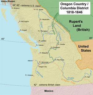
Map of the Oregon Country "jointly occupied" by the United States and the United Kingdom; the Columbia Department at its greatest extent included areas far to the north and to the south.
|
|
| Country | British North America |
The Columbia District was a very important area for the fur trade in the 1800s. It was located in the Pacific Northwest part of British North America. Much of this land was also claimed by the United States, leading to a long dispute.
The North West Company first explored this region between 1793 and 1811. They set up fur trading operations around 1810. Later, in 1821, the North West Company joined with the Hudson's Bay Company. After this, the Columbia District became known as the Columbia Department. The fur trade in this area largely ended with the Oregon Treaty in 1846.
Contents
Exploring the Columbia District's Early Years
The Columbia District began to take shape in the early 1800s.
David Thompson's Explorations
Starting in 1807, an explorer named David Thompson worked for the North West Company (NWC). He explored much of the land that would become the Columbia District. In 1811, he found the Athabasca Pass. This mountain pass became a key route for travel and trade into the new fur district.
American Fur Trading Efforts
An American company called the Pacific Fur Company (PFC) also wanted to be part of the fur trade. They built Fort Astoria near the mouth of the Columbia River. This company was mostly funded by John Jacob Astor, a German-American merchant.
During the War of 1812, the Pacific Northwest was far from the main fighting. Before the war, both American and British companies traded peacefully. But when news of a British warship arrived, the American company faced a problem. In October 1813, the PFC decided to sell its forts and goods to the NWC. A British warship, HMS Racoon, arrived the next month. In honor of King George III of the United Kingdom, Fort Astoria was renamed Fort George.
The North West Company's Role
The North West Company played a big part in shaping the Columbia District.
Organizing the Fur Trade
In 1815, the NWC officially divided its business west of the Rocky Mountains into two areas. The older area was the New Caledonia District to the north. The Columbia District was to the south.
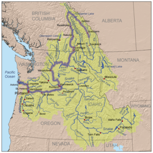
After 1815, New Caledonia started getting most of its yearly supplies by sea. These supplies came up the lower Columbia River. By 1820, the NWC had six trading posts on the lower Columbia River and its smaller rivers. These posts included Fort George (Astoria), Fort Nez Percés, Fort Okanogan, Spokane House, Flathead Post, and Kootanae House.
Boundaries and Joint Occupation
Under the North West Company, the Columbia District had clear boundaries. It was roughly bordered by the southern edge of the Thompson River in the north. Its southern and eastern borders followed the limits of the Columbia River basin. North and west of the Thompson River was the New Caledonia fur district.
The Treaty of 1818 between the U.S. and Britain was important. Both countries agreed that they could freely use the Oregon Country. This "joint occupation" lasted until the Oregon Treaty of 1846. American companies tried to trade in the region but struggled against the Hudson's Bay Company.
Working with Native Peoples
The North West Company found that Native Americans in the Columbia region were often not interested in trapping furs. The company relied on native workers east of the Rocky Mountains. So, in 1815, the NWC began bringing Iroquois people from the Montreal area. The Iroquois were skilled hunters and trappers. This practice continued for many years and was key to expanding the fur trade.
The company hoped the Iroquois would teach local natives how to trap. But this effort mostly failed. Local natives focused on salmon fishing, which was plentiful. This meant they had little reason to trap furs. Sometimes, there were conflicts between the Iroquois and local native groups.
The NWC also started hiring Native Hawaiians, known as Kanakas. The Hudson's Bay Company later greatly expanded this practice.
Trade Routes and Challenges
From 1813 to 1821, the North West Company was the main fur trading power in the region. Each spring, a supply ship would arrive at Fort George (Astoria). Fur brigades from the interior would gather there. Furs were loaded onto the ship, and supplies were taken back inland. The ship would then sail to Canton, China. There, furs were traded for tea and other goods, which were then taken to Britain. This completed a global trade route.
The Columbia District was not very profitable for the North West Company. The most profitable areas were the Kootenay River and Snake River regions. New Caledonia produced many furs, but it was expensive to operate due to its distance.
A key achievement was building Fort Nez Percés on the Columbia River. This fort became a vital spot for getting horses and a base for expeditions. Shipping furs to China was not a financial success for either the NWC or the Hudson's Bay Company. This was partly because the East India Company had a monopoly on British trade in the Far East.
The Hudson's Bay Company Takes Over
In 1821, the North West Company joined with the Hudson's Bay Company (HBC). The fur trade operations west of the Rocky Mountains were reorganized. In 1827, the New Caledonia and Columbia fur districts were combined into the Columbia Department. The name New Caledonia still referred to the northern district.
Fort Vancouver: A New Headquarters
In 1824, the Hudson's Bay Company built Fort Vancouver on the lower Columbia River. This fort became the main headquarters for the entire Columbia Department. Before this, Fort Astoria (Fort George) had been the main base.
The York Factory Express Route
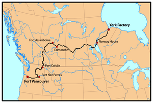
The Hudson's Bay Company used the York Factory Express as an overland route to Fort Vancouver. This route grew from an earlier one used by the North West Company. By 1825, two groups usually traveled this route. They started in spring from opposite ends: Fort Vancouver and York Factory on Hudson Bay. They would pass each other in the middle of the continent.
Each group had about 40 to 75 men and special boats. They traveled very fast for the time. Local Native Americans were often paid to help carry goods around waterfalls. A report from 1839 said the trip took about three months and ten days. This was a quick way to resupply forts and send messages between Fort Vancouver and York Factory.
Supplies arrived at Fort Vancouver and York Factory by ship each year. The furs they traded were sent back on these supply ships. Furs from Fort Vancouver often went to China to be traded for Chinese goods. These goods then went to England. Furs from York Factory were sold in London. The express brigades carried supplies in and furs out by boat, horseback, and as backpacks. They also carried reports from Dr. John McLoughlin, the Chief Factor of the Columbia District. This system continued until 1846.
Expanding and Diversifying Trade
Between 1821 and 1846, the HBC greatly expanded its operations in the Columbia Department. The fur trade reached almost every major river, from the Yukon River in the north to the Colorado River in the south. It also went east to the rivers that feed the Missouri River. The HBC stopped American fur trade competition in many ways. They sometimes overhunted areas to create "fur deserts." They also built forts on the Pacific Northwest coast to get furs before American ships could.
The HBC also started trading other goods. They exported farm products, salmon, lumber, and more. They sold these goods to Russian Alaska, Hawaii, and Mexican California. The HBC opened offices in Sitka, Honolulu, and Yerba Buena (San Francisco) to help with this trade.
Fort Vancouver was the center of the fur trade on the Pacific Coast. Its influence reached from the Rocky Mountains to Hawaii, and from Alaska to California. At its busiest, Fort Vancouver oversaw 34 outposts, 24 ports, six ships, and 600 employees. Many Hawaiian workers were employed, with 119 at Fort Vancouver by 1845. For many settlers, the fort was also the last stop on the Oregon Trail before they found land to settle.
By 1843, the Hudson's Bay Company had many posts in the Columbia Department. These included Fort Vancouver, Fort George (Astoria), Fort Nisqually, Fort Umpqua, Fort Langley, Fort Colville, Fort Okanogan, Fort Kamloops, Fort Alexandria, Flathead Post, Kootanae House, Fort Boise, Fort Hall, Fort Simpson, Fort Taku, Fort McLoughlin, and Fort Stikine.
The End of the Columbia Department
More and more American settlers arrived on the Oregon Trail. This led to the Oregon boundary dispute between the U.S. and Britain. The Oregon Treaty was signed in 1846. This treaty set the U.S.-British border at the 49th parallel. This border split the Columbia Department in half. The lower Columbia River, which was the heart of the system, was now in the U.S. The U.S. soon organized its part as the Oregon Territory.
The main office for fur operations then moved to Fort Victoria. James Douglas had founded Fort Victoria in 1843. He built it as a backup plan in case the border dispute ended badly for Britain.
By 1846, the Columbia District was much smaller. The name fell out of use for a while. However, it was later used again when a new British colony on the mainland needed a name. This uncharted territory included the British coast north of Puget Sound. After 1846, New Caledonia informally referred to the Fraser Canyon Gold Rush region in 1848 and the Cariboo Gold Rush area in the 1860s.
When the Crown Colony was created on the British mainland in 1858, Queen Victoria chose to use "Columbia District" as part of the name. This led to the name Colony of British Columbia. This was the remaining British part of the old Columbia District.
Some historians have used the term "Southern Columbia" for the land south of the 49th Parallel that Britain lost. However, this term is not commonly used.
Key People in Columbia District History
Many important people were part of the Columbia District's story:
- Samuel Black
- Comcomly
- Sir James Douglas
- Chief Lolo
- John McLoughlin
- Chief Nicola (Hwistesmetxe'qen)
- Peter Skene Ogden
- Alexander Ross
- Chief Seattle (Sealth)
- Sir George Simpson
- James Sinclair
- David Thompson
 | Audre Lorde |
 | John Berry Meachum |
 | Ferdinand Lee Barnett |


