kids encyclopedia robot

Fort Hall facts for kids

Kids Encyclopedia Facts
Quick facts for kids
Fort Hall
Fur Trade Outpost
Fort Hall Location Map Text.svg
Constructed: 1834; 191 years ago (1834)
Company built: Nathaniel Jarvis Wyeth
Location: Fort Hall, Idaho, U.S.
Continent: North America
Later Ownership: 1837: Hudson's Bay Company
1846: United States Army
Abandoned: By 1863
Fort Hall
FortHallMarker.jpg
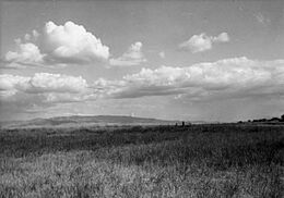
Marker at the first Fort Hall site, 1958
Lua error in Module:Location_map at line 420: attempt to index field 'wikibase' (a nil value).
Location 11 mi. W of Fort Hall,
Fort Hall Indian Reservation
Built 1834; 191 years ago (1834)
NRHP reference No. 66000306
Significant dates
Added to NRHP October 15, 1964
Designated NHL January 20, 1961
Fort Hall Site
Fort Hall (United States Army, 1873-1883)
Lua error in Module:Location_map at line 420: attempt to index field 'wikibase' (a nil value).
Nearest city Blackfoot, Idaho
Area 160 acres (65 ha)
Built 1870; 155 years ago (1870)
NRHP reference No. 74000732
Added to NRHP November 21, 1974

Fort Hall was an important fort in the western United States. It was built in 1834 by Nathaniel Jarvis Wyeth as a place for trading furs. The fort was located along the Snake River in what is now southeastern Idaho.

Wyeth was a businessman from Boston, Massachusetts. He also built another trading post, Fort William, in what is now Portland, Oregon. His goal was to create a new company for trading and fishing. However, in 1837, Wyeth could not compete with the powerful British Hudson's Bay Company. So, he sold both of his forts to them.

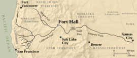
For many years, both Great Britain and the United States claimed the Oregon Country. After the United States gained control of the area in 1846, Fort Hall became a very important stop. It was a key station for people traveling west on the Oregon Trail during the 1850s. About 270,000 people passed through Fort Hall on their journey.

The town of Fort Hall later grew about eleven miles (18 km) to the east. The city of Pocatello developed about thirty miles (50 km) south.

In the 1860s, Fort Hall was a main stop for mail, supplies, and stagecoaches. These services connected to mining towns in the Pacific Northwest. In 1870, a new Fort Hall was built about 25 miles (40 km) northeast to help protect these routes.

Fort Hall is seen as the most important trading post in the Snake River Valley. Today, it is part of the Fort Hall Indian Reservation. No original buildings remain at either site. The old Fort Hall site was named a National Historic Landmark in 1961. The new Fort Hall site is listed on the National Register of Historic Places.

History of Fort Hall

This area was home to different groups of indigenous peoples for a very long time. By the time Europeans arrived, the Shoshone and Bannock peoples had lived here for centuries. They called the area Botoode in their Shoshoni language.

These groups were like other Plains peoples. They used horses to hunt bison and move around with the seasons. French and British traders had been trading with them long before American explorers came to the area.

The Oregon Country

In the late 1820s, some men from Boston, like Hall J. Kelley, became interested in making money in the Oregon Country. They saw it as a place for new business adventures. Kelley asked Nathaniel Jarvis Wyeth, a clever businessman, to join his plan. Wyeth had already made the ice business very successful in Boston.

They planned to go on a trip together in 1831. Their goal was to start a company for trading furs and catching salmon. They hoped to compete with the famous cod fishing industry in New England. However, their trip was delayed and never happened.

In 1832, Wyeth decided to go on his own. He led a group of 70 to 100 men. He wanted to build a fishing and trading post on the Columbia River. This spot was near where the Willamette River joins it, close to present-day Portland, Oregon.

Wyeth also planned to sell goods to trappers in the Rocky Mountains. He even thought about drying bison meat to sell in Cuba. A main investor in his company was Henry Hall. Besides furs, they wanted to send salmon to New England and Hawaii.

In 1832, Benjamin Louis Eulalie de Bonneville was the first to take wagons over the South Pass in the Rocky Mountains. Trappers had found this route again in 1824. This path led to the North Platte River valley. It was becoming a key route for wagons connecting the East to the Oregon Country.

The Platte Rivers were important travel paths. Their valleys offered flat land for wagons. This route stretched for 500 miles (800 km) from the fur trading towns of Independence and St. Joseph, Missouri. Other travelers started their journey from St. Louis, Missouri. This city was a center for fur companies and suppliers for people moving west.

Native Americans had used South Pass for a long time. They had also guided the Lewis and Clark Expedition on a more northern trail in 1804–1806. This northern trail went into Oregon and to the Pacific Coast. But it had many difficult spots, turns, and steep paths. This made it hard for wagon trains, mules, and oxen, which were the main animals used by travelers.

In 1834, trappers held their yearly rendezvous at a meadow near Hams Fork. This was close to what is now Granger, Wyoming. These events were times for independent trappers and traders, called mountain men, to sell furs to fur company agents. The agents would then give the traders new supplies. The rendezvous events lasted several days. They were for business, but also very festive, often with alcohol.

Old Fort Hall (1834–1856)

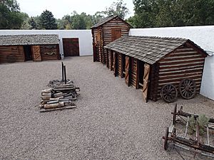
Fort Hall Replica, Courtyard, Pocatello ID
Courtyard of a 1960s replica of Fort Hall in Pocatello.

In July 1834, Wyeth faced a problem. Even though he had a contract with Milton Sublette of the Rocky Mountain Fur Company, their agents at the rendezvous refused his goods. They only paid him enough to cover his advance and a penalty. They said they were closing their business.

Wyeth told his investors, Tucker & Williams, about the trouble. Since he was left with many goods, he decided to travel west. He planned to go about 150 miles (240 km) to the Snake River area in present-day southeastern Idaho. He hoped to do business there. He sent messages ahead to Native American tribes, asking them to bring bison robes for trading.

Wyeth and his group traveled west about 150 miles (240 km) to the Snake River. They stopped near the mouth of the Portneuf. There, they built the wooden buildings for Fort Hall. Wyeth named the fort after Henry Hall, a main investor in his trip. They finished building a palisade (a fence of strong wooden stakes) around the fort on July 31, 1834. It was the only outpost built by European Americans in that part of the Oregon Country.

The Oregon boundary dispute was a disagreement between the United States and Great Britain. Because of this, the region was open for people to settle and do business. But no country could officially claim it yet. In reality, the Hudson's Bay Company (HBC) from Britain had almost complete control over trade in the area. This British company controlled the lands around the Columbia River.

The HBC made it very hard for independent trappers and traders to make money. They also greatly reduced the profits of larger American fur trading companies. Most of these American companies were based in St. Louis. Between the Hudson's Bay Company and John Jacob Astor's American Fur Company, new companies often failed quickly. Most mountain men eventually started working under contract for the big companies.

After Fort Hall was finished, Wyeth continued toward the Columbia River with his group. On the way, they met the Methodist missionary Jason Lee. Lee was traveling to start the Methodist Mission in the Willamette Valley. Once Wyeth reached the lower Columbia River, he built Fort William. He hoped this would be a regular meeting place on the Columbia.

The HBC had been trapping in the Snake River area for years. They used their trading post at Fort Boise to compete with Wyeth's company. Eventually, they forced his company out of business. Wyeth then sold Fort Hall to the HBC. The demand for furs was already going down. Furs were becoming harder to find because too many animals had been trapped. Also, people in Europe wanted furs less due to changes in fashion.

In August 1837, Wyeth sold both of his forts to the Hudson's Bay Company (HBC). The HBC controlled most of the fur trade in the Oregon Country. Their main office was at Fort Vancouver on the Columbia River. The British did not want American pioneers to settle in Oregon. So, the HBC managers at Fort Hall tried to discourage new travelers. They would show new settlers the abandoned wagons of earlier travelers. These travelers had lost their oxen and were forced to continue on foot.

Oregon Migration

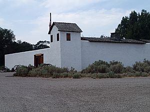
Fort Hall Replica, Southeast Corner, Pocatello ID
Replica of the first Fort Hall in Pocatello.

In 1843, Marcus Whitman, a missionary, led a group of wagons westward from Fort Hall. He had built a mission near what is now Walla Walla, Washington. The British had tried to discourage him, but he went anyway.

Whitman's reports reached the eastern United States. At that time, many Americans strongly believed in "manifest destiny." This was the idea that the United States was meant to expand across the continent. Whitman's reports started a growing wave of settlers moving west each year.

More settlers were encouraged by politics. Democrats in the U.S. government wanted to settle the "Oregon Question." They suggested a border much farther north than today's boundary between the United States and Canada. Political slogans like "Fifty-four forty or fight" were popular during election years.

Also, Democrats controlled the U.S. legislatures. The demand for furs had dropped sharply. And Mexico declared war on the U.S. after Texas became part of the U.S. All these things sped up talks about the border. Finally, a treaty was quickly approved by the Senate. This treaty set the current border. No one wanted to cause problems for their political parties or the President. Fighting two wars in different places at the same time did not make sense.

The treaty led to a huge increase in settlers heading west in 1846. The Mormon Exodus had already begun from Illinois and Missouri. The U.S. Army sent soldiers to patrol and protect the road.

In the years that followed, the number of wagon trains going west grew greatly. Fort Hall became a welcome stop for hundreds of thousands of travelers. It remained an important trading post for mountain men and the Native Americans of the region, especially the Shoshone.

In 1846, the Oregon Treaty set the boundaries in the Northwest between Great Britain (Canada) and the United States. Fort Hall became part of the U.S. and its territories. From 1849 to 1850, a U.S. military camp called Cantonment Loring was located about three miles (5 km) downriver from Fort Hall. Soldiers were stationed there to protect the Oregon Trail. But the camp was closed because it was too hard to get supplies over such long distances. Instead, after 1855, the Army sent groups from Oregon each summer to guard the trail to Fort Hall as more people moved west.

Civil War and After

When the Civil War started in 1861, fewer people traveled west. The Army left Fort Hall. It was briefly used by volunteer soldiers from the Union Army. In 1863, floods from the Snake River washed away the Old Fort Hall.

Fort Hall was rebuilt in 1864. It was moved to Spring Creek, just north of the original site. Parts of the old fort were used to build the new, stronger stage station. The next year, the site was abandoned again. The volunteer troops moved to Camp Lander until 1866. This camp was about three miles (5 km) southeast of the original Fort Hall. It was at the meeting point of the Salt Lake and Boise roads.

In 1867, the United States created the Fort Hall Indian Reservation. This was for the Shoshone and Bannock people. They had faced many years of settlers moving onto their lands. The town of Fort Hall grew about 11 miles (18 km) east of the old trading post and fort. Both are now within the reservation. In 1961, the site of the first Fort Hall, which has a memorial, was named a National Historic Landmark.

A copy of the original Fort Hall was built in the 1960s in Pocatello. This is about thirty miles (50 km) away. It is now a public museum.

New Fort Hall

On May 27, 1870, the U.S. Army built another military Fort Hall. This one was on Lincoln Creek, about twelve miles (20 km) east of the Snake River. It was also about 25 miles (40 km) northeast of the old Fort Hall. Captain James Edward Putnam and a group of soldiers built this new fort.

Army soldiers were stationed there to protect stagecoach travelers, the U.S. mail, and workers going to mining areas in the Northwest. The Army left this fort on June 11, 1883.

The government then gave the land and buildings to the Bureau of Indian Affairs (BIA). The BIA changed the buildings into an Indian boarding school. This was part of a movement in the late 1800s to create schools where Native American children would live. The goal was to teach them English and European-American culture. The buildings were later moved to Ross Fork Creek within the reservation.

None of the original buildings remain at either the old or new fort sites. The 1870 site of the new fort is also listed on the National Register of Historic Places.

See also

kids search engine
Fort Hall Facts for Kids. Kiddle Encyclopedia.