
Brewster, Washington facts for kids
Quick facts for kids
Brewster
|
|
|---|---|
| City of Brewster | |

The outskirts of Brewster
|
|

Location of Brewster, Washington
|
|
| Country | United States |
| State | Washington |
| County | Okanogan |
| Area | |
| • Total | 1.51 sq mi (3.90 km2) |
| • Land | 1.15 sq mi (2.98 km2) |
| • Water | 0.35 sq mi (0.92 km2) |
| Elevation | 814 ft (248 m) |
| Population
(2020)
|
|
| • Total | 1,983 |
| • Density | 1,313/sq mi (508.5/km2) |
| Time zone | UTC-8 (Pacific (PST)) |
| • Summer (DST) | UTC-7 (PDT) |
| ZIP code |
98812
|
| Area code(s) | 509 |
| FIPS code | 53-07835 |
| GNIS feature ID | 1516938 |
| Website | City of Brewster |
Brewster is a small city in Okanogan County, Washington, in the United States. In 2020, about 1,983 people lived there.
Contents
History of Brewster
Brewster was started in 1896. A post office opened there two years later, in 1898. The city is named after John Bruster, who was one of the first people to settle in the area.
Where is Brewster Located?
Brewster is located where two important rivers meet: the Okanogan River and the Columbia River. The city covers about 1.19 square miles (3.08 square kilometers) of land.
Important Places in Brewster
- Three Rivers Hospital: This hospital has 30 beds and serves the city. It is the largest hospital in Okanogan County.
- Radio Telescope: Brewster is home to a special radio telescope. It is the northernmost of ten dishes that make up the Very Long Baseline Array. This array is a group of telescopes that work together to study space.
People in Brewster
| Historical population | |||
|---|---|---|---|
| Census | Pop. | %± | |
| 1910 | 296 | — | |
| 1920 | 394 | 33.1% | |
| 1930 | 413 | 4.8% | |
| 1940 | 447 | 8.2% | |
| 1950 | 851 | 90.4% | |
| 1960 | 940 | 10.5% | |
| 1970 | 1,059 | 12.7% | |
| 1980 | 1,337 | 26.3% | |
| 1990 | 1,633 | 22.1% | |
| 2000 | 2,189 | 34.0% | |
| 2010 | 2,370 | 8.3% | |
| 2020 | 1,983 | −16.3% | |
| U.S. Decennial Census 2020 Census |
|||
What the 2010 Census Showed
In 2010, there were 2,370 people living in Brewster. There were 699 households, which are groups of people living together.
About 54.5% of these households had children under 18 years old. Many families were married couples living together. The average household had about 3.31 people.
The average age of people in Brewster was 27.6 years old.
- About 35.1% of residents were under 18.
- About 10% were 65 years or older.
Most people in Brewster were White (50.8%). A large part of the population, 73.0%, identified as Hispanic or Latino.
Climate in Brewster
| Climate data for Brewster, Washington | |||||||||||||
|---|---|---|---|---|---|---|---|---|---|---|---|---|---|
| Month | Jan | Feb | Mar | Apr | May | Jun | Jul | Aug | Sep | Oct | Nov | Dec | Year |
| Record high °F (°C) | 57 (14) |
64 (18) |
78 (26) |
93 (34) |
103 (39) |
108 (42) |
110 (43) |
110 (43) |
103 (39) |
86 (30) |
75 (24) |
59 (15) |
110 (43) |
| Mean daily maximum °F (°C) | 35 (2) |
42 (6) |
55 (13) |
65 (18) |
74 (23) |
81 (27) |
90 (32) |
90 (32) |
80 (27) |
63 (17) |
45 (7) |
34 (1) |
63 (17) |
| Mean daily minimum °F (°C) | 23 (−5) |
26 (−3) |
32 (0) |
38 (3) |
45 (7) |
52 (11) |
58 (14) |
57 (14) |
48 (9) |
37 (3) |
30 (−1) |
22 (−6) |
39 (4) |
| Record low °F (°C) | −19 (−28) |
−19 (−28) |
2 (−17) |
19 (−7) |
26 (−3) |
33 (1) |
35 (2) |
35 (2) |
29 (−2) |
10 (−12) |
−9 (−23) |
−19 (−28) |
−19 (−28) |
| Average precipitation inches (mm) | 1.38 (35) |
1.09 (28) |
0.90 (23) |
0.55 (14) |
0.96 (24) |
0.90 (23) |
0.56 (14) |
0.26 (6.6) |
0.39 (9.9) |
0.60 (15) |
1.43 (36) |
1.86 (47) |
10.88 (275.5) |
Images for kids
-
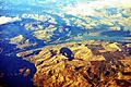
An aerial view of Brewster, next to the Columbia River.

See also
 In Spanish: Brewster (Washington) para niños
