
Okanagan Country facts for kids

The Okanagan Country, also known as the Okanagan Valley, is a special region. It stretches across both the Canadian province of British Columbia and the U.S. state of Washington. In Washington, it's spelled the Okanogan Country. This area is defined by the Okanagan Lake and the Okanagan River.
About 400,000 people live in the Okanagan Country. It goes from a place called Grindrod, British Columbia in Canada all the way to Douglas County, Washington in the USA. The biggest city in the Canadian part is Kelowna. In the American part, the largest city is Omak. The region got its name from the Okanagan language term, ukʷnaqín.
The Okanagan Country has a mild climate. It's also close to many lakes, rivers, and mountains. This makes it a great place for outdoor activities and vacations. The main jobs here used to be farming and forestry. But now, more people are moving here to retire, and tourism is also very popular. The American part of the region is more quiet and has fewer people.
Contents
Exploring the Okanagan's Geography

The northern part of the Okanagan Country is mountainous and hilly. This area is defined by the Shuswap Highland and Thompson Plateau, starting near Grindrod, British Columbia. The southern border reaches into Chelan, Douglas, and Grant counties in the USA.
The border between Canada and the USA runs through the region. You can cross it at Osoyoos in Canada and Oroville in the USA. The main land features are the Okanagan Highland and the Okanagan Basin. These are like hilly, flat areas called plateaus.
The most important water features are the Okanagan River and Okanagan Lake. Together, they cover a huge area. The entire region is very large, bigger than countries like Belgium or Taiwan! The biggest town by land size is Spallumcheen in Canada. It's even larger than the city of Seattle. The southernmost community is Electric City in Washington.
Many other beautiful lakes and rivers are found here. These include Alta Lake, Columbia River, Kalamalka Lake, Mahoney Lake, Mara Lake, Omak Lake, Osoyoos Lake, Similkameen River, Shuswap River, Skaha Lake, Swan Lake, Tuc-el-nuit Lake, Vaseaux Lake, and Wood Lake.
Understanding the Okanagan's Climate
The Okanagan Country has a semi-arid climate. This means it doesn't get much rain. Summers are hot, and winters are not too cold. This climate is common in southern British Columbia and central Washington.
The northern parts of the region get more rain and have cooler temperatures. Kelowna is like a dividing line. South of Kelowna, it's semi-arid. North of Kelowna, the climate changes to a more humid continental type.
The plants in the region change with the climate. In the drier southern areas, you might see cactus and sagebrush. In the wetter northern areas, you'll find cedar and hemlock trees. The region was also affected by a large earthquake in 1872. Its center was near Omak Lake.
Major Towns and Cities in the Okanagan
The Okanagan Country is home to many towns and cities. These communities are spread across different areas in both Canada and the USA.


Some of the larger cities include Kelowna, Vernon, and Penticton in British Columbia. In Washington, important towns are Omak, Okanogan, and Oroville. These communities offer different types of living, from busy city life to quiet rural settings.
How the Okanagan is Governed
In 2009 and 2011, it was estimated that over 400,000 people lived in the Okanagan Country. About 10 percent of these people live in the American part of the region.
For national government, the Canadian part of the Okanagan Country is part of the British Columbia Southern Interior electoral district. The American part is part of Washington's 4th congressional district.
Locally, the Canadian side is divided into regional districts. These include the North Okanagan, Central Okanagan, and Okanagan-Similkameen. In the USA, the region includes Okanogan and Ferry counties. Some parts of Grant, Clark, and Douglas counties are also within the Okanagan Country.
Images for kids
-
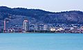
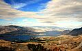
The city of Kelowna, British Columbia.
-
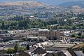
Downtown Vernon, British Columbia.
-
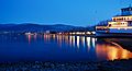
Okanagan Beach in Penticton, British Columbia.
-
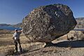
Omak, Washington and its unique balancing rock.
-
The town of Osoyoos, British Columbia.
-
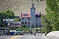
The courthouse in Okanogan, Washington.
-
Pateros, Washington by Lake Pateros.
