
Osoyoos Lake facts for kids
Quick facts for kids Osoyoos Lake |
|
|---|---|
 |
|

Osoyoos Lake
Location in Washington (state)

Osoyoos Lake
Location in British Columbia

Osoyoos Lake
Location in the United States

Osoyoos Lake
Location in Canada
|
|
| Location | Regional District of Okanagan-Similkameen, British Columbia, Canada / Okanogan County, Washington, United States |
| Coordinates | 49°0′1.16″N 119°26′44.13″W / 49.0003222°N 119.4455917°W |
| Basin countries | Canada, United States |
| Settlements | Osoyoos, British Columbia; Oroville, Washington |
Osoyoos Lake is a beautiful lake that stretches across the border between Canada and the United States. Part of the lake is in British Columbia, Canada, and the other part is in Washington, USA.
The name Osoyoos comes from the word sẁiẁs. This word is from the local Okanagan language (Syilx'tsn). It means "narrowing of the waters," which describes how the lake looks.
Two towns are located right on the shores of Osoyoos Lake. On the Canadian side, you'll find the town of Osoyoos, British Columbia. On the American side, there's the city of Oroville, Washington.
Understanding Osoyoos Lake's Water Flow
Osoyoos Lake and the Okanogan River (which flows into and out of it) are very important. The river is called the Okanagan River in Canada. The way water flows in and out of the lake is managed by special agreements. These agreements are between Canada and the United States.
International Water Agreements
These water-sharing agreements are overseen by the International Joint Commission. This group helps manage shared waters in the Columbia Basin. The International Osoyoos Lake Board of Control makes sure these agreements are followed.
This board includes experts from both countries. They come from groups like Environment Canada, the BC Ministry of Water, Land Air Protection, the US Army Corps of Engineers, and the US Geological Survey. Their job is to make sure the lake's water levels are fair for everyone.

Images for kids
-
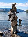
Inuksuk on Osoyoos Lake shore of Sẁiẁs Provincial Park in Osoyoos, looking south with Washington state near Oroville in the distance (July 2020)

