
Tonasket, Washington facts for kids
Quick facts for kids
Tonasket
|
|
|---|---|
| Tonasket, Washington | |

Tonasket in 2008
|
|

Location of Tonasket, Washington
|
|
| Country | United States |
| State | Washington |
| County | Okanogan |
| Area | |
| • Total | 0.96 sq mi (2.49 km2) |
| • Land | 0.94 sq mi (2.44 km2) |
| • Water | 0.02 sq mi (0.05 km2) |
| Elevation | 919 ft (280 m) |
| Population
(2020)
|
|
| • Total | 1,103 |
| • Density | 1,149/sq mi (443.0/km2) |
| Time zone | UTC-8 (Pacific (PST)) |
| • Summer (DST) | UTC-7 (PDT) |
| ZIP code |
98855
|
| Area code(s) | 509 |
| FIPS code | 53-71890 |
| GNIS feature ID | 1527301 |
| Website | City of Tonasket |
Tonasket is a city in Okanogan County, Washington, United States. In 2020, about 1,103 people lived there.
Contents
History of Tonasket
How Tonasket Began
Tonasket became an official city on December 16, 1927. It is named after a very important local leader, Chief Tonasket. He was a chief of the Okanagan people. After the Canada–United States border was drawn in 1846, Chief Tonasket became the main leader for the American Okanogan people. This was a big change, as the previous main chief lived north of the new border.
Where is Tonasket Located?
Tonasket is located in north-central Okanogan County, Washington. It sits on the eastern bank of the Okanogan River. The main highway, U.S. Highway 97, goes right through the city. This highway continues north to the border with Canada, which is about twenty miles away. Another important road, Washington State Route 20, also passes through Tonasket. The city has natural borders: Siwash Creek to the north, Bonaparte Creek to the south, and the Okanogan River to the west.
Tonasket's Industries and Famous People
Tonasket has had a U.S. post office since 1901. The city was planned out in 1910. It is a central place for farming and forestry in the northern part of Okanogan County. You can find three large fruit storage and processing places here. The offices for the Tonasket Ranger District of the Colville National Forest are also in the city.
Many families who first settled in Tonasket still live there today. They are very interested in keeping their history alive. One famous person who grew up near Tonasket was Walter H. Brattain. He lived on a cattle ranch and went to school in Tonasket. In 1956, he won the Nobel Prize for Physics. He shared this award for helping to invent the transistor, which is a tiny electronic switch used in almost all modern electronics!
The Okanogan Family Barter Faire
In 1973, a special event called the Okanogan Family Barter Faire started in Tonasket. It was created by Michael Pilarski of the Friends of the Trees Society. The idea was to help people trade and sell their extra produce and handmade items before winter.
Today, this fair is a huge annual event. Thousands of people come from all over the region. They can buy, sell, and trade all sorts of things. This includes art, crafts, old clothes, and fresh produce. Visitors can also learn about things like sustainable farming and natural remedies. Plus, there's always live music and fun entertainment! It's a big celebration of living simply and connecting with others.
Geography of Tonasket
Tonasket is located along the Okanogan River. It is about 919 feet (280 meters) above sea level. The city covers a total area of about 0.96 square miles (2.49 square kilometers). Almost all of this area is land.
Tonasket also has its own airport, called Tonasket Municipal Airport (W01). It opened in 1990. The airport has one paved runway that is 3,053 feet (930 meters) long. It is located about 2 miles (3 kilometers) northwest of the town.
Climate in Tonasket
Tonasket has a type of climate called a dry-summer continental climate. This means it has warm, dry summers and cold winters.
Population and People
| Historical population | |||
|---|---|---|---|
| Census | Pop. | %± | |
| 1930 | 513 | — | |
| 1940 | 643 | 25.3% | |
| 1950 | 957 | 48.8% | |
| 1960 | 958 | 0.1% | |
| 1970 | 951 | −0.7% | |
| 1980 | 985 | 3.6% | |
| 1990 | 847 | −14.0% | |
| 2000 | 994 | 17.4% | |
| 2010 | 1,032 | 3.8% | |
| 2020 | 1,103 | 6.9% | |
| U.S. Decennial Census 2020 Census |
|||
How Many People Live Here?
As of the 2010 census, there were 1,032 people living in Tonasket. These people lived in 453 households. The city had about 1,290 people per square mile.
Most of the people living in Tonasket were White. There were also people from other backgrounds, including Native American, Asian, and African American residents. About 16.5% of the population identified as Hispanic or Latino.
The average age of people in Tonasket was about 47.5 years old. About 19.3% of the residents were under 18 years old. Many people were also 65 years or older, making up 26.3% of the population. The city had slightly more females than males.
Images for kids
-
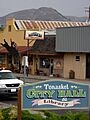
Tonasket in 2008
-
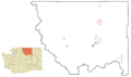
Location of Tonasket, Washington
See also
 In Spanish: Tonasket (Washington) para niños
