Glacial Lake Columbia facts for kids
Quick facts for kids Lake Columbia |
|
|---|---|

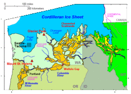
Cordilleran Ice Sheet maximum extent of Glacial Lake Missoula (eastern) and Glacial Lake Columbia (western) areas swept by Missoula and Columbia floods
|
|
| Location | North America |
| Coordinates | 47°57′N 118°58′W / 47.95°N 118.96°W |
| Lake type | former lake |
| Primary inflows | Corderillian Ice Sheet |
| Primary outflows | Foster Coulee Moses Coulee Grand Coulee |
| Basin countries | United States |
| Max. length | 30 mi (48 km) |
| Max. width | 20 mi (32 km) |
| Surface area | 500 sq mi (1,295 km2) |
| Max. depth | 600 ft (183 m) |
| Water volume | { |
| Surface elevation | 1,600 ft (488 m) |
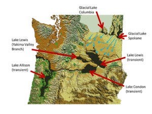
Glacial Lake Columbia was a huge ancient lake in central Washington state. It formed a long, long time ago during the Ice Age, when a giant sheet of ice, called the Cordilleran Ice Sheet, blocked the Columbia River. This ice dam made the river water back up, creating a massive lake.
This ancient lake was much bigger than the lake behind the Grand Coulee Dam today. When the ice dam grew, the lake's water had to find new ways to flow out. It carved out huge canyons like Foster Coulee, Moses Coulee, and finally, the famous Grand Coulee.
Contents
Glacial Lake Columbia: An Ice Age Giant
Glacial Lake Columbia was created by a part of the Cordilleran Ice Sheet called the Okanogan lobe. This giant ice lobe covered about 500 square miles (1,300 km2) of the Waterville Plateau in central Washington. It acted like a huge wall, blocking the normal path of the Columbia River.
The water from the blocked Columbia River then started to fill up the area behind the ice dam. This created Glacial Lake Columbia. As the ice dam grew bigger, the lake also grew, and its water had to find new paths to drain. These new paths became deep canyons, known as coulees.
The Mighty Missoula Floods
At the same time, another part of the Cordilleran Ice Sheet blocked the Clark Fork River in Montana. This created another huge lake called Glacial Lake Missoula. This lake was held back by an ice dam that was about 2,000 feet (610 m) tall!
Over thousands of years, this ice dam would break many times. Each time it broke, it released a massive amount of water. These events are known as the Missoula Floods. There were about 40 of these huge floods!
How the Floods Affected Lake Columbia
When the Missoula Floods happened, their water rushed down the Columbia River drainage. This water passed right through Glacial Lake Columbia. Since Lake Columbia was already blocked by the Okanogan ice lobe, which was very tall (about 1,300 metres (4,300 ft) high), it changed the path of these floods.
The ice lobe forced the floodwaters to spread out across much of eastern Washington state. The incredible power of these floods carved out many famous landforms we see today. These include the Grand Coulee, Dry Falls, Palouse Falls, and the unique Channeled Scablands.
Clues in the Lake Bed
Scientists have studied the bottom of where Glacial Lake Columbia used to be. They found special layers of dirt and rock called "flood deposits." These layers show that the floods happened over and over again.
Between the flood deposits, scientists also found annual deposits, called varves. These are like tree rings, showing yearly layers of sediment. Since Glacial Lake Columbia stayed full between the big Missoula Floods, these yearly layers could form.
By counting the annual layers between the flood deposits, scientists could figure out how often the ice dam in Montana broke. They found that the Missoula Floods happened roughly every 35 to 55 years. This helps us understand the amazing history of these ancient lakes and floods!
 | Ernest Everett Just |
 | Mary Jackson |
 | Emmett Chappelle |
 | Marie Maynard Daly |


