Moses Coulee facts for kids
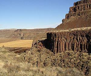
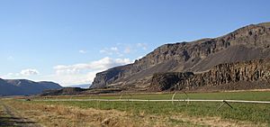
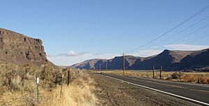
Moses Coulee is a huge canyon in Douglas County, Washington. It's like a giant, dry riverbed that was carved out by massive floods long ago. Moses Coulee is the second biggest canyon in an area called the Channeled Scablands. It's about 30 kilometers (18.6 miles) west of the even bigger Grand Coulee.
Even though it's dry now, this canyon was once filled with incredible amounts of water. During the Ice Ages, huge floods, much bigger than any river today, rushed through here. These floods carved out the deep canyon we see. Scientists believe these "megafloods" came from a giant ancient lake called Lake Missoula. Some also think floods from under a huge ice sheet helped shape the coulee. The end of Moses Coulee opens up into the Columbia River.
Moses Coulee is so special that two parts of it were named National Natural Landmarks in 1986. These are places that show the best examples of certain natural features.
- The Great Gravel Bar of Moses Coulee is a huge pile of rocks and gravel. It was formed by the powerful Missoula Floods that swept across the land before the last Ice Age. It's considered the best example of its kind.
- Withrow Moraine and Jameson Lake Drumlin Field shows amazing examples of drumlins (small, oval hills made by glaciers) and a "terminal moraine" (a ridge of rocks and dirt left by the very edge of a glacier). These features are unique because they clearly show how glaciers and huge floods worked together to shape the land.
The canyon is named after Chief Moses (1829–99), a leader of the Sinkiuse-Columbia people.
Contents
How Moses Coulee Was Formed
Moses Coulee is part of the Columbia River Plateau, a large area in Washington, Oregon, and Idaho. This plateau is made up of many layers of volcanic rock called basalt.
Ancient Volcanoes and Lava Flows
Millions of years ago, during the late Miocene and early Pliocene times, huge amounts of lava erupted from cracks in the ground. This was one of the biggest lava flows ever seen on Earth! It covered about 163,700 square kilometers (63,000 square miles) of the Pacific Northwest. Most of this lava erupted between 17 and 14 million years ago. These layers of hardened lava were later exposed by the powerful floods that carved Moses Coulee.
The Ice Age and Glaciers
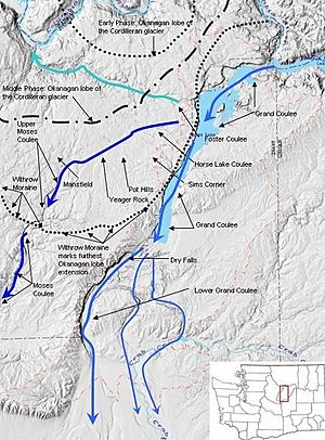
During the Pleistocene Ice Age, huge glaciers moved across the land. A part of the Cordilleran Ice Sheet called the Okanogan Lobe pushed south, reaching as far as the town of Withrow. We know glaciers were here because of clues they left behind:
- Smooth, scratched rocks where the ice slid over them.
- Giant rocks called glacial erratics that were carried far from their original homes.
- Small hills called drumlins.
- Ridges of sand and gravel called eskers and moraines.
- Channels carved by melting ice.
- A mix of clay, sand, and rocks called glacial till.
The Withrow Moraine is a clear sign of how far south the Okanogan Lobe reached. As the glacier grew, it blocked the Columbia River, creating huge lakes like Glacial Lake Columbia.
How the Canyon Was Carved
Before the giant floods, Moses Coulee was already a valley with smaller streams flowing into the Columbia River. You can still see these old streambeds along the canyon walls today, looking like "cut off" valleys.
As the Okanogan glacier moved, it blocked the Okanogan River valley and covered a large part of the Waterville Plateau. It also blocked the ancient path of the Columbia River. The water backed up, forming Glacial Lake Columbia. At first, the Columbia River found a new path through the head of Grand Coulee and then through Foster Coulee.
But as the glacier grew even bigger, it blocked Foster Coulee too. So, the Columbia River found its next lowest path, which was through Moses Coulee! This meant the mighty Columbia River flowed through Moses Coulee for a while.
Then, the Okanogan glacier grew even more and blocked Moses Coulee as well. The Columbia River had to find yet another path, and that's how the modern Grand Coulee was formed. The Columbia River then flowed through Grand Coulee and the Dry Falls area before rejoining its usual path.
Even though the Columbia River only flowed through Moses Coulee for a short time, this period included some of the most powerful Missoula Floods. These floods were so strong they carved the deep canyon we see today.
After the Ice Melted
When the Okanogan glacier melted, it left behind a lot of material in the upper parts of Moses Coulee, especially in the Withrow Moraine. This included a thick layer of glacial till, made of clay, silt, sand, gravel, and huge boulders.
Today, Moses Coulee is a great example of a shrub-steppe ecosystem. This means it's a dry area with lots of shrubs and grasses. You can find plants like sagebrush, rabbitbrush, greasewood, and different types of bunchgrass.
Moses Coulee Preserve
The Nature Conservancy has created the Moses Coulee Preserve. This is a protected area of about 3,588 acres (14.5 square kilometers) that keeps the natural shrub-steppe habitat safe. It's located about 2 miles (3.2 km) south of Jameson Lake, near the start of Moses Coulee.
This preserve is home to many different kinds of plants and animals:
- Birds: You might see colorful lazuli buntings, common goldeneye ducks, sage thrashers, sage sparrows, and even golden eagles soaring above.
- Plants: Beautiful wildflowers like sagebrush buttercups, shooting stars, and sego lilys grow here. There are also shrubs like serviceberry and mock orange.
- Animals: The preserve provides a home for mule deer, least chipmunks, different types of bats, and marmots.
 | Charles R. Drew |
 | Benjamin Banneker |
 | Jane C. Wright |
 | Roger Arliner Young |


