
Mica Peak facts for kids
Quick facts for kids Mica Peak, Idaho & Mica Peak, Washington |
|
|---|---|

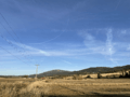
Mica Peak, Idaho (left) and Mica Peak, Washighton (right) as viewed from Eagle Peak in Spokane County.
|
|
| Highest point | |
| Elevation |
|
| Prominence | 2,661 ft (811 m) |
| Geography | |
| Location | |
| Parent range | Selkirk Mountains |
| Topo map | USGS Rockford Bay |
Mica Peak is a special name because it belongs to two different mountain tops! These two peaks are found in the United States, not too far from each other. One is in Washington state, and the other is in Idaho.
These two mountains are part of the same long ridge. This ridge helps separate the Spokane Valley and Rathdrum Prairie areas from a region called the Palouse. The two Mica Peaks are very close in height, with only about 31 ft (9.4 m) difference between them. They are also the southernmost peaks of the Selkirk Mountains.
Contents
What is Mica Peak?
Mica Peak is the name given to two mountain summits that are quite close to each other. One peak is located in Spokane County, Washington. The other is in Kootenai County, Idaho. Even though they share a name, they are distinct mountains.
Mica Peak in Idaho
The Mica Peak in Kootenai County, Idaho, is also sometimes called Signal Point. This peak is a bit taller than its Washington neighbor. It stands at an elevation of about 5,243 feet (1,598 m). The closest town to this peak is State Line, which is about seven miles (11 km) away.
The Old Ski Lodge
The name Signal Point comes from an old ski lodge. This lodge used to operate on the northeast side of the mountain. It was open during the 1950s and 1960s. The ski lodge had a simple rope tow to help skiers get up the slope. The building for the lodge is no longer there today.
Mica Peak in Washington
The Mica Peak located in Spokane County, Washington, is slightly shorter. Its elevation is about 5,209 feet (1,588 m). This mountain is the very last peak at the southern end of the Selkirk Mountains.
The Air Force Station
This peak was once home to the Mica Peak Air Force Station. This station was used by the Air Force but is now closed down.
What About Cable Peak?
Cable Peak is another mountain summit in Kootenai County, Idaho. It is about 4,924 ft (1,501 m) tall. This peak is also found along the same ridge as the two Mica Peaks. A stream called Cable Creek actually starts on the northern side of Cable Peak.
Images for kids
-
Mica Peak (Washington) viewed from the community of Mica, Washington; the Mica Peak Radar Station is visible at the summit.

