Greenacres, Washington facts for kids
Quick facts for kids
Greenacres, Washington
|
|
|---|---|
|
Locale
|
|

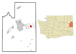
Location of the CDP of Greenacres, Washington at the 2000 Census
|
|
| Country | United States |
| State | Washington |
| County | Spokane |
| Area | |
| • Total | 3.4 sq mi (8.7 km2) |
| • Land | 3.3 sq mi (8.6 km2) |
| • Water | 0.1 sq mi (0.1 km2) |
| Population
(2000)
|
|
| • Total | 5,158 |
| • Density | 1,554.7/sq mi (600.3/km2) |
| Time zone | UTC-8 (Pacific (PST)) |
| • Summer (DST) | UTC-7 (PDT) |
| ZIP code |
99016
|
| Area code | 509 |
| FIPS code | 53-28520 |
| GNIS feature ID | 1505280 |
Greenacres is a place in Spokane County, Washington, United States. It used to be called a "census-designated place" (CDP). This means it was an area the government counted for population, but it wasn't an official city.
Today, most of Greenacres is part of the city of Spokane Valley. A small part is also in Liberty Lake. Greenacres still has its own post office.
The Central Valley School District has two schools named after this area: Greenacres Middle School and Greenacres Elementary School.
History of Greenacres
Greenacres was listed as a "census-designated place" (CDP) in the year 2000. At that time, it was spelled "Green Acres" in the official count.
In March 2003, a new city called Spokane Valley was formed. Most of Greenacres became part of this new city. Because of this, "Greenacres" is now known as an official common name for a place within an already existing city.
Later, in 2006, another part of Greenacres joined the city of Liberty Lake. In the year 2000, the population of Greenacres was 5,158 people.
Geography of Greenacres
Greenacres is located at 47°39′48″N 117°9′24″W / 47.66333°N 117.15667°W. This is its exact spot on a map.
The area of Greenacres used to be about 3.4 square miles (which is about 8.7 square kilometers). Most of this area was land, about 3.3 square miles (8.6 square kilometers). A small part, about 0.1 square miles (0.1 square kilometers), was water.
Population and People
| Historical population | |||
|---|---|---|---|
| Census | Pop. | %± | |
| 1950 | 1,287 | — | |
| 1960 | 2,074 | 61.1% | |
| 1970 | 2,324 | 12.1% | |
| 1990 | 4,626 | — | |
| 2000 | 5,158 | 11.5% | |
| 2007 (est.) | 5,618 | ||
| U.S. Decennial Census 6,913 population in the 2010 Estimate unsourced |
|||
In the year 2000, there were 5,158 people living in Greenacres. There were 2,021 households, which are like homes where people live. Out of these, 1,414 were families.
The population density was about 1,554.7 people for every square mile (or 600.3 people per square kilometer).
About 33.2% of the households had children under 18 living there. Many households, 56.2%, were married couples living together. About 24.6% of all households were made up of people living alone.
The average household had about 2.55 people. For families, the average size was about 3.04 people.
The ages of the people in Greenacres in 2000 were spread out like this:
- 26.8% were under 18 years old.
- 6.5% were between 18 and 24 years old.
- 28.9% were between 25 and 44 years old.
- 24.6% were between 45 and 64 years old.
- 13.1% were 65 years old or older.
The median age, which is the middle age of all the people, was 38 years old. For every 100 females, there were about 97.9 males.
See also
 In Spanish: Green Acres (Washington) para niños
 | Anna J. Cooper |
 | Mary McLeod Bethune |
 | Lillie Mae Bradford |


