
Nine Mile Falls, Washington facts for kids
Quick facts for kids
Nine Mile Falls, Washington
|
|
|---|---|

Nine Mile Dam and part of the community of Nine Mile Falls.
|
|
| Nickname(s):
Nine Mile
|
|
| Country | United States |
| State | Washington |
| County | Spokane County |
| Named for | Nine Mile Dam and for Being Nine Miles from Downtown Spokane |
| Time zone | UTC−8 (PST) |
| • Summer (DST) | UTC−7 (PDT) |
| Zip Code |
99026
|
| Area code(s) | 509 |
Nine Mile Falls is a small community in Washington State, USA. It's not a city, but a place where people live, located in both Spokane County and Stevens County. The community is built along the Spokane River, about 9 miles (14 km) from downtown Spokane. It gets its name because it's near a former waterfall, which has been the site of the Nine Mile Dam since 1908. If you follow the river, the community is about 16 miles (26 km) downstream from downtown Spokane. Nine Mile Falls has its own post office with the ZIP code 99026.
Contents
Geography of Nine Mile Falls
Nine Mile Falls is located about nine miles northwest of downtown Spokane. It sits right along the Spokane River. Other nearby places like Seven Mile and Five Mile Prairie also use numbers in their names. However, Nine Mile Falls is not directly connected to the main city area of Spokane. It's more like an exurb, which means it's a community outside the main city, but still connected to it.
Traveling Through the Community
The community is found along Washington State Route 291, which is also called Nine Mile Road. This road follows the river's path. When you come from Spokane, you first reach the eastern part of Nine Mile Falls. To get to the western part, you turn onto Charles Road. This road crosses the river a short distance past the dam.
Most of the shops and the post office are on the eastern side. The western side has a park, a fire station, a restaurant, and an elementary school. Sontag Park on the west side is where the Spokane River Centennial Trail ends. This trail lets you explore Riverside State Park, which stretches along the river for many miles.
Rivers and Lakes
The Little Spokane River flows into the Spokane River just north of Nine Mile Falls. From this point downstream, the Spokane River forms the border between Spokane and Stevens Counties. The Nine Mile Dam creates the Nine Mile Reservoir. Just downstream from Nine Mile Dam, you'll find Long Lake, also known as Lake Spokane. This is a reservoir created by the Long Lake Dam.
Land and Nature
The land around Nine Mile Falls was shaped by ancient lava flows from the Columbia River Basalt Group. It was also formed by huge floods from melting glaciers, called the Missoula floods. The Spokane and Little Spokane Rivers have also carved out the land over time. The Spokane River changes direction near Nine Mile Falls, flowing around the southern hills of the Selkirk Mountains. The river has cut a deep valley, about 200 feet (61 m) deep, through the flat land. Downstream from the old waterfall, the valley becomes wider and less deep. Areas not used for buildings or farms are covered in ponderosa pine forests.
Local Schools
Nine Mile Falls is part of the Nine Mile Falls School District. The Nine Mile Falls Elementary School is in the community itself. However, the middle and high schools are located in a nearby community called Suncrest.
History of Nine Mile Falls

The Spokane people, a Native American tribe, lived in this area for thousands of years. The rivers provided plenty of salmon, which was a very important food source. Sadly, the salmon runs ended when the Long Lake Dam was built in 1915 without a way for fish to pass. You can still find ancient rock paintings along the Little Spokane River, close to where it meets the Spokane River.
Europeans have been in the Nine Mile area since 1810. That's when the Spokane House was built where the two rivers meet.
Building the Dam and Community
The community of Nine Mile Falls began to grow in 1908. A businessman from Spokane named Jay P. Graves built the Nine Mile Dam. He needed electricity for his streetcar system in Spokane. The power from the dam helped Spokane's streetcar and railway systems grow, which also helped the whole Spokane area expand.
A small village was built near the dam to house the workers and their families. In 1990, the dam's power plant and the old village were added to the National Register of Historic Places. This means they are important historical sites. Today, the historic parts of the dam complex are managed by Avista Utilities, which runs the dam, and Riverside State Park.
Gallery
-
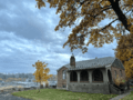
A cottage at the hydroelectric complex with the dam facility visible behind.
-
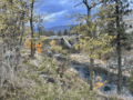
Charles Road crossing the Spokane River and connecting the west and east sides of the community.
-
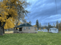
Cottage with yards and sheds in the hydroelectric complex.


See also
 In Spanish: Nine Mile Falls (Washington) para niños
