Mount Spokane facts for kids
Quick facts for kids Mount Spokane |
|
|---|---|

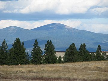
View from northeast Spokane in 2008
|
|
| Highest point | |
| Elevation | 5,887 ft (1,794 m) NAVD 88 |
| Prominence | 3,503 ft (1,068 m) |
| Isolation | 53.5 mi |
| Listing | |
| Geography | |
| Parent range | Selkirk Mountains |
| Topo map | USGS Mount Spokane |
| Climbing | |
| Easiest route | |
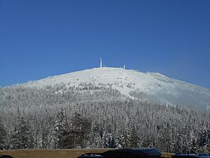
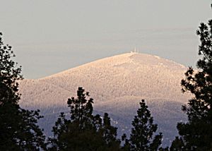
Mount Spokane is a tall mountain in the northwest United States. It is located northeast of Spokane, Washington. The mountain is about 5,887 feet (1,794 meters) high. Until 1912, it was known as Mount Baldy.
Mount Spokane's top is the highest point in Spokane County. It is also one of the tallest peaks in the Inland Northwest. A special feature of the mountain is a bare area on its west and south sides.
The mountain is surrounded by Mount Spokane State Park. This park is the largest in Washington state. It covers about 13,919 acres (56.33 square kilometers).
Just a short distance away, about 1.02 miles (1.64 kilometers) to the east, is Mount Kit Carson. This is the second-highest peak in Spokane County. It is often seen as a smaller peak connected to Mount Spokane.
On the southwest side of Mount Spokane, you'll find the Mount Spokane Ski and Snowboard Park. A non-profit group runs this popular winter sports area.
Contents
Exploring Mount Spokane State Park's History
How Mount Spokane State Park Grew Over Time
Mount Spokane State Park has a rich history. Many people worked to protect and develop this beautiful area. Here are some key moments in its past:
- 1909: Frances Cook, who owned the summit, built a toll road. This road reached within 3 miles (4.8 km) of the top.
- 1927: Mount Spokane State Park was officially opened. It started with about 1,500 acres (6.1 square kilometers).
- 1929: H. Cowles, Jr. gave 640 acres (2.6 square kilometers) of land to the park.
- 1930s: Ski clubs and mountaineering groups bought over 500 acres (2.0 square kilometers). They built lodges, ski lifts, and ski jumps. The road to the summit was also finished.
- 1932: A large "Sun Globe" was put up at the top of the mountain. It was meant to reflect the sun's rays far away. This globe was a tribute to fatherhood and a memorial to the people of Spokane. Mrs. J. B. Dodd, who started Father's Day, helped unveil it. The globe is no longer there today.
- 1934: The Civilian Conservation Corps (CCC) built the Vista House. The CCC was a program that helped people find work during the Great Depression.
- 1935: CCC crews set up camp on Beauty Mountain. They worked to improve roads and build other facilities in the park.
- 1939: The Spokane Chapter of the Conservation League bought 320 acres (1.3 square kilometers) for the park. They paid $1,500 to save old trees from being cut down or burned.
- 1946: The world's first double chairlift started working on the south side of the mountain. This was a big step for skiing!
- 1952: A plan was suggested for the park to grow to over 24,000 acres (97 square kilometers). This plan would have made most of Mount Spokane for downhill skiing. However, it was not put into action.
- 1953: Television station KXLY-TV began broadcasting from the summit.
- 1955: Lodge #1 and Chairlift #1 were built.
- 1961: A company called A.E. Mettler built Lodge #2 and Lift #2.
- 1965: Another plan was made for the park to include 11,592 acres (46.91 square kilometers). This plan was also not approved by the Parks Commission.
- 1974: Mount Spokane Park's official name changed from "recreation area" to "state park." This meant a new way of thinking about the park. It would now focus on helping people connect with nature and enjoy outdoor activities.
- 1978: A plan for trails was created to help different groups use the park without conflict. This plan quickly became outdated and was not fully put into place.
- 1985: The Parks Commission officially named the Ragged Ridge Natural Area within the park.
- 1993: The park had about 13,643 acres (55.21 square kilometers) of land. Much of this land was given as gifts or obtained during the Great Depression. A group also suggested a full planning process for the park's future.
- 1994: State Parks suggested classifying parts of the park as Natural Forest Areas. A task force was formed and recommended a detailed planning process. They also suggested creating a local advisory committee for the park.
- 1995: The Mount Spokane State Park Advisory Committee started meeting monthly. The "Friends of Mount Spokane State Park" group also formed.
- 1997: Mount Spokane 2000, a non-profit group, became the new company to run the ski area. They took over from the previous operator.
- 1999: A new plan called the Classification and Management Plan (CAMP) began for the park. This plan divided the park into different areas for different uses. For example, some areas were for recreation, others for natural resources, and some for preserving nature.
What is the Weather Like on Mount Spokane?
Mount Spokane's Climate Details
Mount Spokane has a climate that changes a lot throughout the year. It gets cold and snowy in winter and warmer in summer. Here's a look at the typical weather:
| Climate data for Mount Spokane, Washington, July 1953 – December 1972 | |||||||||||||
|---|---|---|---|---|---|---|---|---|---|---|---|---|---|
| Month | Jan | Feb | Mar | Apr | May | Jun | Jul | Aug | Sep | Oct | Nov | Dec | Year |
| Record high °F (°C) | 47 (8) |
50 (10) |
54 (12) |
72 (22) |
77 (25) |
83 (28) |
89 (32) |
89 (32) |
81 (27) |
68 (20) |
59 (15) |
46 (8) |
89 (32) |
| Mean daily maximum °F (°C) | 23.1 (−4.9) |
27.6 (−2.4) |
30.3 (−0.9) |
38.2 (3.4) |
49.0 (9.4) |
57.4 (14.1) |
66.5 (19.2) |
66.0 (18.9) |
56.4 (13.6) |
43.1 (6.2) |
32.5 (0.3) |
26.5 (−3.1) |
43.0 (6.1) |
| Mean daily minimum °F (°C) | 13.1 (−10.5) |
18.4 (−7.6) |
19.4 (−7.0) |
24.9 (−3.9) |
35.0 (1.7) |
41.1 (5.1) |
49.3 (9.6) |
48.8 (9.3) |
40.9 (4.9) |
30.8 (−0.7) |
22.5 (−5.3) |
16.9 (−8.4) |
30.1 (−1.1) |
| Record low °F (°C) | −23 (−31) |
−17 (−27) |
−20 (−29) |
10 (−12) |
15 (−9) |
21 (−6) |
25 (−4) |
28 (−2) |
18 (−8) |
4 (−16) |
−17 (−27) |
−28 (−33) |
−28 (−33) |
| Average precipitation inches (mm) | 5.83 (148) |
4.61 (117) |
4.94 (125) |
3.49 (89) |
2.78 (71) |
2.71 (69) |
1.30 (33) |
1.54 (39) |
2.75 (70) |
3.71 (94) |
6.24 (158) |
6.25 (159) |
46.15 (1,172) |
| Average snowfall inches (cm) | 39.1 (99) |
20.5 (52) |
25.9 (66) |
10.9 (28) |
5.0 (13) |
0.6 (1.5) |
0.2 (0.51) |
0 (0) |
1.9 (4.8) |
8.1 (21) |
18.2 (46) |
32.2 (82) |
162.5 (413) |
| Source: Western Regional Climate Center | |||||||||||||
See also
 In Spanish: Monte Spokane (Washington) para niños
 | Emma Amos |
 | Edward Mitchell Bannister |
 | Larry D. Alexander |
 | Ernie Barnes |


